from 15,000 rubles
without own land surveying
In 2021, the cadastre service and the rights registration service merged, and a new structure of the State Property Committee was formed - a unified state real estate cadastre. In fact, since 2021, the term “cadastral error” has been replaced by “registry error”, however, today both terms are still used, they mean the same thing.
What is a cadastral (registry) error?
The discrepancy between the data of the state cadastral register and the actual data is a cadastral error. Errors can be very diverse, for example, information about a land plot may contain incorrect parameters for boundaries, rotations, location, etc.
Errors can be caused by typos or incorrect data provided. However, the basis for entering data about a land plot into the register is the boundary plan; if an error entered the register from the boundary plan, then most likely it was made by a cadastral engineer.
The most common causes of cadastral errors are:
- use of outdated equipment by cadastral engineers. Thus, the land surveying process becomes incorrect due to its implementation in a conventional coordinate system. As a result, a site is formed with boundaries that cannot be tied to the terrain;
- low level of qualifications and professional qualities of the performer, for example, some specialists simply ignore visiting the site and taking measurements;
- inattention of the surveyor, human factor;
- inattention of the Rosreestr specialist who entered information about the object.
According to the methods of elimination, all errors in the real estate register are divided into technical and cadastral.
What it is
Article 61 of Federal Law No. 218-FZ contains a distinction between technical and registry (cadastral) errors, which will directly affect the procedure for correcting them. The list of technical errors includes:
- grammatical or arithmetic error;
- clerical error or typo;
- other similar violations.
Technical errors are made by Rosreestr officials when transferring information from cadastral documents. The technical nature of the errors implies that the cadastral engineer performed all types of work correctly, and the characteristics of the object determined by him correspond to reality and are reliable.
Correction of a technical error is carried out within three working days upon its detection. In this case, Rosreestr officials are obliged to notify the copyright holder or other interested parties about the identified violation and correction of the error. Also, technical errors are corrected based on a court decision or at the request of any interested party.
Errors in cadastral information are complex in nature, since they are associated with unreliable data about the property presented by the cadastral engineer or participants in legal relations. According to Article 61 of Federal Law No. 218-FZ, cadastral errors include:
- an error made in the boundary or technical plan for the property;
- error in the map plan of the territory;
- a similar violation committed when drawing up an inspection report (for example, in an act on the physical destruction of a property to remove it from the cadastral register).
Note! This type of error occurs due to violations committed by the cadastral engineer when performing cadastral work, or in the process of submitting documents to the Rosreestr authorities by other persons.
Cadastral errors are identified by checking the data entered in the Unified State Register of Real Estate with the actual information on the property. This error can be detected both by officials of Rosreestr and by the copyright holders of the object or other interested parties.
A technical error. Correction method
The technical error lies in the contradictions between the electronic database (Rosreestr) and special cadastral documentation. These may be typos, inaccuracies in numbers and names.
This is the simplest version of the error, but in order to eliminate it, you need to inform about it.
How to do this correctly? The reasons for correcting technical errors are the following conditions:
- a personal statement submitted to the cadastral registration authority by the owner of the immovable property. This document is accompanied by evidence of the error and a detailed description of the problem;
- independent decision of the cadastral authority;
- the corresponding court decision, which has already entered into force.
Most often, to correct a technical error, the owner writes an application to Rosreestr; the period for consideration of the submitted application is 5 working days. At this time, the application is read, checked with the archival data of the cadastral file and the information is checked for errors. After the deadline, a decision is made to refuse or make specific changes. Usually the correction of technical errors does not meet with resistance, failures are very rare. However, if correction is still refused, you can go to court.
Arbitrage practice
If agreement has not been reached with the neighbors on all fundamental points, or if the cadastral authority refuses to correct your mistakes for one reason or another, then you will have to solve the problem using judicial practice.
The defendants in this case may be neighbors, Rosreestr employees and other interested individuals.
The statement of claim must indicate :
- Information about the plaintiff;
- Information about the defendants;
- Information about the error due to which the litigation occurs;
- How and under what circumstances the non-conformity was identified;
- Actions taken to try to resolve the problem out of court;
- The desired result you are trying to achieve in court (for example, new boundaries, indicating preferred coordinates);
- The name of the judicial institution to which the claim is being filed.
List of required documents:
- All available initial documents related to cadastral work and registration in the Unified State Register of Real Estate;
- An extract from Rosreestr containing the alleged error;
- If the Unified State Register of Real Estate agrees with your claims, then there must be a special notification from them describing the discrepancy;
- Written objections from neighbors when trying to settle a dispute out of court.
If the court renders a verdict in your favor and obliges the relevant services to correct all inaccuracies, then the following events should follow:
- The applicant or the bailiffs present the judicial act to the defendant in the claim and to the employees of Rosreestr;
- The cadastral authorities dispatch an engineer to carry out land surveying work and eliminate errors;
- The updated data is entered into the electronic database of the Unified State Register of Real Estate within 5 days;
- All parties to the legal dispute must be notified of the changes made;
- Rosreestr employees notify the court of the execution of the court order and the elimination of all inaccuracies.
Cadastral error.
With cadastral errors it is more difficult - these are errors in the data and parameters of the property. The definition of a cadastral error is specified in Federal Law No. 218 “On State Registration of Real Estate,” which came into force on January 2, 2017 - this is the unreliability of information indicated by a specialist. Thus, a cadastral error most often appears due to the fault of the cadastral engineer.
In fact, it turns out that the documentation on the basis of which the real estate was registered contains an error. Elimination of cadastral errors is impossible without the participation of a cadastral engineer, because it is necessary to provide certified and accurate data about the property. How to do it?
- You can contact the company that performed the survey with an error with a request to redo the work. If she refuses, you have the right to sue her.
- If this is not possible, according to the law (based on the letter from the Ministry of Economic Development of 2009), any cadastral engineer can also help you and prepare documents to correct the cadastral error.
So, there is a property whose boundaries are included in the real estate cadastre, and it is known that this data contains an error, the cadastral engineer has provided you with an expert opinion on the error, what to do next?
- As practice shows, it is almost useless to independently apply for correction of the coordinates of your site. Everything seems simple and you have all the data in your hands? However, when forming such cadastral files, our specialists always warn about a very likely refusal. And then you will most likely have to proceed through the court.
- If cadastre errors were discovered during the surveying of a neighboring plot, you can correct your coordinates in the survey file of your neighbors. This is the most successful situation for correcting a cadastral error! Firstly, there is an interest on both sides: in order to correctly register your plot, your neighbor initiates correction of the cadastral error - the coordinates of your plot, and submits his plot for registration. Secondly, it's cheaper for you. For example, in our country, correcting a cadastral error costs only 5 thousand rubles. Such cadastral cases are registered quickly.
- The issue of increasing the area also often comes up when correcting a cadastral error. If a change in area is required, then get ready to immediately file the case in court. It will not be possible to send the case to the Rosreestr to correct the cadastral error and achieve correction if the area of the registered plot decreases or increases. Unfortunately, it is also very rarely possible to achieve a positive decision through the court. Perhaps the only way to solve this problem is to draw up a land purchase and sale or lease agreement with the local administration.
- Intersection of the site with forest territory. A very large number of land plots on the cadastral map have overlapping boundaries with forests. Previously, such cases were filed in court; they were protracted and hopeless cases. However, this summer a law on forest amnesty was adopted (Federal Law “On Amendments to Legislative Acts of the Russian Federation in order to eliminate contradictions in information from state registers”) and now land owners have priority; the case is sent to Rosreestr to correct the error. No need to go to court.
In any case, the owner of the property reports errors in the real estate cadastre through the State Services website or by personal statement.
Contact our company for help and don’t worry about the final result. We work on the principles of reliability and efficiency. Flexible pricing policy significantly increases the demand for our services. A large number of clients have been cooperating with the company for a long time.
What can serve as grounds for filing a case in court?
- refusal of the state cadastre to correct data at the request of the property rights holder;
- conclusion of a cadastral engineer about an error discovered during land surveying.
Signature on the fence
It is hardly possible to find a district court in the vastness of the country that would not consider the claims of neighbors who did not divide the hundred square meters. Some people are dissatisfied that a neighbor has taken literally centimeters of someone else’s land, while others have to be indignant at the neighbor’s fence being moved meters deep into their own territory. In any case, almost none of the parties to such a dispute is able to come to an amicable agreement and citizens go to the courts. But even there they do not always find the right articles to resolve land conflicts. Therefore, the determination of the Judicial Collegium for Civil Cases of the Supreme Court of the Russian Federation, which reviewed such a dispute, may be very useful to citizens who find themselves in a similar situation.
So, one citizen filed a lawsuit against his neighbor in his summer cottage. He was outraged that the “invader” moved his fence deeper into his property, seizing 4.8 meters of his territory. The plaintiff also asked the court to oblige the neighbor to dismantle his fence and move it back.
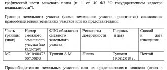
The district court, considering this dispute, proceeded from the fact that the plaintiff and defendant are the owners of neighboring plots of land, and the boundary between their plots was determined by the conclusion of a cadastral engineer.
So there are no violations.
The court also refused to oblige the neighbor to dismantle and move the fence, because this fence is located correctly - on the border indicated by the cadastral engineer. The appeal fully agreed with the decision of colleagues from the district court. So the case reached the Supreme Court. There they studied the verdict of the local courts and said that the decision was incorrect - the norms of the law were violated. These are the rules of law, as explained by the Supreme Court, that should be applied in such disputes.
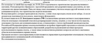
According to the cadastral law, an interested person does not have the right to raise objections regarding the boundaries of a neighbor’s plot, if these are not common boundaries
There is a Federal Law “On the State Real Estate Cadastre” (N 221 of July 24, 2007). This law states that the “location” of the boundaries of land plots must be agreed upon with the so-called interested parties. This is done in cases where “as a result of cadastral work, the location of the boundaries of a land plot is clarified or the boundaries of adjacent plots, information about which is included in the state real estate cadastre, are clarified.”
The Supreme Court emphasizes that the subject of approval under the cadastre law is the determination of the boundaries of one plot, which are also the boundaries of neighboring acres and belong to someone whom the law calls an interested party. At the same time, the Supreme Court reminds, according to the same cadastral law, this interested person does not have the right to express his objections to the boundaries of his neighbor’s plot, if these are not their common boundaries.
Article 39 of the Cadastre Law states that the approval of boundaries is carried out with citizens who own adjacent plots of land. There are exceptions to this rule - they do not require approval of the boundaries of adjacent plots if the acres are in state or municipal ownership and are provided to citizens for lifelong, inheritable possession or permanent (indefinite) use. Land allocated to legal entities that are neither state nor municipal organizations is also not coordinated with neighbors. Also, no approval is required if state or municipal land is provided for indefinite use to a state-owned enterprise.
In our case, the district court established the fact that the dispute was about adjacent plots of the owners. The Law “On the State Cadastre” says that the approval of boundaries at the choice of a cadastral engineer can be carried out by inviting interested citizens to a meeting, or the boundaries can be agreed upon with each individual individually.
The Supreme Court reminded that the places where the boundaries will be drawn are usually agreed upon at a meeting of interested citizens, if we are talking about the territory of a settlement and its borders. But in this case, boundaries are not drawn within the village or town itself.
In our situation, the land survey was carried out by a cadastral engineer, and the customer for the work was one of the neighbors. They both knew very well that there was another one - an adjacent owner. But they did not agree on the border with him. And one more important point - the cadastral engineer established the customer’s border along the actual border, that is, he drew the land where the neighbor’s fence already stood. The Supreme Court emphasized that the cadastral engineer, having drawn the boundary between the plots along the fence, that is, according to the actual land use, could not help but know that this boundary did not coincide with the boundary in the documents.
From this, the Supreme Court concludes that the lack of agreement on the boundaries of the site may indicate the invalidity of the land survey. And he adds that in such disputes about the establishment of boundaries, the local court has the right to evaluate the actions of the cadastral engineer, even without a request from one of the parties. The demands made by the neighbor against the invader fall under Article 60 of the Land Code.
This article of the Land Code talks about such a way to protect one’s interests as restoring the situation that existed before a citizen’s rights to a land plot were violated.
As a result, the Supreme Court overturned all decisions and ordered the case to be reconsidered, but taking into account its clarifications.
By the way
A lawsuit over land could end in big problems. Thus, in Lipetsk, a dispute between neighbors over seized acres resulted in a criminal case against the plaintiff’s son, since the deputy chairman of the regional court was a party to this dispute. The matter turned out to be extremely scandalous. After the indignation of the country's president, he is now being dealt with by the Prosecutor General's Office.
When is it necessary to correct cadastral errors?
If the information about your site is incorrect, this can lead to a number of unpleasant consequences. First of all, these are restrictions on property rights, the impossibility of registering buildings, incorrectly calculated taxes and duties, and disputes with neighbors. Sometimes the owner benefits from the mistakes made, and for this reason he does not take any action. However, sooner or later there will come a time when the error will need to be corrected and it’s good if you have time for this. We recommend correcting errors immediately upon discovery.
Complex cadastral works
I believe that the most correct and effective way to correct massive cadastral errors caused by a change in the coordinate system can be comprehensive cadastral work provided for in Chapter 4.1 of the Federal Law “On Cadastral Activities”.
Unfortunately, legal science does not pay enough attention to this institute. Meanwhile, as stated in Part 2 of Article 42.1 of the Federal Law “On Cadastral Activities”, as a result of complex cadastral work, the location of the boundaries of land plots is clarified and registration errors in information about the location of the boundaries of real estate are corrected. The customer for complex cadastral work is the authorized local government body of a municipal district or urban district. Financing for the implementation of complex cadastral works is carried out from the budgets of the constituent entities of the Russian Federation and (or) the budgets of municipal districts, city districts, including from funds allocated to the budgets of the constituent entities of the Russian Federation in the form of subsidies from the federal budget (Article 42.2 of the Federal Law “On cadastral activities"). Thus, comprehensive cadastral work relieves the financial burden from owners of land plots for which the Unified State Register contains incorrect information.
However, the official website of the unified procurement information system contains about ten procurements, the subject of which are complex cadastral works. According to the procurement documentation, the contract price can be about 450,000 - 3,700,000 rubles, and the cost of cadastral work for one land plot is 2,500 - 6,100 rubles. It is clear that, given the widespread lack of budgetary funds, carrying out cadastral work at the expense of local budgets is not a priority; however, similar work costs private individuals five to ten times more. I believe that in the current situation, it is complex cadastral work that should become the main way to correct cadastral errors caused by a change in the coordinate system.
In the meantime, this tool is rarely used by local authorities, land users who are faced with the described problem can be recommended to solve it at the pre-trial stage, to achieve what they want through negotiations with the involvement of consultants and other specialists, without exacerbating the conflict: court proceedings on disputes over the boundaries of land plots, as shown higher, often turn out to be lengthy and much more costly than one might expect at the beginning.
How much does it cost to fix a registry error?
The minimum cost for correcting a cadastral error by our specialists is indeed 5,000 rubles . In what cases do we work at these prices?
- in the case of surveying public land in your village, if a cadastral error is detected, we will correct it for 5,000 rubles;
- If, during the survey of a plot adjacent to yours, we discovered a cadastral error, we can correct it without opening a new cadastral file, in this case, correcting the cadastral error will cost you 5,000 rubles.
Separately, we note that Rosreestr is very reluctant to correct a cadastral error initiated by the owner himself. Most often, such a case is refused, and the change in boundaries is considered unfounded. The cost of correcting the error in this case is equal to the cost of land surveying - from 10,000 rubles for one plot. At the same time, our specialists will warn about a possible suspension of the case and recommend correcting the error when surveying your neighbors or public land, or going to court.
If it is necessary not only to shift the boundaries, but also to change the area of the site, no matter up or down, the suspension of the case is almost guaranteed. Such a request can only be resolved through court, and even there it is very rare to achieve a positive decision.
It happens that part of a village is placed on the cadastre incorrectly and a large number of areas need to be corrected. Then you can draw up a land surveying project. This is a fairly expensive undertaking, requiring the consent of a large number of participants, but sometimes this is the only way to correctly correct all boundaries on the cadastre, without moving fences installed many years ago.
Our specialists are ready to answer your questions, call us: +7
How to resolve the error
An appeal to correct the error must be preceded by a lot of work to study the real and nominal boundaries of adjacent land plots with the involvement of competent lawyers and cadastral engineers who would help find the optimal and least expensive algorithm for solving the problem.
Thus, a shift in the coordinate system of the boundaries of one land plot may lead to its overlap with the boundaries of an adjacent one, as a result of which the coordinates of the latter will also have to be clarified, and so on. That is, the initiative of one land user often affects the interests of all neighbors and problems grow like a snowball. Thus, as a result of recalculation of coordinates in the Novosibirsk region, a citizen’s land plot turned out to be located within the boundaries of different municipalities, which is unacceptable in accordance with paragraph 2 of Article 83 of the Land Code. This problem created obstacles for the local government in exercising its powers to establish the boundaries of the settlement. To get out of the situation, it was necessary to obtain the consent of the owner to correct the registry error, and subsequently to divide the land plot owned by him into two new ones with their boundaries located on the territory of different municipalities, to which the owner objected. The division was achieved only on the basis of a court decision.
Obviously, the work of making changes to information about the coordinates of several adjacent land plots is lengthy and costly: in addition to the cadastral work already carried out by the applicant, a forensic land survey, legal assistance, payment of state fees, and so on may be required. The question arises, who bears these costs?