An act of approval of the boundaries of a land plot is a document that is part of the boundary plan, containing the signatures of the consenting right holders of adjacent (neighboring) land plots in the boundaries according to the drawing indicated on the back of this act. As mentioned earlier, the purpose of this document is to prevent disputes between neighbors over the passage of the common border of a land plot and subsequent legal proceedings. The act of coordinating boundaries acts as a kind of “agreement” between neighbors on the location of the common border of the plots.
Files for download:
What is the document for?
All land plots registered in the cadastral register must have documented, strictly defined boundaries. This allows territory owners and supervisory agencies to have a clear idea of their size.
In the future, such data will help avoid disagreements with the owners of neighboring plots and state administrative institutions.
In addition, on their basis, tax payments to land owners are calculated correctly and without errors.
Cost of services
You need to understand that defining boundaries is a whole complex of work. Specialists with special equipment go to the site. Naturally, you will have to pay for these services. Practice shows that many geodetic companies do not charge fees for any individual services. It’s just that a standard fee is charged for the entire range of work. Today its size is 5-7 thousand rubles. Certain factors influence the cost:
- the status of the company you are contacting;
- locality;
- what category does the land belong to;
- area and shape of the site.
However, you need to understand that the fixed cost is taken only for standard rectangular plots. As a rule, their size is 8-10 acres. Typically, such areas are used for summer cottages. If the plot is too large you will have to pay extra. You also need to take into account that if the land has a complex shape, payment will be calculated based on the number of turns of the boundaries.
There are lands that belong to the elite category. This applies to territories located near Moscow and St. Petersburg. Here the cost of measurements is calculated separately. Practice shows that the cost of geodetic work in these regions is more than 30 thousand rubles.
Who is entrusted with the function of clarifying the boundaries of land zones
The responsibility for monitoring the extreme points of land plots is assigned to cadastral engineers. These are highly qualified specialists who have the necessary professional knowledge and have the appropriate government certificates.
The list of powers of cadastral engineers includes:
- the right to familiarize yourself with documents certifying the identity of land owners;
- the right to inspect title papers;
- the opportunity to provide land owners with a boundary plan and give the necessary explanations on it;
- establish the boundaries of land plots subject to approval;
- carry out the actual coordination activities.
Grounds for cancellation
Only the owner himself has the right to challenge the boundaries by going to court. Usually the basis for this is:
- untimely notification of the boundary establishment procedure;
- drawing up an act with violations both technical (misprints, typos) and legal;
- provision of false information about the boundaries of the site.
When preparing such official documents for a land plot as a cadastral passport or a certificate of ownership, land surveying should be carried out with the establishment of exact boundaries. For this procedure, it is necessary to obtain the consent of all neighbors from adjacent areas.
This connection is formalized by a document of a certain form, which is called an act of coordination of boundaries. The entire approval procedure can only be carried out by a cadastral engineer. The documents that are necessary for its implementation are sample notifications for sending by mail and for submission to the media, an act of border approval.
How does approval take place?
The process of coordinating the extreme points of the sites can be carried out in one of two options. The first implies that the stakeholders are several people at once. The second involves individual coordination with one neighbor.
A corresponding notification is sent to each of the parties directly related to the case a month before the event. It must be handed over only against signature.
Electronic notification or publication in the media is also permitted. True, these two methods do not guarantee that the information will reach the recipient.
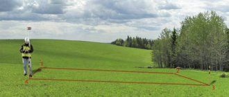
On the appointed day, the cadastral engineer takes measurements of the plots and installs special identification poles at the required points. They must contain information about the number and date of installation. Supervision over the condition of these pillars rests with the land owners. In case of damage or loss, the violator may be subject to administrative punishment in the form of a fine.
The entire process is recorded in a special approval act. This also includes information about whether the participants in the process agree with the established boundaries or not.
The legislative framework
The legislative basis for conducting land surveying and coordinating boundaries with the owners of adjacent territories is defined in the Federal Law “On Cadastral Activities” No. 221 of 07/24/2007, Federal Law 218 of 07/13/2015. Article 39 of this law describes the procedure for establishing boundaries, indicates the subject of approval, the parties entitled to participate in this procedure, and methods of notification of upcoming work.
Article 40 provides the main provisions on the act of approval: how it should be drawn up and in what case it is considered valid.
Features of drawing up an act
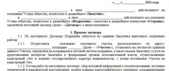
Today there is no generally applicable, standard form for the act of agreeing on the boundaries of a land plot, so it can be written in any form. The only thing that needs to be taken into account is that the sequence of its content meets certain standards for compiling this kind of documentation. This means that the form should be divided into three parts:
- beginning is the name and number of the document;
- main section - information about the site, the boundaries of which are being agreed upon;
- conclusion - the decision made (whether they were agreed upon or not) and the signatures of the parties.
The act can be written manually or typed on a computer. For a printed document, an ordinary blank sheet of paper of any convenient format is suitable (A4 is mainly used).
The document must be made in a number of copies equal to the participants in the approval procedure - one for each interested party.
Basic moments
Coordination can be carried out not only at the initiative of the land rights holder. The following additional reasons for carrying out this procedure can be identified:
- identification of a registry error by Rosreestr officials, as a result of which additional cadastral work is required;
- presentation of claims by one or more owners of plots whose boundaries need to be agreed upon for violation of their rights by previously carried out land surveying;
- division or allocation of a land plot, as a result of which a dispute may arise between the copyright holders of one object.
Before approval, you must first find out the existing boundaries of the site by cadastral number, and each land owner must take part in the agreement.
Unlawful exclusion of at least one of the owners from this procedure will entail a violation of his rights and will provide an opportunity to challenge the act and boundary plan in court.
Sample act of approval of the boundaries of a land plot
- First, in the middle of the document, write its name and put a number (if necessary).
- Next, the cadastral number of the plot, the boundaries of which are being agreed upon, its area is indicated, and information about the owner is also given.
- After this, information about the approval is entered into a special plate:
- a sign indicating the demarcation is indicated;
enter the number of the adjacent plot and information about its owner;
- a note is made if the agreement took place with a person acting under a power of attorney;
- signature of the owner of the neighboring plot.
- Further, the act must include information that there are no disagreements regarding the agreement between the owners of neighboring plots. If there were any, this must also be indicated and at the same time write down what decision was made in this regard (trials in court, voluntary additional land surveying, etc.).
- At the end, the document is signed by all participants in the approval procedure.
You can add any other additional information to the table as needed.
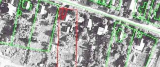
What is a land survey document?
The act of approval is the basis for establishing the exact contours of the property and the size of its area. This paper is intermediate in carrying out geodetic work and drawing up a boundary plan. Upon completion of the work, the survey report is stored in the survey file.
In essence, the act of approval and the act of land surveying are one piece of paper, on which, on one side, there is an approval of the boundaries of the land on a special form, and on the other, a drawing of this site with all the data about it.
After the preparatory stage, which is associated with collecting documentation, concluding an agreement with a company to perform geodetic work and notifying land owners, the land surveying stage begins.
When carrying out work at the very beginning, the specialist approves the contours of the site. During this procedure, all persons interested in the correct design of boundaries must be present. Therefore, you need to understand that when carrying out land surveying, you will need to obtain the consent of all neighbors .
Representatives of local authorities or municipalities are also present during the procedure. Also, if measurements are carried out on the territory of a gardening partnership, then the presence of the chairman or representative of the board of the partnership is mandatory.
Are you just planning to carry out the land surveying procedure? Wondering how much the whole process will cost?
Rules for calculating costs and the influence of various factors can be found here!
Refusal to sign
When a dispute arises between neighbors and they refuse to sign the land survey agreement, there are several typical reasons.
The most common causes of conflicts:
- The boundaries of adjacent territories intersect;
- The cadastral engineer or geodetic specialist made a mistake when determining the boundaries;
- Incorrect information has been entered into the registry database;
- The presence of the fact of unauthorized seizure of the site or its part;
- Inconsistencies with previously issued survey documents.
In order not to aggravate the situation, it is advisable to find a compromise in such disputes. If this is not possible, the case is sent to court, where it will be considered in accordance with the norms of the Land Code of the Russian Federation.
It is important that the dissenting neighbor put his objections in writing. This document must be attached to the boundary plan. It is important to compare cadastral plans and property passports. Data from them are available in the state archive. It is also necessary to find out what area the objects previously had, where their boundaries were and pay attention to the history of the transfer of ownership of real estate.
Options for approval
The person interested in cadastral work determines the method of carrying out the procedure: with or without establishing the boundaries of territories on the ground. The information is reflected in the act. Regardless of the customer’s requirements, the procedure is not carried out on site if the subject of approval is:
- forest areas;
- agricultural lands that are used by small peoples of the Russian Federation (Siberia, the North, the Far East);
- areas whose boundaries are defined by linear objects located on the territory;
- specially protected areas;
- land sectors, the spatial limit of the distribution of rights to which is established by natural objects or objects of artificial origin.
Expert opinion
Korolev Denis Igorevich
Lawyer with 10 years of experience. Specialization: civil law. Member of the Bar Association.
The cadastral engineer has the right to coordinate boundaries individually or at a meeting of interested parties. A notice of the event is prepared.
The document is sent by letter with notification, handed over personally against signature. It is permissible to publish a notice, for example, if there is no information about the address of any interested person.