“Practice shows that the lack of precisely defined boundaries is the cause of most conflicts between owners of adjacent land plots. But if you carry out land surveying, the exact boundaries of your site are entered into the Unified State Register of Real Estate. In this way, you will protect your rights and minimize the occurrence of land disputes,” Rosreestr explained.
The presence of clearly established boundaries allows you to carry out any operations and transactions with the site without unnecessary problems. In addition, land surveying will help correct possible errors, including in information about the actual area used.
“Incorrect information about the area of a plot may cause an incorrect determination of its cadastral value and, as a consequence, an incorrect determination of the amount of land tax,” the department added.
How to find out whether the boundaries of a land plot are included in the Unified State Register of Real Estate?
All necessary information is contained in the extract from the Unified State Register. If the register does not contain the necessary information, the extract will contain a special statement.
You can obtain an extract using electronic services on the Rosreestr website, as well as on the website of the subordinate Federal State Budgetary Institution FKP Rosreestr.
You can also use the “Public Cadastral Map” (PCC) service. The easiest way to find a specific object on it is by address. If in the object description window there is o or the area is indicated as declared, it means that the boundaries of the site have not been established.
Cases of clarification
The basis for clarifying the boundaries will be the lack of information about the coordinates of the land plot in the USRN data. This problem may arise when purchasing a plot that has a "previously listed" status.
This status means that the rights to the land plot were registered according to a previously existing procedure that did not involve recording reliable data in the register. Or, the previously carried out surveying was carried out using outdated measuring instruments and coordinate systems, which are no longer used due to unreliability. Modern technologies will make it possible to determine the location of the border with centimeter accuracy, but this was not always the case.
The need to clarify boundaries may also arise in the event of cadastral work being carried out by neighbors or complex cadastral work in the SNT, or a land dispute arising about the boundaries of a plot, when it becomes an inheritance, and so on. The lack of clearly defined boundaries is one of the most common causes of conflicts between owners of adjacent land plots.
Alexander Vasiliev
Lawyer
The Ministry of Economic Development issued a letter dated November 6, 2021 No. 32226-VA/D23i, which contains a number of instructions on clarifying the boundaries of land plots. In particular, it indicates cases when it is necessary to carry out the procedure for clarifying boundaries, including the identified cadastral error.
If an error is identified in the results of previously carried out land surveying work, the owner of the site will have to order new cadastral work. Previously completed work will be considered invalid.
In addition, the property owner may use the boundary procedure to slightly increase or decrease the documented area of the property. If the plot actually occupies a larger area than indicated in the documents, establishing its actual boundaries will increase the price of the property if it is sold. And vice versa, if the plot is smaller than stated in the documents, the owner overpays land tax for it.
It should also be taken into account that the illegal (i.e. not confirmed by documents) use of land outside the boundaries of the land plot constitutes an administrative offense in accordance with Art. 7.1. Code of Administrative Offenses of the Russian Federation. The fine for this from an individual is up to 10 thousand rubles or up to 1.5 percent of the cadastral value of the land plot.
The lack of fixed boundaries of a plot may become an obstacle to its successful sale. Banks are reluctant to provide mortgages on incorrectly listed properties, which can reduce options for the seller.
How to clarify the boundaries of the site?
Land surveying is carried out by cadastral engineers. They are the ones who carry out all the necessary measurements and calculations. By law, every cadastral engineer is required to be a member of a specialized self-regulatory organization (SRO). SROs monitor the activities of their members and consider complaints from applicants if cadastral work was carried out with violations.
You can obtain information about a specific cadastral engineer on the Rosreestr website in the “State Register of Cadastral Engineers” section. It contains information about his special education, qualification certificate, and confirmation of his membership in the SRO. In addition, using the electronic register of cadastral engineers, you can find out about the results of a specialist’s professional activities.
A cadastral engineer visits the site and takes the necessary measurements. If there is a fence, then measurements are taken along it. If there is no fence, it is better to mark the corners of the area with pegs in advance. After reviewing the measurement results, the boundaries of the site must be agreed upon with the owners of adjacent plots.
After this work, the cadastral engineer draws up a boundary plan.
What is boundary clarification?
This procedure is an establishment of the actual position of a site on the ground with the determination of its exact coordinates in the corresponding modern system. It includes:
- actions of a cadastral engineer carrying out geodetic work (surveying) of a site on the ground for the purpose of determining where the boundaries of the site lie;
- subsequent recording of new data on the land plot in the Unified State Register of Real Estate (USRN).
What is the difference between surveying and clarifying boundaries
Land surveying is a complex of geodetic works, the purpose of which is to establish the boundaries of the site and their location on the ground. Land surveying is carried out by the efforts of a cadastral engineer. His responsibilities include establishing the coordinates and area of the land plot and coordinating its boundaries with the owners of neighboring land plots. The result of this work is a boundary plan.
This procedure is carried out both during the initial creation (formation) of a land plot, and when clarifying the boundaries of an existing plot. Thus, land surveying represents the work that is necessary to clarify the boundaries.
What documents are needed?
Clarification of the boundaries of a land plot is carried out on the basis of information contained in the title document for the land plot. Additionally, information specified in the documents that determined the location of the boundaries of the site when it was formed can be used.
If there are none, the clarification can be carried out in accordance with the boundaries that have existed on the ground for 15 years or more and are fixed using natural objects or objects of artificial origin, which make it possible to determine the location of the boundaries of the site. This may require:
— situational plans contained in technical passports of real estate objects (located on a land plot), which are prepared by the bodies of state technical accounting and technical inventory (BTI);
— forest management materials;
— planning and cartographic materials available in regional authorities of architecture, construction and housing, local authorities;
— documents on territorial planning of municipalities;
— projects for the organization and development of the territory of dacha, garden and vegetable garden non-profit partnerships.
The procedure for changing the configuration of a land plot through the court
Changing existing property boundaries often causes a lot of controversy. If the owners of neighboring plots object to the changes, the dispute will have to be resolved in court. To do this, you need to file a corresponding statement of claim in court.
The claim must indicate the name and details of the parties to the dispute, all the circumstances of the case, information about the site, and the rationale for changing the boundaries. Such disputes are not easy, so when drawing up a claim and defending your position in the process, it is better to use the help of a lawyer.
Based on the results of consideration of the claim, the court may decide to change the configuration of the existing site. And this decision will already be the basis for making appropriate changes to the land documents.
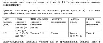
How to coordinate the boundaries of the site with the neighbors?
The cadastral engineer will also help in coordinating new boundaries with the owners of adjacent plots: he must send them notifications by postal or e-mail; individual approval is also allowed.
If they cannot be found, the cadastral engineer publishes a notice in the local press. The addressee will be considered notified even if he does not read this announcement.
Rights holders of adjacent plots must confirm their consent by signing an agreement document. If they do not agree, they can forward their objections to the cadastral engineer. Objections must be recorded in the act of approving the location of the boundaries of the land plot, and also attached to the boundary plan.
Next, the documents must be submitted to Rosreestr. If there are justified objections, registration and registration activities will be suspended, and neighbors will have to resolve disagreements in court.
Legal grounds and legislation
Most issues related to the procedure for clarifying the boundaries of a land plot are regulated by:
- Federal Law No. 218-FZ “On State Registration of Real Estate” dated July 13, 2015 (Article 43); And
- Federal Law No. 221-FZ “On Cadastral Activities” dated July 24, 2007.
Alexander Vasiliev
Lawyer
In addition, there are many instructions and clarifications from Rosreestr and the Ministry of Economic Development regarding the procedures for clarifying boundaries and performing cadastral work. These clarifications are used by cadastral engineers and rights registration authorities in their activities.
How and why is land surveying carried out?
Rosreestr recommends that owners of land plots whose boundaries are not defined carry out land surveying and enter updated information into the Unified State Register of Real Estate (USRN).
Why is it important? Currently, the law does not provide for any restrictions for the lack of land surveying. Everything is done entirely on a voluntary basis. If the owner does not have a boundary plan, this will not serve as a basis for limiting rights.
At the same time, it must be borne in mind that land surveying is guaranteed to save owners from many legal problems. Practice shows that the lack of precisely defined boundaries is the cause of most conflicts between owners of adjacent land plots. But if you carry out land surveying, the exact boundaries of your site are entered into the Unified State Register of Real Estate. This way you will protect your rights and minimize the occurrence of land disputes.
The presence of boundaries allows you to carry out any operations and transactions with the site without unnecessary problems. For example, it will be easier to sell it, because buyers are unlikely to want to purchase a plot without clearly defined boundaries.
Clarifying the boundaries will help correct possible errors, including in information about the actual area used. It may differ from what is indicated in the USRN information. In addition, erroneous information about the area of a plot may cause an incorrect determination of its cadastral value and, as a consequence, an incorrect determination of the amount of land tax.
Moreover, if the owners decide to divide the land plot, then this is also possible only if there are established boundaries.
How to find out whether the boundaries of a land plot are included in the Unified State Register of Real Estate?
All the necessary information is contained in the extract from the Unified State Register of Real Estate about the main characteristics and registered rights to the property. If the register does not contain the necessary information, the extract will contain a special statement.
You can obtain an extract using electronic services on the Rosreestr website, as well as on the website of the subordinate Federal State Budgetary Institution FKP Rosreestr.
You can also use the “Public Cadastral Map” (PCC) service. The easiest way to find a specific object on it is by address. If in the object description window there is o or the area is indicated as declared, it means that the boundaries of the site have not been established.
How to clarify the boundaries of the site?
Land surveying is carried out by cadastral engineers. They are the ones who carry out all the necessary measurements and calculations. By law, every cadastral engineer is required to be a member of a specialized self-regulatory organization (SRO). SROs monitor the activities of their members and consider complaints from applicants if cadastral work was carried out with violations.
You can obtain information about a specific cadastral engineer on the Rosreestr website in the “State Register of Cadastral Engineers” section. It contains information about his special education, qualification certificate, and confirmation of his membership in the SRO. In addition, using the electronic register of cadastral engineers, you can find out about the results of a specialist’s professional activities.
A cadastral engineer visits the site and takes the necessary measurements. If there is a fence, then measurements are taken along it. If there is no fence, it is better to mark the corners of the area with pegs in advance. The next stage is familiarization with the measurement results. Next is the process of coordinating boundaries with the owners of adjacent plots.
As a result of the work, the cadastral engineer prepares a boundary plan containing information about the characteristic points of the border of the land plot.
What documents are needed?
The cadastral engineer will not be able to establish the boundaries of the land plot as the owner wants. To carry out the work, documentary evidence will be required that the site has been allocated in this particular location and in this exact area.
According to current legislation, clarification of the boundaries of a land plot is carried out on the basis of information contained in the title document for the land plot. Additionally, information specified in the documents that determined the location of the boundaries of the site when it was formed can be used. If there are none, the clarification can be carried out in accordance with the boundaries that have existed on the ground for 15 years or more and are fixed using natural objects or objects of artificial origin, which make it possible to determine the location of the boundaries of the site.
Additional explanations are provided at the link. Documents defining the location of the boundaries of a land plot during its formation and their existence for 15 years or more may be:
- situational plans contained in technical passports of real estate objects (located on a land plot), which are prepared by the bodies of state technical accounting and technical inventory (BTI);
- forest management materials;
- planning and cartographic materials available in regional authorities of architecture, construction and housing, local authorities;
- documents on territorial planning of municipalities;
- projects for the organization and development of the territory of dacha, garden and vegetable garden non-profit partnerships.
How to coordinate the boundaries of the site with the neighbors?
It is not enough to clarify the location of the boundaries of the plot - it is necessary to coordinate it with the rights holders of adjacent, that is, neighboring plots. The cadastral engineer must send them the relevant notices by postal or email, and approval on an individual basis is also allowed.
If they cannot be found, the cadastral engineer publishes a notice in the local press. The addressee will be considered notified even if he does not read this announcement.
Rights holders of adjacent plots must confirm their consent by signing an agreement document. If they do not agree, they can forward their objections to the cadastral engineer. Objections must be recorded in the act of approving the location of the boundaries of the land plot, and also attached to the boundary plan.
Next, the documents must be submitted to Rosreestr. State registrars will conduct a legal examination, and if everything is in order, then information about the boundaries of the site will be entered into the Unified State Register of Real Estate. If there are justified objections, the rights registration authority will suspend registration and registration activities, and neighbors will have to resolve disagreements in court. The cadastral engineer who carried out the land survey may also be involved in the case as a third party.
Resolving a land dispute at the stage of boundary approval will eliminate the need to go to court. Litigation regarding the establishment of land boundaries is one of the most complex and lengthy.
Who can apply?
An application for changing the boundary can be made from certain persons who have grounds for such actions.
Such persons include citizens, as well as individuals or legal entities who have ownership rights to the plot in relation to which the question of clarifying the passing boundary arises.
Also, those who are users of the allotment with the subsequent transfer of ownership of it may also have the right to change indicators.
However, in such a situation, most areas do not even have a boundary plan yet, so we will not be talking about changing the boundaries, but about establishing them.
Where can I order a service to change the boundaries of a property?
Such services are provided by specialized offices - geodetic (or cadastral) companies. Their staff includes cadastral engineers and surveyors. The activities of such organizations must fully comply with the Federal Law “On Cadastral Activities”.
As this normative act states, a cadastral engineer is a person who has a special education and who is part of the corresponding SRO of the same specialists. He must have a license to carry out cadastral and geodetic work.
Otherwise, the document issued based on the survey results will not be valid. And this will lead to the need to contact another cadastral engineer again.
Therefore, the customer of the services is recommended to request documents confirming the status from the engineer, after which they can enter into an agreement for the provision of services and set a day for visiting the land property to carry out the procedure for changing boundaries.
If boundaries overlap
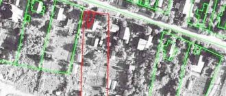
Until 2011, land boundaries were determined very conditionally. As a result of the emergence of new land surveying rules, the boundaries of land plots began to be more accurately tied to the new geodetic coordinate system. As a result, the owners of many land plots were faced with the problem of imposing boundaries.
Overlap occurs when neighboring areas, according to previously executed documents, border, but in reality, when the boundaries are clarified (i.e., when they are transferred to the current coordinate system), it turns out that one area partially overlaps the other.
Alexander Vasiliev
Lawyer
You can solve a problem with such a cadastral error voluntarily. But in practice, none of the neighbors wants to give up part of their land, that is, a dispute arises between neighbors. In this case, it is necessary to go to court with a request to correct it. Based on the results of the consideration of the case, the court will oblige to correct this error, and the newly defined boundaries will be registered by Rosreestr.
Changing the size and configuration of the site
If there is no dispute between neighbors regarding the boundaries between their land plots, the owner can simultaneously increase the area of land owned by him. The increase in the site when clarifying the boundaries cannot exceed 10% of its existing area.
It is also necessary to take into account the requirements of legislation establishing the minimum and maximum boundaries of land plots of certain categories.
In addition to the area, during the clarification of boundaries, a slight clarification of the configuration (i.e., outlines) of the land plot may occur. It is acceptable if the total increase in area is within the permitted limits. The Ministry of Economic Development issued the corresponding clarifications in response to questions asked by citizens.
The article provides general information about the content of the legislation. If you have any questions, ask your lawyer.
If the land is owned, but there is no land survey
Often there may be a situation in which a certain person has title to land, but there is no boundary plan for it.
This may be due to the peculiarities of the transfer of ownership of the land, as well as the period of time in which this occurred - perhaps due to the lack of certain regulatory standards, the registration of the site occurred without action to determine the actual boundary .
In this case, the owner must understand that when trying to sell a plot, register a deed of gift for it, build a real estate property, etc., he will be faced with the need to provide data on the passing boundaries of the plot.
In such a situation, you should not hesitate , since establishing boundaries is a fairly lengthy procedure and if there are disputes regarding them, drawing up a boundary plan can take up to 6 months.