Pravozhil.com > Real estate registration > Land registration > How to change the boundaries of a land plot - basic rules and nuances
Any land plots have such individual characteristics as area, configuration, exact coordinates and boundaries.
However, for various reasons, the actual and previously established boundaries may not coincide. In this case, the question arises about their clarification. We'll talk about how to change the boundaries of a land plot below.
When is it necessary to change the boundaries of a land plot?
There are several cases when it is necessary to carry out land surveying. These include:
- Erroneous initial change of site boundaries. This happens if the surveying company made mistakes and inaccuracies. Usually such manipulation is carried out again free of charge. The land owner only makes a second request.
- Natural blurring of boundaries. Over time, boundaries may disappear. A neighbor has moved the fence to your property a couple of centimeters, or the outdated documentation does not clearly show the area of the property.
- In connection with the statement of neighbors. If the neighbors filed a statement that they doubt the correctness of the measurement or noticed that you have taken over the area of someone else's plot. If there is an unauthorized increase in the plot by one of the neighbors, this must be proven.
- An application was received from the owner of the site. This issue is resolved if there is a need to separate or combine two adjacent areas. This is possible when buying or selling.
- In order to clarify the boundaries. If there is a discrepancy in land surveying: the documents indicate one thing, but on the ground it is actually another.
How to remotely register a property
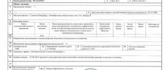
The official website of Rosreestr provides the possibility of remote access for the purpose of cadastral registration of real estate, including land plots. To complete the entire procedure, you must carry out cadastral work to survey the land plot and upon completion receive a survey plan. It is executed in digital XML format with an electronic signature of the specialist who carried out the work.
For remote cadastral registration, you must adhere to the following steps.
1. On the main page of the portal, in the “Electronic Services” section, select the “State Cadastral Registration” section.
2. In the “Submit an application for the Civil Code” window that opens, read the requirements for the documents provided. Indicate the type of property (1), its location (2), the form for obtaining the document (3), the form for providing the refusal (4). After that, enter the security code (5) and click “Go to applicant information” (6).
3. In the form that appears, fill in the fields indicating the type of applicant (1), identification and passport data (2), contact information (3), consent to data processing (4), confirmation of information (5) and click “Go to attached documents” (6).
4. In the “Submit an application for the State Civil Code” window, provide information about the document being sent (1), attach the boundary plan in an electronic XML file archived in zip (2), click “Save” (3).
5. Attach the remaining documents using the above method, and then confirm sending the documents to Rosreestr for review.
General provisions on how to register a plot of land for cadastral registration are indicated on the State Services portal. Such information is located in the appropriate section.
Basic Concepts
Changing the boundaries of a land plot is a set of measures aimed at clarifying the size of the territory and, if necessary, making changes to the current documentation. This is documented only if the territorial zone actually shifts in one direction or another.
Simply entering updated data is not enough; it is necessary for the government agency to record the declared changes. To do this, the document with adjustments is submitted to the state body - Rosreestr, which directly records the changes made and approves the declared data with a seal.
A document with measured boundaries is submitted to the branch of Rosreestr at the location of the limited territory.
Important! Despite the fact that Russian legislation provides permission to reduce and increase the boundaries of the allotment, it must be taken into account that if the margin of error is allowed to be exaggerated, then the entered information must be correctly documented.
When changing the boundaries of a land plot, all data must be entered immediately onto a paper plan Source ndv.ru
When they can refuse
Almost no one is refused at the time of receiving documents, so it is important to monitor the process of the registrar’s work and be ready to provide additional documents. Refusal is possible in the following cases:
- The information from the application and documents does not correspond;
- There is no written consent of third parties if the redistribution of land affects their interests;
- The annexed plot is withdrawn from land circulation or limited;
- Bidding has been announced for the plot;
- The site contains real estate objects owned by citizens, state or municipal bodies;
- The area of the plot is 10% larger than the main one;
- The annexed land is subject to independent formation;
- There is at least one discrepancy in the layout.
There is no provision for refusal due to the lack of information about the plot in the unified real estate register. It is important to identify such a situation in advance in order to carry out cadastral work in a timely manner and apply for registration of the cut-off plot. Only after completing this procedure can you annex the territory to your land. In most cases, a documented refusal is issued with a precise indication of the reason. If it can be corrected, resubmission of the application is allowed.
Registration of extensions is an ideal solution not only for the owner, but also for the authorities. But this will lead to an increase in the cadastral value of the site and a slight increase in land tax.
Thus, increasing the plot is possible by adding additional area. But it is important to comply with the maximum permissible magnification rates in force in a particular region. Having collected all the documents and knowing the procedure, you can unite the plot in a short period and obtain legal ownership.
Important in the procedure for changing boundaries
Changing the boundaries of a land plot has its own characteristics, which consist in the following two ways:
- Without making adjustments to the area of the territory. It involves drawing boundary lines on the ground with clarification of all turning angles without shifting the sides of the site. There may be some redistribution of land plots with a shift, during which the area of the plot remains the same. In this case, the boundaries can move both in length and width.
- With a change in area. This is possible when merging, dividing, or allocating a separate share of the plot. As a result, after the boundaries are changed, a new area of the territory will appear. In some cases, one area is divided into two or three parts. This usually happens when controversial issues arise between the heirs of a share or local area. In the case of the allocation of a certain share, the plot from which a certain area was removed remains the main one, and the new one (share) is considered secondary.
Please note that a change in the boundaries of a land plot can be ordered by the direct owner or a person who is dissatisfied with the seizure of the area. This can be either an individual or a legal entity.
Boundary measurements should be carried out exclusively by professionals in the field of geodesy Source 2gis.ru
How to change the boundaries of a site?
Changing (clarifying) the contour of a land plot is a procedure for documenting deviations from a previously drawn up boundary plan, which can be carried out in two ways.
The first is a revision of the configuration of the contour line that defines the site, but while maintaining its area. Thus, in one place part of the area decreases, in another, accordingly, it increases. But the total area indicated in the cadastral passport remains unchanged. The second option is a procedure for changing (clarifying) the boundary with a change in both the configuration of the boundaries and the total area of the allotment. It can be carried out when correcting an error that was included in cadastral registration, or when adding a certain ownerless territory, but not a larger area, which is defined in the Land Code. Otherwise, it is necessary to carry out land surveying of a new plot separately (as, for example, when purchasing).
Where to start the land surveying procedure
To begin changing the boundaries of a land plot, you need to go through several stages. First of all, you should submit an application in the appropriate form to the cadastral department authority (this may be the local cadastral chamber). In this case, it is necessary to attach a certain list of documents:
- the statement itself;
- a document that confirms ownership of the land plot (deed of gift, certificate of inheritance);
- extract from cadastral registration;
- situational plan (indicating all objects present on the territory);
- a document that authorizes changes to the cadastre;
- identification document of the applicant (passport).
Next, a bilateral agreement is concluded between the owner and the contractor (geodetic company), in which both parties undertake to comply with the established rules and complete the work within a strictly established time frame.
Upon completion of the measurement work, the signature and stamp of the performing company must be affixed. Source 90percentrule.com
In case the boundaries are measured again, then it is also necessary to provide a justification that explains that it is necessary to carry out the survey work. It could be:
- administrative act;
- the court's decision;
- decision of Rosreestr.
It is not possible to simply check the boundaries of the site if desired.
Refusal
In some cases, the owner may be denied the service of making changes to the cadastral passport. There may be several reasons:
- an incomplete package of documents has been collected;
- incorrect execution of copies of documents;
- the power of attorney has expired;
- execution of a power of attorney with errors;
- making changes is contrary to current legal provisions.
If the authorized body refuses to correct a technical error, then there must be appropriate grounds for this. Among them:
- the detected deficiencies are not technical;
- the presence of errors has not been confirmed;
- the submitted papers do not contain the information that is necessary for the authorized bodies to correct the technical error.
In order to avoid refusal, you must fill out the application in person and submit the application yourself. And this method has several advantages. Firstly, the citizen will save his money. Registration of a power of attorney with a notary is an expense. Secondly, if documents are sent by mail, then you must pay the cost of postage. Thirdly, if an error is discovered in the application, the person can correct it on the spot. But if the documents are submitted via mail, then this option is not available.
If, in the opinion of the citizen, he did everything correctly, but received a refusal from the authorized bodies, then it is worth submitting a second request. If they refuse this time, then you need to file a lawsuit in court. And demand that appropriate adjustments be made.
Some nuances
You need to understand the difference in three procedures: making changes to the cadastral passport, registering a real estate property, correcting existing shortcomings and errors.
As for the removal of real estate from the cadastral register and its re-registration, these situations arise in the process of global redistribution of real estate, when several objects take part in the process. If a person needs to make minor changes to the cadastre, then we are talking about minor alterations in real estate. For example, if the area of a residential building located on a plot of land has increased by 10 sq.m., or the dimensions of the plot itself have changed. If the owners of the land plot decide to attach a residential building to the house, it requires commissioning, then the first building is removed from the cadastre, and the entire complex is re-registered. As for correcting minor defects, errors, and blots, this is a procedure separately regulated by law. The adjustment occurs at the request of the cadastral authority, at the request of the owner himself, or by court decision. That is, three initiators can demand correction of errors in the cadastral passport. The last option occurs if the applicant was refused, he decided to seek protection of rights and legitimate interests in court. In this situation, based on its decision, the authorized body is obliged to correct the error. And do it in 5 days.
Stages of boundary changes
In most cases, the entire land surveying process, together with the approval of the site plan, is officially carried out for at least three months. This period is enough to thoroughly double-check everything and clarify the boundaries of the site. To measure, all actions are performed in several stages:
- Preparation. This process begins with concluding an agreement with a geodetic company. A list of owners of adjacent plots is compiled, and a work plan is prepared in relation to the applicant’s land.
- Field work. This stage includes a geodetic survey, during which the area of the site is clarified and boundary signs are installed. All measuring work is carried out using professional equipment; relief features, soil type, and other features that are recorded on the site (depression, hill, presence of a natural or artificial reservoir) must be indicated. All recorded objects must be recorded on a plan on paper.
- Conclusion. This is the last stage, which includes the processing of the received information by specialists of the geodetic company, they also conduct a consultation with adjacent owners and clarify whether they agree with the measurements taken. Only after this is all the data transferred to an official document (cadastral passport), the adjustments made are confirmed by the seal and signature of the executive body.
All stages are carried out in strict sequence. As for coordination with neighbors, resolving this issue can take a long time. This process can also be divided into several step-by-step actions.
When measuring the boundaries of a local area, all types of objects present on it are taken into account Source megaprovokator.ru
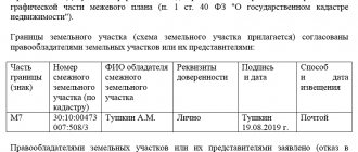
Coordination with neighbors: important features
It is clarified that coordination with the owners of adjacent plots may take some time. It consists of several step-by-step actions:
- Neighbors receive a notification from the geodetic company, which is sent to the place of registration or residence. It can be sent by email, registered mail, published in a local newspaper (usually this option is advisable if the exact location of the owner of a neighboring plot of land is unknown) or the document can be issued in person against signature.
- The notice specifies the exact date on which the owner of the adjacent plot must appear at the geodetic company or wait for a representative of the company at home. During a meeting between the two parties, the engineer provides a plan of the measured area and clarifies whether the neighbor agrees with the changes. Typically, these meetings are held with at least three neighbors whose plots coincide with the one on which the survey was carried out.
- A day is set aside on which representatives of the company answer all questions from neighbors and carry out explanatory work. As a result, none of the adjacent owners should have doubts about the legality of the actions taken to change the boundaries.
- On the reverse side of the plan depicting the boundaries of the land plot, an act is drawn up, which indicates information about adjacent plots, their features are prescribed, and the exact area must be indicated.
- At the last stage, all neighbors who agree with the geodetic work carried out sign the act, after which the document is filed. The passports of persons who leave their signature in the cadastral documentation must be checked.
It is noted that a representative of the owner of an adjacent plot can also sign (the owner is sick, is abroad, other reasons), but only on the condition that he has an official power of attorney to carry out such activities.
Important! A drawing is a mandatory document, without which it is impossible to draw up an act and sign it. A document without graphic data can be easily challenged in court.
An example of an ideal site plan indicating all its features Source housevrn.ru
Plan of a land plot in the open steppe without accompanying objects Source zemvopros.ru
Clarification by court decision
Conflict situations with neighbors regarding the coordinates of borders often lead to litigation. As a result of the trial, a decision is made to clarify the boundaries with a reduction in the area of the defendant's plot in case of unauthorized seizure of part of the neighbor's plot by moving the actually allocated boundaries. If the area of the plot is reduced after clarification of the boundaries by more than 1/10 of the original value, a justification for the clarification from the cadastral engineer on a separate sheet is attached to the boundary design for the change.
An appeal to the court may follow after a violation of the rules for agreeing to clarify boundaries. All interested parties are involved in the approval procedure, including:
the location of the borders can be determined by any documents issued
- initiator - land owner;
- neighboring land users;
- cadastral engineer responsible for measurements.
Based on the results of the clarification work, a boundary plan is drawn up, which has graphic and text parts. The graphic schematically depicts the boundaries of the site with coordinates, the text is intended for calculation justification for clarifying the boundaries, information about the allotment, category of land and type of intended use. The act of approval of boundaries is drawn up on the reverse side of the graphic part of the boundary plan and certified by the signatures of interested parties. If the boundaries are agreed upon without the presence of all participants, then the latter have the right to put forward demands in court to re-clarify the boundaries.
Changing boundaries after surveying
The question often arises of how to change the boundaries of a land plot after land surveying. This is possible in several cases: if the deadline established by law has passed or there are dissatisfied persons, or land survey documents were signed without their consent.
At the same time, no one except the owner can make a repeated application to the geodetic company. The owner will only need to provide evidence that the boundary change procedure is necessary. Find out what the justification may be in the section above.
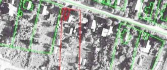
The boundaries of a rectangular area on paper are highlighted with a red line if they were measured again Source: measurezemzem.rf
Finally
The boundaries of existing land plots may change. However, to officially establish new boundaries, a certain procedure must be followed.
At the same time, you need to be prepared for the fact that the owners of neighboring plots will express their objections to this matter.
You can learn about the practice of resolving disputes about establishing the boundaries of a land plot by watching the video:
See also Phone numbers for consultation Nov 26, 2021 kasjanenko 1215
Share this post
Discussion: 2 comments
- Faina says:
04/22/2019 at 05:14please let me know where there are standard agreement forms
Answer
- 5master5 says:
04/28/2019 at 11:55
I think that while the dacha amnesty period has been extended, we should definitely take advantage of securing the boundaries of our plot. That is, formalize land surveying and settle all ambiguities with neighbors. In the future, if you delay this matter, you shouldn’t expect anything good.
Answer
What to do if the land is owned, but there are no boundaries
It happens that a plot of land becomes owned by inheritance or a gift agreement. This outcome is possible due to the influence of various factors: loss of documents, incorrect transfer of ownership of the territory.
The owned plot should not remain without borders; it will then be impossible to sell it Source geroj-nashego-vremeni.ru
Such a phenomenon is a reason to urgently contact a geodetic company to put the site in order. After all, without precise boundaries, it is not possible to sell it, pass it on by inheritance and do other manipulations.
Important! In such a situation, there is a risk that the land surveying procedure will take more than 6 months.
Land surveying is also carried out for the purpose of correct installation of fences Source geomergroup.ru
If a body of water is found on the site during land surveying, it must be included in the plan Source estvaind.ru
Basic conditions
The procedure for increasing the territory is carried out in accordance with Federal Law No. 93, some provisions of which are called the law on dacha amnesty. This is a simplified scheme, which is allowed for plots acquired after 2001 since the introduction of the Land Code of the Russian Federation. The additional plot registered as a property under this scheme is called an extension.
The increase in area is regulated by Chapter 4 of the Land Code. The legislation establishes the concept of redistribution of territory. As a result, citizens have the opportunity to legalize the addition of a land plot occupied without permission or one that the citizen is only planning to annex.
Citizens who are owners of plots for individual construction, gardening, vegetable gardening and even agricultural purposes can apply for the procedure.
To carry out the procedure correctly, the following conditions must be met:
- The land must have the same territory as the main plot;
- It should not fall under public lands;
- The total size of the plot should not exceed the established standards.
Thus, in the Moscow region, the maximum size of a plot for individual housing construction is from 6 to 15 acres. The territory of the site cannot be expanded at the expense of roads, communications and other significant objects. In addition, it is impossible to add forest and coastal areas to the site.
An increase in area or so-called addition is possible at the expense of state or municipal territories not used for other purposes. Private land belonging to neighbors cannot be subject to this procedure. As a rule, these are small plots that are located in a dead end or surrounded by other plots with no access possible.
The size of the attached area is calculated individually, but it should not be more than 10% of the size of the main area. If the maximum area is exceeded, you will have to create a new plot through Rosreestr and buy it at the established cadastral value. To find out the exact limits, you must contact your local administration. This is due to the fact that each region sets its own standards.
Recalculation of coordinates
Experts note that this situation is often caused by the translation of the description of the location of a land plot from the old coordinate system to a modern unified coordinate system.
Problems associated with the presence of various coordinate systems (including conditional ones), as well as with the recalculation of the coordinates of characteristic points of cadastral division boundaries and information from the state real estate cadastre, including the lack of necessary transition parameters (keys), were addressed in a letter from the Federal State Registration Service , cadastre and cartography dated April 19, 2016 N 19-ref/05229-em/16, in connection with which cadastral engineers and Rosreestr authorities were given appropriate recommendations on how to identify and eliminate them. In the legal field, this situation is called a cadastral (registry) error, the concept and method of resolution of which is contained in Article 61 of the Federal Law “On State Registration of Real Estate”. According to Part 3 of this article, a registry error is subject to correction by decision of the state registrar of rights within five working days from the date of receipt of documents, including in the order of information interaction, indicating the presence of registry errors and containing the information necessary for their correction, or on the basis of the entered into the legal force of a court decision to correct a registry error. It is especially noted that the correction of a registry error is carried out if such a correction does not entail the termination, emergence, or transfer of the registered right to the property. If correction of a registry error may cause harm or violate the legitimate interests of copyright holders or third parties, such correction is made only by court decision (Part 4 of Article 61 of the Federal Law “On State Registration of Real Estate”).
Thus, the land user can initiate the correction of the cadastral error and provide the registration authorities with a boundary plan with updated coordinates of the land plot.
Who pays?
M. S. Tolstykh points out that as a defendant in a claim to correct a cadastral error in the form of intersection (overlapping) of plot boundaries, the copyright holder of a previously formed land plot with the boundaries of which an intersection has been identified should be involved, and the cadastral registration body should be involved in the consideration of the case as a third party faces.
The cadastral chamber is not the proper defendant in the case, since it is not responsible for the reliability of information, including the coordinates of the turning points of the land plot, submitted for cadastral registration. This position is also supported by judicial practice. Although the owner of the adjacent land plot is brought in as a defendant in court, however, it cannot be his fault for the occurrence of a cadastral error, because he uses the plot within the established boundaries and has title documents. In fact, he only refuses to agree on the change in coordinates, otherwise the boundaries of his site will also shift, and the area may decrease.
In some cases, claims are addressed to cadastral engineers. Part 2 of Article 29.2 of the Federal Law “On the State Real Estate Cadastre” stipulates that losses caused by the actions (inaction) of a cadastral engineer to the customer of cadastral work and (or) third parties are subject to compensation through insurance compensation under the contract of compulsory civil liability insurance of the cadastral engineer. However, it is difficult to prove the existence of a cause-and-effect relationship between the actions of the cadastral engineer in preparing the boundary plan and the costs incurred by the land user to correct the cadastral error - there is practically no positive judicial practice for collecting losses from cadastral engineers.
Thus, the costs of correcting cadastral errors are entirely borne by the owners of land plots in respect of which the Unified State Register contains incorrect information, which is by no means fair. Many authors talk about the problem of the absence of a person to whom claims can be made for the recovery of losses due to the presence of a cadastral error in the Unified State Register of Real Estate. So, Kazanchev I.T. and Dvortsov V.E. indicate the need for a deeper and more systematic regulation of issues of civil liability of cadastral engineers, Antropov D.V. and Skachkova D.I. They also consider it necessary to strengthen the responsibility of cadastral engineers and government bodies for cadastral errors.
Step-by-step instructions for making changes to the cadastre
Document changes to be made to the cadastre.
For example, when changing the permitted use of a land plot, you must first obtain a local government act (decision, resolution, etc.) approving the new type of permitted use of the plot.
In general, each case is individual, so for the correct preparation of primary documentation, it is advisable to obtain recommendations and advice from certified realtors, lawyers, employees of local administration, BTI, Rosreestr, etc.
Receive an extract from the state cadastral chamber from the territorial cadastral chamber. cadastre
And make sure that the actual (up-to-date) information about real estate does not correspond to the information listed in the cadastre.
Who has the right to apply to the cadastre to make changes
Only the owner or his representative can address such a question with a notarized power of attorney (the power of attorney must include information that the representative has the right to submit applications for changes to the cadastre).
However there are exceptions:
- any person regarding:
- information about the address or description of the location of the object;
- land categories.
- state-owned companies regarding information on the amount of cadastral value.
Where to contact
The property owner may apply at his own discretion:
- to the territorial cadastral chamber;
- MFC branch.
There are three ways to contact these organizations:
- appear in person;
- send documents by mail;
- send a package of documents over the Internet through the website of state and municipal services.
The most reliable way is to appear directly, since:
- it is cost-effective (when sent by mail, all documents must be certified by a notary, plus postal services);
- there is feedback (you can get clarification and advice from a specialist on the essence of the issue, and if there are any errors that could lead to refusal, they can be eliminated on the spot, which will save time and nerves);
- no additional technical means are required (when applying via the Internet you need to have an electronic signature, etc.).
Therefore, in the future, when speaking about the procedure for making changes to the cadastre, we will mean submitting documents directly to the cadastral authority or MFC.
What documents need to be provided
1. Statement of the established form. The application form can be obtained from the cadastral office. There, a specialist will provide assistance in filling it out. In addition, the application form is available on the Rosreestr website in the “cadastral activities” section. The application is filled out in one copy and signed by the applicant (his representative) in the presence of an employee of the cadastral chamber or an employee of the MFC. It is advisable to indicate a valid telephone number in the application so that if problems arise, a cadastre employee can contact you and promptly resolve the difficult situation.
2. Citizen's passport. If the documents are submitted by a representative, then also a notarized power of attorney. The passport and power of attorney must be submitted in original and a copy. The original is only presented; copies remain on file with the cadastral officer.
3. Documents confirming ownership of the object about which changes are made. This is usually a certificate of ownership. If there is no such document or it is outdated, as well as in other similar situations, the basis documents (purchase agreement, commissioning certificate, technical passport, etc.) are submitted to the cadastre. The official is presented with the original (with a return), and copies of such documents remain on file.
4. A document that contains information about changes. The type of documents varies depending on the specific life case. The main situations are as follows:
- Boundary plan (for land plots). Such a plan contains new (clarified, changed, etc.) information about the site (location of boundaries, area, etc.);
- Technical plan (regarding buildings and premises). This plan indicates typical data with updated parameters (number of floors, area, material of external walls, etc.). Although the old technical plan remains in effect, the new one has legal force.
- Transfer of land - decisions of authorized bodies of local self-government or state. authorities on the transfer of land from one category to another (when the categorization of a land plot changes);
- Resolution of municipal or federal authorities on the assignment of a new type of use of a land plot (if such a type was not previously provided), a certificate from the architecture department of the administration about the existing types of permitted use (in the event of a change from one type of use to another from among the already existing (permitted));
- Purpose of the building - documents of a municipal or state agency about changing the purpose of the building or premises. These are mainly decisions of local administrations;
- Change of address - decisions, resolutions of the municipal body on the assignment or change of address (if the changes concern the location of the land plot and buildings);
- other.
This category of documents is presented in copies with originals to certify the accuracy of the documents.
When applying to change information in the cadastre, state duty and other payments are not paid.
On acceptance of documents, the cadastre or MFC employee issues a receipt to the applicant, which indicates the date of acceptance of the documents, their list and the date of appearance at the cadastre (MFC) after the changes have been made.
Deadlines
The period for changes in the cadastre after submission of documents is no more than 18 calendar days. If the application is made through the MFC, then no more than 21 days.
Appear to receive
By the deadline specified in the receipt, you must appear at the cadastral chamber or MFC (depending on where the documents were submitted) and, upon presentation of your passport, receive a cadastral passport, which will take into account all the required changes. From this moment the procedure is considered completed.
However, it is possible to refuse to change the information in the cadastre. What is a reasoned decision about? Such a decision can be challenged, but it is better to take into account his comments and resubmit the documents. The following reasons may serve as grounds for refusal:
- an unauthorized person applied to change information in the cadastre (not the owner or the powers of the representative were incorrectly formalized);
- in order to change the cadastre, the applicant has not submitted the necessary documents, or the documents contain gross inaccuracies and errors;
- As a result of the changes made, violations of the legislation of the Russian Federation may occur.
Contact the registration service of Rosreestr
Changes in the cadastre are only half the battle. With a new cadastral passport, you then need to contact the registration service of Rosreestr to make adjustments to the state register. register of real estate and transactions with it. To do this, submit to the registration:
- application of the established form on changing the information in the state. registry;
- one copy of the cadastral passport in the original and a copy;
- documents confirming ownership of the object;
- state duty (for individuals -200 rubles, for legal entities -600 rubles). The fee can be paid through terminals at the Rosreestr premises;
- the applicant’s passport (if the documents are submitted by a representative, then also a notarized power of attorney).
To submit documents, you can contact both the territorial registration department and the MFC. This can be done either directly or by mail, or through the state services website. Registration time is 5-10 working days.