Incorrect reflection of the boundaries of the site on the cadastral map can become a real problem during purchase and sale transactions. We tell you why errors may occur and how to correct the error in the location of plot boundaries on the cadastral map.
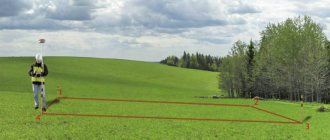
The public cadastral map is an official source. It contains information about the location of all real estate objects according to Rosreestr (plots of land, buildings, residential and non-residential premises). Incorrect display of the boundaries of a land plot often becomes a problem for owners when completing various transactions. The essence of the problem is that the site is located and registered in cadastral documents in one place, but the boundaries are displayed incorrectly on the cadastral map. If you compare the actual boundaries of agricultural land or summer cottages with their display on the map, you can often notice the overlap of one plot of land on another.
Why does the error occur?
The causes of errors in the cadastral map are most often three factors:
- Errors of a specialist, a cadastral engineer, who entered the coordinates of the site into the plan. In this situation, errors are initially contained in the registration data entered into the Unified State Register of Real Estate.
- Error, typo of the technical employee who entered data into the cadastral map program. In this case, the coordinates indicated in the documents are correct; erroneous boundaries are displayed only on the map.
- Errors in satellite video recording are not an error, since in the original version the information about the boundaries was entered correctly.
The procedure for correcting errors in the location of boundaries on a public cadastral map depends on the specific situation. In some cases, it is enough to simply identify an error, draw up the necessary documents and, based on them, make correct changes to the USRN database and the map. In other situations, the rights of the owner or controversial issues of the owners of neighboring plots will have to be resolved in court. Changes are made accordingly by Rosreestr and the map based on a court decision. Next, we will consider several types of errors and options for correcting them.
How should change happen?
First you need to document your changes and enter them into the registry. This procedure is more complicated than when registering with the state, so you may need the help of specialists here. After this, you need to contact the cadastral chamber and get an extract.
Pay attention to the information that will be described in it, because it no longer has to correspond to reality.
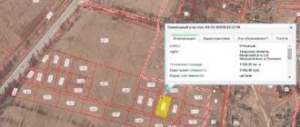
Error - distortion of the boundaries of a particular area
The owner of the land plot saw on the cadastral map that the boundaries of his territory partially overlap with neighboring land ownership. On the map, this distortion looked as if the area was slightly turned along its axis counterclockwise.
When clarifying the details and discussing with the owner of the neighboring plot, it turned out that there were no mutual claims regarding the actual boundaries. The distortion of the boundaries of the site occurred due to an error by the cadastral engineer, who incorrectly reflected the turning points on the terrain. If the plot is rotated clockwise, it will fall exactly within its boundaries.
This kind of error can be corrected as follows:
- carry out a new survey of the site;
- send the boundary plan with the amendments to Rosreestr;
- wait for the data changes to be made within 5 working days.
Who can do the procedure?
Often, it is the owner of the property (land, apartment or other premises) who must perform the entire range of actions.
It is possible for the procedure to be carried out by a third party under a power of attorney, which will be drawn up in his name.
But at the same time, there is an option when any citizens will be able to obtain some information, namely on the following issues:
- Categories of state land;
- Location of the property that is registered with the State Property Committee.
And state companies will be able to request information about the cadastral value of land plots and their plans.
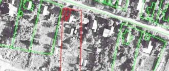
Error - distortion of the boundaries of two adjacent areas
The owner of one of the plots (shown in black as number 2 in the figure) found out that on the map his neighbor’s plot extends significantly into his territory (shown in red dotted line in the figure). As you can see in the diagram, the problem area extends into the territory of three landholdings, it turns out that there are 4 parties affected in this situation, including the owner of the problem area.
The reason for such distortion of the map may be errors of an engineer, technical worker, or a malfunction of the software. All 4 landowners need to act in such a situation.
The error must also be corrected together:
- with the consent and at the request of all owners, a new land survey is carried out by one cadastral engineer, making the binding of the boundaries;
- send the corrected data in the form of a new boundary plan to Rosreestr along with applications for changes from all owners;
- After 5 days the errors will be corrected.
In the next review we will consider the same situation, but with the refusal of the owner of the problem area.
Where to go and what to do?
If you are the owner, you can choose between the cadastral chamber and the MFC branch, which will provide you with all this information. You don't have to come in person to do this. You can use the official government website or send a request by mail. But it’s best to come in person, because you won’t have to spend money on letters and notarization of copies of documents. In addition, if difficulties arise, you can consult with a government agency employee and get answers to all your questions.
Error - violation of the boundaries of several plots when one owner refuses
If we present the previous mistake, but with the condition that the owner of the problematic 8th plot refuses to make adjustments to the general plan and Rosreestr. The refusal manifests itself in the form of a refusal to sign the act, which is drawn up by the cadastral engineer. It is the act that serves as the reason for carrying out a new survey and adjusting the data.
The problem is that if one of the participants refuses, Rosreestr will not give consent to make changes. It will not be possible to solve this problem out of court. What should be done:
- the owners of the plots file an application with the court with a claim to cancel information about the boundaries of the plot, which on the map overlaps with all the others;
- in addition to all participants in the claim, you can involve an official representative of Rosreestr, who will confirm the fact of the error;
- Supporting documents should be attached to the claim - extracts from the Unified State Register for all plots, a copy of the boundary plan.
Changes to Rosreestr in this case are made by court decision and without the consent of the refused owner.
Errors on the public cadastral map can cause a conflict between the owners of neighboring plots. In addition, when carrying out communications (electricity, gas, water) to sites, contractors also use map and Rosreestr information, so serious difficulties may arise here too. If you see a discrepancy between the actual boundaries and the cartographic location of the site, it is better to make changes in a timely manner.
Text: Irina Maslyukovskaya
Grounds for changing the cadastre
Changes to the cadastre must be made in the following cases:
in relation to land plots when changing:
- area of the site;
- addresses or descriptions of land location;
- cadastral value;
- the appearance or disappearance of forest, water and other natural objects located on the site;
- category of land or type of permitted use;
- information about restrictions on the owner's rights.
with regards to buildings, premises, structures, when the following changes:
- main technical characteristics (area, height, number of floors, material of external walls, etc.);
- addresses or non-address descriptions of the location of the property;
- the size of the cadastral value;
- type of purpose of real estate;
- Object name;
- degree of readiness of the work in progress.
The procedure for making changes to the cadastre at the place of application and the time of the procedure is similar to the procedure for registering real estate objects on the state cadastre, but there are still differences.
The procedure for initial registration and amendments to the State Tax Code
Did you know that...
multifunctional] do not always work according to the “single window” principle[/anchor]. The MFC tries to act as a full-fledged intermediary between citizens and some institutions. Their employees receive documents from applicants against signature and transfer them to the Rosreestr authorities. You can appear in person, send documents by mail or electronically through the website of the relevant institutions.
The owner or a person authorized by him contacts the Rosreestr authorities, the MFC or a cadastral engineer. Appeals to the State Committee for Taxation regarding any changes must be documented only. All cases are individual, so there is no standard algorithm of actions at the first stage. To obtain information about what documents are needed, it is better to first obtain information from the cadastral engineers of the State Property Committee Nedkadastr. For example, if the owner decides to change the purpose of the land plot, in order to record this in the cadastre, the district administration (at the location of the property) needs to obtain a document regulating such actions. The next step will be to obtain an extract from the State Property Committee in order to make sure that the current economic and legal state of the site does not correspond to the data about it contained in the database.
First option:
contact cadastral engineers, you can contact ours, or any others.
The engineer prepares a package of documents for you and is guaranteed to make changes to the Cadastre
. A person does not waste time and gets the opportunity to directly communicate with a specialist.
Second option:
Sending documents by any method requires notarization, and if documents are sent via the Internet, then a sample electronic signature is required. A person gets the opportunity to directly communicate with a specialist accepting documents. If any errors were made during registration, they can be corrected and the specialist must tell you how to do this. The best option for the owner is to schedule a consultation with a specialist in advance. The file must contain three types of documents: those that certify the identity of the owner or authorized person, cadastral (technical or boundary plan), decisions, orders, agreements of local authorities. But for each specific situation, their final list may be different.
The first in the package of documents is a Statement of the established form. There is no need to prepare it in advance (if a person delivers the documents themselves). Upon submission, he will be provided with a form and a cadastre specialist will help him write the application correctly. If documents are sent in any other way, a sample can be taken in the appropriate section on the Rosreestr website. It is enough to write the application in a single copy and be sure to sign it. It is advisable to indicate your contact information so that if any discrepancies are detected, the cadastral specialist can directly contact the applicant to clarify the details. The original passport of a citizen of the Russian Federation, and for the authorized person also a power of attorney, which must be certified by a notary, is presented to the Cadastre representative when submitting documents and nothing more. Only copies of these documents are filed in the file.
The main thing in the case is the document on ownership of the object. But there are often cases when for one reason or another it is missing, lost or outdated. Don't despair. In this case, documents are provided on the basis of which it is possible to draw a conclusion about the reasons and conditions on the basis of which the property arose. This could be a purchase and sale agreement, a registration certificate, or a certificate of commissioning. Copies are also filed in the file, but the original document is required to be presented. Otherwise, the application will be refused.
The following important document confirms the changes. Situations may vary. Therefore, for each specific case, an appropriate document will be required. The most common boundary plans, acts or orders on the transfer of land or changing the purpose of a building, technical plan, confirmation of a new address. The objects for registering changes are land plots and capital construction projects. In the first case, making changes is accompanied by drawing up a new boundary plan. For buildings and structures it will be necessary to prepare a technical plan. But there are other types of changes that do not require the receipt of these documents.
If the purpose of the building changes, the applicant must provide a decision on this from the relevant state or local authority to confirm the legality of such an action. The situation is similar with the transfer of land. The owner must present the decision of the state or local authorities authorized to take such actions. If the boundaries of the site, its area and configuration have changed, the owner, in order to register the changes, must provide the Cadastre with a boundary plan prepared taking into account the changes. If the building parameters have been updated: number of storeys, external wall finishing material, configuration and area of construction, a new technical plan is provided, although the old one is left in the file along with it. If the address has changed, a resolution from the relevant municipal authority is provided. Similar documents are needed if the type of use of the land plot has changed. In this case, they may also require a certificate from the architecture department.
To confirm the receipt of documents by the state cadastre body, its employee issues a receipt to the owner or authorized person listing those received, the date of their receipt, as well as the approximate date when the owner can appear at the cadastre to receive an updated extract.
The procedure does not require payment of a state fee; according to the law, changes are made free of charge. The small amount you are asked to pay is a fee for the document forms. On the date specified in the receipt, the owner or authorized person, with identification documents, appears at the territorial office of the state cadastre or MFC. And they receive a statement containing updated information about the object. After receiving it, the procedure is considered completed.
What information is entered into the State Property Committee for apartments, houses and buildings?
With regard to structures, buildings and premises, the cadastre is addressed if the technical characteristics of the object have changed: its number of storeys, configuration, area, or if a material different from the fixed one is used for the construction of external walls. It is also necessary to display the change in address (or primary assignment), location, name, purpose of the building, and the degree of its readiness. More often, changes occur after the completion of construction work, because a number of transactions, for example, agreements of assignment or equity participation, are recorded in Rosreestr even before the appearance of real estate as such. After completion of the work, adjustments must be made. This is a mandatory procedure.
What happens if you don’t register an object with Rosreestr?
Cadastral registration has actually become a mandatory procedure since 2021. The legislation does not provide for strict deadlines for completing this procedure or fines for lack of information in the Unified State Register of Real Estate. However, without registering with Rosreestr, the owner will not be able to dispose of the property, sell, give or lease it.
If the object was erected or formed before 2013 and is not listed in the Unified State Register of Real Estate, documents for real estate accounting may be submitted when registering the transaction. This is convenient because you do not need to undergo separate procedures.
Why can they suspend or refuse the procedure for registering a land plot?
When applying for cadastral registration services, you may be faced with decisions of the registration authority to suspend or refuse.
Clause 1 of Art. 26 of Federal Law No. 218-FZ of July 13, 2015 establishes an exhaustive list of grounds on which suspension of the provision of public services is possible. Among them, the most common are:
- application from a person who does not have the authority to perform accounting;
- lack of a complete set of documents;
- the materials submitted for registration have inaccurate or controversial data;
- the applicant does not have rights to the property.
If the registration authority identifies one of the grounds for suspension, an appropriate decision is made and communicated to the applicant. The maximum period for eliminating deficiencies is three months.
The reason for refusal can only be failure to comply with requirements, which was the basis for suspension of cadastral registration. This exceptional position is enshrined in Art. 27 of the Federal Law of July 13, 2015 No. 218-FZ.
Dacha amnesty extended: what to do before 2021
The concept of dacha amnesty refers to a simplified procedure for completing the procedures necessary for cadastral registration and registration of rights to land plots, residential buildings or outbuildings.
The dacha amnesty is included in the concept of cadastral registration of land plots; 2021 brought changes due to the entry into force of Federal Law dated August 2, 2019 No. 267-FZ. In accordance with it, the period of validity of the simplified procedure has been extended until 03/01/2021. Such a restrictive period affects only individual housing construction projects, therefore there are no time restrictions for land plots.
The procedure for registering through a dacha amnesty is as follows:
- Contact the MFC with an application for state registration of the right to the object. The application is completed by an employee of the multifunctional center.
- Provide documents that could confirm your rights: an act from a government agency or an extract from the household ledger.
- Registration of rights and receipt of an extract from the Unified State Register of Real Estate confirming the fact of registration actions.
The above procedure applies to land plots, the rights to which arose before October 25, 2001. Registration occurs regardless of the type of right on the basis of which the property was acquired (property, inheritance, permanent use).
What's worth remembering?
It is important that processes such as deregistration and re-registration differ from simply correcting errors.
The first case occurs if you made global changes and used several real estate objects at once. If you simply increased the size of your land plot, then it will be more likely that changes must be made to the cadastre. If you made an extension and put the main operational services into operation, then we are talking about deregistering one object and setting up a new one, changing the plan. Error correction is of a different nature. This happens at the initiative of representatives of government agencies or at your request, provided that you have found inconsistencies in the plan, passport or other document.
Treat the procedure very carefully, because we are talking about important documents that will later be used to complete real estate transactions. Therefore, all information in them should be as fresh and accurate as possible. Even the ownership of a particular property will depend on this.
Recording changes is also important because failure to comply with this condition may result in administrative or criminal liability.