A plot of land is the surface of the earth, which, according to objective criteria, can be attributed to an individually defined thing. Each allotment has its own limits, which are established both in fact and in documents. But violation of land boundaries is a fairly common problem among owners.
Cameraman Alisa Lawyer
Dear readers! Our articles discuss typical situations for resolving legal issues, but each problem is unique. Therefore, if you need a FREE consultation with a lawyer, call ext 946 (Moscow and Moscow region) ext 651 (St. Petersburg and Leningrad region)
When citizens cannot agree among themselves peacefully and an article of the law is an empty phrase for them, there is only one way out - to go to court, and in this case the help of an experienced specialist is needed who will help not only draw up a statement, but also organize the necessary examinations and provide current sample documents on this issue and will tell you what to do next.
Here you can >> To resolve your issue, you can ask a lawyer.
Examples of boundary violations from life
Disputes about the boundaries of land plots are currently one of the most common categories in district courts. Owners of plots located in the neighborhood often cannot agree on the location of the fence that divides their property, or it is a question of violating the boundaries of part of the plot when installing a fence or building a balcony.
There are several reasons for this:
- mistakes made by the cadastral engineer when carrying out land surveying work;
- unauthorized seizure of part of the territory by a neighbor;
- contradictions in old documentation or inclusion of irrelevant information.
Pre-trial settlement
Pre-trial settlement is only possible if the owners of two adjacent plots are ready to cooperate with each other .
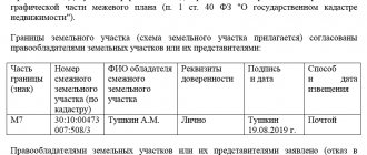
The first thing they need to do is order clarification of the boundaries of land plots.
According to paragraph 10 of Article 22 of Federal Law No. 218, clarification of boundaries occurs in compliance with the following features :
- The boundaries of the allotment are determined from the information specified in the documents of the owners, defining their right to own the land;
- If there is no such document or it does not contain the necessary information, the boundaries are specified in accordance with the document defining the boundaries of the site when it was formed (when the site was first registered);
- If this document is not available, the boundaries are determined in accordance with the established urban planning plan of the territory;
- In the absence of all the specified documents, the boundaries of the plots are determined based on the actual boundaries that have been observed between the plots over the past 15 years.
If both owners of adjacent land plots agree with the results of repeated land surveying (clarification of boundaries), they need to make appropriate changes to the Unified State Register of Real Estate .
To do this, you must fill out an application in the form established by Order of the Ministry of Economic Development No. 722 of 2013.
You will also need copies and originals of a number of documents.
The application must be accompanied by:
- A copy of a civil passport;
- Title documents for land;
- Cadastral extract, which displays incorrect information about the site;
- Corrected boundary plan.
According to paragraph 3 of Article 61 of Federal Law No. 218, an error in the Unified State Register must be corrected within 5 days from the date of receipt of the relevant documents by Rosreestr.
If the EGRN contains correct data on land surveying, there is no need to send a separate application there; to put the boundaries in order, the neighbors only need to agree on moving the fence .
Where to contact?
Before taking specific actions, it is necessary to determine what caused the violation of the boundaries of the land plot. If we are talking about an error in the USRN information about a land plot, then the procedure is as follows:
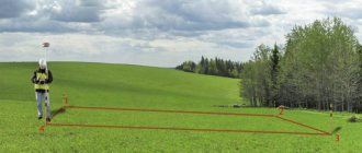
- Contacting the cadastral engineer to obtain an act of approval of the boundaries of the land plot, which is drawn up on the reverse side of the graphic part of the boundary plan. To do this, it is necessary to notify all owners of adjacent plots and obtain their consent to establish boundaries. All claims and comments of the owners must be included in the deed.
- Initiation of re-negotiation of allotment boundaries. It is quite possible that during land surveying the boundaries of the land plot according to the boundary plan were violated. To correct the error, you need to contact the territorial division of Rosreestrai to write a statement about violation of the boundaries of a plot of land.
- If it is not possible to resolve a land dispute with neighbors voluntarily, the interested party must go to court with a statement that the neighbor has violated the boundaries of your property. Moreover, such actions are subject to liability in the form of a fine under Art. 7.1 of the Code of Administrative Offenses of the Russian Federation - for illegal occupation of someone else’s land or part of it.
Kinds
In fact, there are only 2 types of violations :
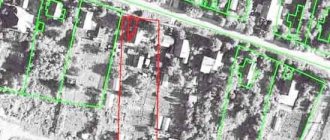
- Overlapping or crossing real boundaries on the ground;
- Overlapping borders in documents (registry error).
There are 4 reasons why the real boundaries of land plots may overlap on the ground:
- Error in information stored in the Unified State Register of Real Estate;
- Error of the responsible person when establishing boundaries;
- Unauthorized seizure of territory;
- Changes in the coordinates of the turning points of the site due to changes in the landscape.
What to do if a neighbor violates the boundaries of the land plot?
Occupying someone else's land is an illegal procedure. But the parties do not always know about the illegality of their actions. A situation may arise that a tree has always grown in adjacent areas, and the neighbor thought that it was from this tree that his fence would begin.
But in practice it turned out that he ended up on someone else’s site. In this case, the parties must understand the current situation and resolve the border dispute. This can be done either through negotiations or, if consensus is not reached, by going to court.
Resolving the dispute peacefully
If disagreements arise between the owners of adjacent plots regarding the establishment of the real boundaries of the plot, first it is necessary to negotiate and find out the reason for the change in the size of the plot. This could be inaccuracies in documents, incorrect installation of fencing on the site, etc.
After this, the interested party can contact the registration authority and write a statement that he asks to determine the real boundaries of his site according to the law and attach all the necessary documents to it. In this case, a second agreement will be held and the parties will be able to express their opinions.
But if, for example, a house is built in violation of boundaries or there are other structures that stand on someone else’s property, and the neighbor does not want to demolish or move them, then the case should be taken to court.
Going to court
If the issue of violation of the boundaries of the plot cannot be resolved peacefully, the party whose rights have been violated has the right to file a claim to establish the location of the boundaries of the plot with the district court at the location of the plot.
The owner of the adjacent plot will act as a defendant in the case; a cadastral engineer and a representative of the rights registration authority should be involved as third parties.
The second important point is the formulation of claims. They may be as follows:
- recognition of the established border between plots as a technical or registry error;
- establishment of a new adjacent border.
We enclose a package of documents with the claim to the court:
- copies of the claim by the number of parties involved in the case (defendants and third parties);
- receipt of payment of state duty;
- title documents for the site;
- a copy of the boundary plan, if available;
- information from the Unified State Register of Real Estate about the neighboring plot;
- other documents that support the arguments set out in the claim.
After the court decision comes into force, the applicant must contact the registration authority with an application for registration of the plot or with an application for registration in connection with updating the boundaries of the plot.
An example from judicial practice
In 2021, the Krasnoozersky District Court heard a case about establishing the boundaries of the land plot and demolishing buildings.
A dispute arose between the owners of adjacent plots. Plaintiff A. carried out land surveying, but defendant B. did not agree with the results and refused to move the fence and demolish the outbuildings. buildings, since its documents indicate completely different boundaries. The parties were unable to reach an agreement on their own.
In refutation of the plaintiff's claims, the defendant stated that the plaintiff seized part of her territory and erected a hothouse and a bathhouse, attaching it to the wall of her building. In winter, snow from the buildings melted into the defendant’s yard, making it impossible to organize walks for my daughter with limited mobility (disabled). A counterclaim was also filed.
The court refused to satisfy the claim, but decided to satisfy B.’s demands and ordered A. to demolish the buildings within a month, and also to collect 5,160 rubles from A. towards reimbursement of legal expenses.
The reason for this decision was that B. acquired ownership of the plot much earlier than A. It was also established that B. carried out the land surveying procedure in accordance with the requirements of the law, and the coordinates of the plot were determined.
How can a lawyer help?
Let's look at 4 situations and decide what kind of legal assistance you may need.
- Dispute about imposing boundaries. It arises if one plot was previously registered, for example, under the “dacha amnesty”, and land surveying was carried out on the other. In this case, the lawyer must find documentary evidence of the boundaries of the plot or confirm that the fence that has been on the plot for 15 years is the very line dividing the property. It would be useful to conduct peaceful negotiations and clarify the circumstances of establishing the boundaries of the site. For example, earlier in this place there was a tree, a bridge, a pillar, according to which the edge of the earth was determined.
- Dispute about squatting. There is an unauthorized occupation of the land plot by neighbors who moved the border of their land and “went in” to the neighbor, thereby reducing the area of his allotment. In this case, the lawyer must prove that:
- that the seizure was indeed unauthorized;
- determine the old boundaries of the allotment (either by documents or by identification marks);
- find witnesses or conduct a notary inspection of the site to establish boundaries;
- identify persons who are responsible for trespassing.
- Dispute with the registration authority about entering information about land into the state real estate cadastre. In this matter, the main thing is to be prompt, since you can challenge the cadastral engineer’s conclusion within 3 months from the date he signed the document. You need to prove 2 things:
- the boundaries from the boundary plan correspond to the title documents;
- denial of cadastral registration is illegal.
- Conducting land management examination. This procedure is the main one when establishing the boundaries of land plots. A lawyer will help you correctly formulate the questions posed to the expert, on which the decision of the court case will depend.
The main thing a lawyer can help with is to draw up a sample statement of claim for trespass.
Standards for placing buildings on the site
Violation of the boundaries of use of adjacent plots always leads to a dispute between neighbors. It is advisable to resolve such a conflict situation peacefully. For example, concluding a settlement agreement that needs to be certified by a notary. However, if the dispute could not be resolved, then only the court can decide who is right and who is wrong.
Violation of the boundary of an adjacent plot during the construction of buildings means that the developer does not comply with the norms of setback from the neighboring plot. This not only creates inconvenience for citizens who live in the neighborhood, but can also lead to emergencies.
They consist of flooding the neighboring area during heavy rain - water from the roof will flow to the neighbor. Or, in the event of a fire, firefighting equipment will not be able to reach the required building.
Naturally, every developer wants to place buildings conveniently for themselves. However, the interests of neighbors should also be respected.
Therefore, the owner of the site, before proceeding with the construction of a residential building or other building, must familiarize himself with the requirements of urban planning regulations. They contain information about all permissible distances from the building site to the boundary of the site.
Important! Thus, the minimum distance that must be maintained is:
- 5 meters between the building and the pedestrian line or roadway;
- 3 meters from an individual residential building to the entrance area to the land plot;
- 3 meters between a residential building and a neighboring plot;
- 6 meters from the nearest window opening to the building on the adjacent plot;
- at least 1 meter from the bathhouse, garage, shed to the line of the neighboring land plot;
- 4 meters from places where pets are kept to the fence of the neighboring property;
- the same distance should be from the trunk of a perennial tree to the neighboring area;
- for low-growing trees, the distance is halved.
Attention! Our qualified lawyers will assist you free of charge and around the clock on any issues. Find out more here.
How to resist the neighbors who started this
Whatever the emotions, any actions in such cases must be consistent with the Law.
Namely, by acting within the limits of what is permitted, you can achieve the final result you require in the confrontation with your boorish neighbors. Many people associate the word “Law” with the word “bureaucracy,” but this is not so. Judicial practice in cases of flooding of land is quite rich; a clear algorithm for making decisions in favor of the injured party has already been developed. Before writing a statement of claim, you need to obtain two documents - an act on the fact of flooding of the site and a report on an independent assessment of the damage. The certificate of flooding of a land plot is authorized to be issued by: the village administration, the board of the dacha cooperative, the district commissioner and other government representatives in the locality. That is, this document is needed so that the court can see that flooding took place. This act is similar to a certificate of road accident, which is drawn up by the State Traffic Safety Inspectorate in the event of an accident, or a report of flooding of an apartment, which is issued by the DEZ in case of flooding of the premises.
An independent assessment of the damage caused to the land plot is needed to determine the cost of restoring the property to its original condition. As in the two above cases, an expert opinion on damage to a land plot is required to justify the cost of the claim to the court. A document expressing exactly the monetary amount of damage is prepared by an independent appraiser, who should be called to measure and photograph the extent of flooding of the summer cottage. The same damage assessment report is made when a neighbor has unauthorizedly moved a fence, dumped construction debris, broken a gate or broken trees.
How much does it cost to assess damage to a land plot?
The cost of the appraiser’s services depends on the specifics of the damage caused and is individual in nature. We cannot attach a table of prices to this article, as is the case with assessing damage after an apartment was flooded or as with assessing land as a single piece of suburban real estate. As a rule, the cost of damage assessment services on a site varies from 4,000 to 10,000 rubles. The exact cost of the services of an independent damage assessor depends on the specifics of the damage.
Damage can be caused not only to structures, but also specifically to the personal plot where these objects are located. Often there is a disrespectful attitude from neighbors in the area. Due to the irresponsible actions of neighbors or construction organizations, the land plot turns into a swamp or landfill, and a residential building, outbuildings, trees, shrubs, and planted plants are damaged.
The nuances of drawing up a statement of claim
When drawing up a statement of claim yourself, you should keep in mind the following nuances:
- the document must contain detailed information about the parties to the conflict. That is, personal data is indicated in full, and not in abbreviated form;
- before going to court, it is necessary to file complaints with local authorities and receive official responses;
- all written evidence is attached to the statement of claim in copies, however, you must have the original documents with you, since the court will definitely require them to be presented;
If experts confirm that due to the proximity of a neighboring house, cracks have appeared on yours, fungus and mold have formed, then you can demand the demolition of the problematic house.