If the required data about the requested area cannot be found out using a cadastral map, then you need to send a written request to Rosreestr and find out the reason for the situation.
For a number of reasons, the allotment may not be taken into account and, accordingly, not entered into the general file database.
After discovery, many people ask the question: “Why is my plot not on the cadastral map and what should I do?”
We will talk about this in the article.
What is a public card for?
A map of land plots is an electronic file cabinet where information about each object registered for a specific enterprise or citizen is stored. Anyone can gain access to primary information. The database includes all registered land plots, data on which is in the real estate cadastre of the Russian Federation.
To work with the map, the service provides simple functionality that allows you to find cadastral division units, objects of interest and obtain information from the archives of the State Property Committee.
Using an electronic card you can get:
- detailed information on a specific real estate property;
- cadastral division, find out the boundaries with adjacent territories;
- whether the site belongs to zones with special conditions of use.
It is extremely important to know in advance if a property is allowed to be used with restrictions.
also worth finding out information about neighboring adjacent territories so that there are no restrictions on them. Otherwise, it will be impossible to engage in any type of activity on the land due to its proximity to special objects, which makes the purchase impractical.
If the plot number is known, then its location and boundaries with neighboring lands can be established.
Using the service is similar to searching in Google Maps.
But in addition to the address, numbers assigned to objects are used.
The public cadastral map allows you to find out only primary information about the site .
Information is provided about whether a specific plot exists, in what area it is located and whether it has official registration.
The cadastral number assigned to each object is a number consisting of several parts. By number you can determine whether you belong to a particular region.
If the address of a building or land plot is known, then it is easy to determine its cadastral number or vice versa:
- The first digits indicate the county
- second - district
- 3rd part – quarter
- 4th – section
After the object is found and appears on the screen, you can get more detailed information by clicking on it.
The map is presented to scale with easy-to-use visualization tools for viewing. Using an electronic card index, you can view satellite images of the area, digital topographic maps and orthophoto coverages .
If you need information about the status of an object, you can find out this information. An object can be accounted for, previously accounted for, or temporary.
How errors occur
The cadastral map reflects the errors of participants in cadastral procedures. This happens when a cadastral engineer, land owner or Rosreestr employee makes an error in the coordinates. Rosreestr distinguishes two types of such errors.
Registry error
— the cadastral engineer entered incorrect coordinates into the original boundary plan and this erroneous information is registered in the Unified State Register of Real Estate.
In addition, Rosreestr employees may make technical errors
and typos. Then the correct coordinates from the boundary plan are distorted, and despite the reliability of the original documents, shifts in the corner points of the site appear on the cadastral map.
It happens that owners take mistakes
errors in satellite photography. And some are inclined to attribute their false ideas about boundaries to a mistake. It is important that in such situations, the USRN data corresponds to the legal state of affairs.
Correcting an error means making correct changes to the Unified State Register of Real Estate. There are two ways to make such changes: out of court and based on a court decision. The first method is distinguished by the absence of claims from third parties - owners of adjacent plots. If a conflict arises with neighbors, changes to the Unified State Register can be made by court decision. Let's look at standard situations.
Error 1. Distorting the boundaries of one area
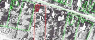
The owner of plot 54:07:054701:105 found out that on the Rosreestr map the boundaries of his plot overlapped with his neighbors’ plot: 348. It looks as if the problem area was turned counterclockwise.
Together, the neighbors found out that they had no mutual claims regarding the actual borders. Here we can deal with a registration error by an engineer who incorrectly determined the coordinates of turning points on the ground or made a mistake when drawing up a boundary plan. If the engineer did everything correctly, then a technical failure occurred on the side of Rosreestr.
How to fix:
Let's mentally rotate the problem area clockwise. It will precisely lie on its actual boundaries, maintaining its area and configuration. The boundaries and area of adjacent areas remain unchanged. This means that the owners have no claims against each other. This fact determines the out-of-court procedure for correcting the error.
If the engineer makes a mistake:
We do the surveying again.
To redo the project for free, we recommend contacting the cadastral engineer who made the mistake. The engineer can be brought to disciplinary liability, up to and including expulsion from the membership of the self-regulatory organization of cadastral engineers;
We send it to Rosreestr
updated boundary plan and statement of error correction. Documents are submitted through any MFC, since from January 1, 2021, Rosreestr does not accept citizens;
Rosreestr will correct the error
within 5 working days.
If you made a mistake in Rosreestr:
We submit an application to Rosreestr
through the MFC to correct an error in the USRN records;
Rosreestr will correct the error
within 3 working days.
Error 2. Distorting the boundaries of two or more areas
The owner in the center found out that his plot overlaps with the neighboring ones. The situation is complicated by the fact that the area adjacent to it is also displayed incorrectly on the map.
How to fix:
It's like a domino effect - you'll have to fix sections one by one. We will sequentially go through a chain of corrections to the boundaries of all sections, starting with section No. 2.
We are identifying all the victims
owners and agree on boundaries. The changes will not affect only the owner of plot No. 1;
We do land surveying
all problem areas again. It will be more convenient for everyone if the boundaries are tied at the same time by a single contractor. You can try to eliminate the shortcomings at the expense of the person responsible for the original error;
We send it to Rosreestr
updated boundary plans along with statements about correcting the error. This can also be done by the surveyor;
Rosreestr will correct the error
within 5 working days.
Error 3. Refusal of a neighbor to agree on boundaries
Let's complicate the previous problem. The owner of plot No. 8 does not agree to change the boundaries of his plot. He refused to sign the proposed border agreement act. Perhaps he is satisfied with the erroneous configuration entered into the Unified State Register of Real Estate and insists on its authenticity. Rosreestr will refuse to register changes in the boundaries of all other areas.
How to fix:
will have to go to court. We demand that the information on the boundaries of the property of the dissenting owner be canceled due to a technical or registry error in the Unified State Register of Real Estate. Rosreestr can be involved as a third party. We enclose with the statement of claim: extracts from the Unified State Register of Land Registers for our own and adjacent plots, a copy of the boundary plan, confirmation of payment of the state duty.
After the court decision enters into legal force, we contact Rosreestr through the MFC. Attached are boundary plans and statements to clarify the boundaries of all plots.
Error 4. Shift of satellite photos
A situation often occurs when, when superimposing the coordinates of a cadastral map onto satellite photography, all areas
the blocks are equally shifted relative to their actual boundaries. It looks like this:
How to fix:
the shift is associated with errors in satellite photography, which Rosreestr has nothing to do with. Therefore, everything is in order with the site, the Unified State Register contains the correct data, which means there is no need to make changes. If you need an accurate image, simply move the card backing.
On the right, under the selection of satellite layers, there is a “Customize map” link. Click it and use the arrows to adjust the image until the borders align correctly:
Let us repeat that this is done only for your convenience and does not in any way affect the data in the Unified State Register of Real Estate.
Mistake 5. False boundaries
The owner of plot No. 2 is sure that his plot is displayed incorrectly on the cadastral map. It claims a large area. Perhaps he even surrounded the area with a fence, and none of the neighbors voiced complaints. There is no technical or registry error in the USRN.
How to fix:
The public map displays everything correctly. We are faced with land squatting. It happens that, using the adjacent territory for a long time, the owners automatically attribute to themselves the “extra” acres. This is illegal and is subject to administrative prosecution under Art. 7.1 Code of Administrative Offenses of the Russian Federation. However, if the owner of plot No. 2 is confident that he is right, he will have to substantiate his claims in court. In essence, we are talking about legalizing squatting and acquiring another piece of real estate.
Set the current owner
disputed area. Often this is a rural settlement, an urban district. As a starting point we use Art. 11.7 of the Land Code of the Russian Federation “Redistribution of land plots”;
Be prepared for land surveying
and registration of the site for cadastral registration;
Document your reasons
your claims and contact the current owner pre-trial. Be prepared to justify your position in court;
If there is no confirmation
possession use Art. 234 of the Civil Code of the Russian Federation on acquisitive prescription. Also consider purchasing a plot at auction.
Cadastral value
Using a public map, you can find out the price of an object, but not the market price, but the cadastral price , formed by Rosreestr taking into account market demand for certain real estate.
How they differ from each other can be found in the feature article.
Cadastral valuation is carried out by engineers, taking into account the location of the object, its condition and other significant factors.
Let's sum it up
The question of why my house is not on the cadastral map has several answers. The reasons are usually related to the lack of a technical plan or unreliable credentials. Inaccuracies in cadastral registration can be corrected by registering an up-to-date technical plan and eliminating technical errors.
To draw up or correct a technical plan, it is imperative to involve only qualified specialists.
In case of discrepancies between the data of Rosreestr and the public cadastral map, priority is given to the information specified in the extract from the Unified State Register of Real Estate.
Sources
- https://www.comfortclub.ru/publ/raznoe/nedvizhimost/net-doma-na-kadastrovoj-karte-pochemu-i-chto-delat.html
- https://egrp365.ru/info/pochemu-uchastka-net-na-kadastrovoj-karte.html
- https://pkk365.ru/spravochnaja-informacija/esli-na-publichnoj-kadastrovoj-karte-net-uchastka-chto-jeto-znachit/
- https://egrnreestr.ru/articles/pochemu-moego-doma-net-na-kadastrovoy-karte
- https://stroim-domik.org/podgotovka/zemelnyj-uchastok/kadastr/karta/prichiny-otsutstviya
- https://egrp365.ru/info/chto-delat-esli-zemelnyj-uchastok-nepravilno-otobrazhyon-na-kadastrovoj-karte.html
Why might the allotment not be in the database?
For some reasons, information about the site may not be in the cadastral database.
To find out why this happened, you need to make a request to Rosreestr in writing.
There may be a missing registration , which can be easily fixed.
Another reason for not entering a site may be land surveying carried out before 2001 .
To eliminate the cause, you need to contact the state registration service and schedule a new survey.
The same procedure is required if there is no data on the boundaries of the site.
It is worth noting that real estate transactions can be carried out even if the site is not on the public map. Any party can appoint land surveying.
What to do if registration is missing?
If information about the site is not on the electronic cadastral map due to the fact that the object is not registered in a certain legal manner, then to correct the situation the following must be done:
- carry out land surveying;
- collect documents (the list depends on the method of obtaining the land: inheritance, donation, purchase, sale, and so on);
- submit to Rosreestr documents, land surveying, the applicant’s passport and a receipt for payment of the fee
After reviewing the request, the owner of the site will receive a document confirming ownership rights . Rosreestr employees will then mark the plot of land on the public cadastral map.
If surveying was carried out before 2001
There are situations when a plot is assigned a cadastral number, it is the property of a citizen (there are title documents to confirm this), but there is no information about it on the electronic map.
The reason for this may be land surveying if it was carried out before 2001, that is , before Law No. 28-FZ of 01/02/2000 came into force.
But at the same time, No. 221-FZ of July 24, 2007 contains a provision according to which plots that were properly registered before the act came into force are previously taken into account.
Information about these lands will be entered into the cadastre after the owner applies to Rosreestr and provides title documents.
The citizen may be required to re-define the boundaries of the site, that is, carry out land surveying again.
If there is no distinction
When information about an allotment is not entered due to a lack of information about its boundaries, then the citizen must carry out a land surveying procedure. To do this you need:
- Collect documents confirming ownership.
- Conclude an agreement with a land management organization . It is recommended to agree in advance on the terms of surveying, the cost of work and the payment procedure.
to delimit a site on your own without the appropriate license .
After the work is completed, the owner of the site will receive two copies of the survey file, one of which must be transferred to the cadastral chamber.
The main thing about areas without borders
If the boundaries of your site are not visible on the map, then most likely land surveying has not been carried out in accordance with current legislation. This does not deprive you of ownership of it. The law does not oblige the copyright holder to carry out land surveying. But selling such a plot will be more difficult. Rosreestr has the right to suspend registration of the transfer of rights and then the transaction will not take place.
It is important that unregistered boundaries reduce the market value of the property and provoke conflicts with neighbors. It is impossible to carry out legal construction on such a site. Therefore, we recommend conducting boundary surveys before the purchase and sale transaction, as well as when planning construction.
If your site is marked on the map, but the boundaries are incorrect, this is a different situation. It needs to be fixed urgently. We wrote about the reasons and methods in a separate article.
Is it possible to get a USRN extract for free?
Since today there is a law on “dacha amnesty” in Russia, many summer residents and land owners formalize their rights in a simplified manner, and in this case, land surveying according to the law is not required. Hence such “general” data - there is a cadastral number, but, alas, there are no borders.
If not, then we are busy with registration of property rights. We check that the house is displayed on the public cadastral map YES/NO.
Good evening. Please tell me. We want to buy a plot of land with a dilapidated house. We will dismantle the house and build a new one in another place. According to the State Register, there is no house on the site, there are no documents for the house. But, as I understand it, according to the BTI the house exists (there is a cadastral number for the house).