Any land plot can be considered a private property only after its official registration with the Office of the Federal Registration Service. To carry out this procedure, you first need to determine the boundaries of this object.
The need to determine the boundaries of plots arises when any misunderstandings arise between the owners of neighboring lands.
The procedure is also important in the absence of a cadastral plan for the site, its passport or an agreement signed by all owners.
When the owners of one of the neighboring plots want to build a fence, they will need to define or clarify the boundaries. The entire process of determining boundaries consists of several stages.
Dear readers! Our articles talk about typical ways to resolve legal issues, but each case is unique. If you want to find out how to solve your specific problem, please contact the online consultant form on the right. It's fast and free! Or call us at :
+7 Moscow, Moscow region
+7 St. Petersburg, Leningrad region
8 Federal number (free call for all regions of Russia)!
How to determine the boundaries of a land plot by cadastral number
If you have information about the cadastral number of the plot, then it is quite possible to independently find data on the land demarcation lines. To do this, you can use two methods. First, try to get data from Rosreestr using the Internet.
What you need to do for this:
- Go to the Rosreestr website at https://rosreestr.ru. If you do not know the site address, it is quite possible to find the necessary page in a search engine. Enter the required query, for example “cadastral plan of the land plot”;
- If everything worked out for you and you are on the right page, below you can see the highlighted inscription “Public Map”. Continue your search by activating this inscription;
- When the next window opens, click the magnifying glass in the search and write down the cadastral number of the object you need in the empty line;
- After a while, you will see a diagram of the site with exact survey lines;
- To hide the search menu, you need to click on the magnifying glass again.
This card has some other functions that allow you to get more accurate information:
- To use these features, you must activate the Control pointer. This will give you the opportunity to familiarize yourself with the images taken by the satellite, change boundaries, remove various inscriptions, etc.;
- To obtain calculations of distances and sizes, you must use the “Measurement” item;
- Also, using the map you have the opportunity to obtain additional information. To do this, you need to click on the letter “i”, the so-called “object at a point”, and then again on the subject of study;
- Help data will be available after clicking the question mark icon.
To obtain information for drawing out the demarcation lines of a land property in situ, you need to correctly formulate the request.
To do this, find in the section. At the next stage, select the section KV.1 - KV.6 and enter all the data mentioned in the remaining fields of the request.
Searching for information on a public cadastral map is the second way to obtain information.
In general, there are two options for a cadastral map:
- By typing the website address https://kadastrmap.ru into a search engine, you will receive the same information that can be found using the first method described above. There is only one small feature: here you can enter the number in a separate search line located at the top;
- By going to the address https://pkk5.rosreestr.ru, you have the opportunity to obtain the necessary data by using the “advanced search”. This version of the map contains control and measurement icons on the outer contours of the map.
What should you do to get the most complete information?
Sometimes the information obtained on the Internet from the above sites is not enough. In this case, you can obtain more accurate data or a legal document by contacting the Rosreestr portal online.
To obtain an extract or cadastral plan of a land plot, you need to take the following steps:
- Use the link https://kadastrmap.ru/zakazat-dokumenty-s-rosreestra;
- Find the document you need on the page;
- Enter the cadastral number in the required fields and write down your personal data on the right side;
- Make payment for services provided;
- At the next stage, you will receive further instructions (they will be sent to your e-mail or phone). Sometimes you will be asked to clarify the reason for the request or the recipient's address.
Clarification of the boundaries of the land plot.
How to resolve land disputes about the boundaries of a land plot, read here.
How to carry out land surveying, read the link:
What should be the size of the plot for building a house?
To estimate what size plot to choose, the classic formula is suitable: the area of the house should be no more than 1/10 of the area of the territory. Thus, if you want to build a compact one-story cottage of 100 m², you need to choose an object with an area of at least 10 acres.
The proportionality of the house and the site is important. On the same 10 acres, you can build a larger cottage, but in this case it will be more difficult to comply with building regulations that relate to the distance of a residential building from neighboring buildings and the entrance. In addition, with full construction there will be no room left for a garden, swimming pool, barbecue area, bathhouse and other attributes of country life.
Examples of competent distribution of space on objects of different sizes:
- 6 acres - a small dacha or a 1-2-story house for permanent residence 7x8 meters, a compact vegetable garden or a comfortable place to relax;
- 7-10 acres - a larger 1- or 2-story cottage with a carport, a bathhouse, a vegetable garden, a small pool or a children's playground;
- 11-20 acres - a residential building, a bathhouse, outbuildings, landscape design elements and a spacious recreation area;
- 20-30 acres - a cottage for a large family and several functional areas.
How to determine the boundaries of a land plot on the ground
The methods of the modern land surveying procedure are so precise that they do not allow for large errors. The procedure is carried out by representatives of the geodetic company. In their work, they use state-of-the-art equipment, GPS, and satellite imagery.
In order for the work to be carried out in accordance with the specified requirements, a special scheme of work for specialists is used when identifying the boundaries of areas.
What are the instructions for land surveying?
This scheme is used by specialists carrying out the relevant work. This official document was approved on April 8, 1996 by the Committee of the Russian Federation, which is in charge of land resources and land management. Subsequently, this instruction was approved by experts of the Ministry of Justice on July 28, 1996, under No. 07-02-516-96. You can download the instructions here.
The scheme of the work performed, enshrined in the instructions:
- what work is being performed;
- basic requests for accuracy;
- in what order the work is performed;
- who controls and accepts the work performed;
- direct preparation of a cadastral report on the allocation of boundaries.
Standards for the production of works are generally accepted. Customers, regardless of the basis on which they own the land, have the opportunity to verify the work. The instructions also indicate the required scale, requirements for the accuracy of measurements, etc.
Specialists performing this work can only act in accordance with the rules set out in this manual.
Otherwise, if any requirements are not met, the results of the work will be considered invalid. Cadastral engineers performing these measurements must have special training.
What to do if you want to survey a plot of land?
To begin with, the customer needs to contact the geodetic company that services the territory where the object under study is located. To carry out this work, surveyors, a cadastral engineer and the land owners themselves must go directly to the site.
To avoid any misunderstandings, the customer must familiarize himself with the documents confirming the right of these specialists to carry out land surveying work.
The service itself can only be ordered directly by the owner of the land or his representative who has a power of attorney for such actions. The document is certified by a notary.
To begin work, you need to write an application and submit it, along with documents confirming land ownership, to the appropriate organization.
What documents are required to begin land surveying work?
To complete an order, you must provide the following documents (originals and copies):
- passport of a Russian citizen. If the customer is an authorized person - a power of attorney;
- papers confirming the fact of land allocation or an agreement to conclude one of the types of transactions with real estate;
- document of ownership or cadastral number of the plot (if such documents exist).
When there are no documents specified in the last paragraph, you need to leave a request to register the land plot accordingly.
Sometimes land has multiple owners. In this case, you need to submit documents of all owners.
In case of separation of one of the owners, he needs the following supporting documents:
- papers on the concluded allocation agreement;
- confirmation by other owners of consent to this procedure.
Drawing up a power of attorney
This document can be drawn up for one of several owners. Thus, the presence of this paper indicates the consent of the remaining owners to carry out land surveying work.
An authorized person may be:
- a citizen authorized by a legal entity;
- a person who is related to the owner;
- real estate agent;
- lawyer and other persons.
There are two ways to draw up a document: directly at a notary’s office or by drawing up a document yourself and having it certified by a notary.
If the customer for the work is a legal entity, its authorized person acts on the basis of a trust document.
Registration of received information
The cadastral engineer is obliged to transfer the results obtained on the basis of the work performed to Rosreestr. The customer receives a corresponding act on the land surveying procedure carried out and a land plot plan in paper form.
The assignment for surveyors is drawn up on the basis of land surveying. This, in turn, is carried out at the request of the owner of the site. This application contains the purpose of the work, as well as an extract from Rosreestr.
Land surveying is carried out in accordance with the instructions mentioned above, as well as on the basis of technical specifications.
The duties of surveyors include conducting surveys, recording the boundaries of the site, and marking turning points with special marks and coordinates. This data is transferred to the customer by signing the acceptance certificate.
At the next stage, a cadastral engineer comes to work and draws up a site plan based on geodetic data. It shows the shape of the site and its boundaries with a red line.
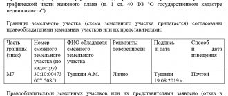
Next, the engineer is obliged to familiarize all owners of neighboring plots with the plan he has drawn up. Based on the results of the review, a boundary approval act is signed.
Often the customer on whose site the work was carried out needs to contact Rosreestr directly.
This occurs in the following situations:
- when land surveying was carried out before the site was registered in the cadastral register;
- the purpose of the work is to combine several sections;
- dividing the site into several plots.
In other situations, there is no need to visit Rosreestr. All necessary documents can be obtained from the cadastral engineer. To do this, you need to have all the papers confirming ownership, consent, etc.
What documents are prepared
Neither procedural nor substantive legislation establishes an exact list of papers required to establish the size of a plot. In order not to delay the procedure, it is better to provide all certificates of title to the land, buildings on it (whether it is a house or outbuildings), clarifying the specifics of the location of the site, as well as an identification document.
All originals and copies must be readable, scans must be in color. The photocopy of the passport requires a signature from the person confirming that it matches the original.
If there has been no increase or decrease in the plot, and the area of its territory simply needs to be clarified, this should be indicated in the application. Additionally, the engineer may require a number of other documents that will need to be requested from archives or government agencies:
- a certificate confirming the absence of utilities and electrical cables for any purpose;
- contracts of gift, sale or inheritance.
How to determine the boundaries of a land plot by coordinates
Sometimes land owners are interested in what the concept of “the boundary of a site has been established” means. If we talk about what is happening on the ground, then this is the usual installation of any objects (posts, fences, pegs, etc.). Using them you can visually determine the boundary of the site.
If we are talking about a cadastral map, then the situation is different. The boundaries are clarified by the cadastral engineer and he enters the coordinates into the cadastral register. They depend on the accuracy inherent in a given category of land. We'll talk about this later.
If all calculations were carried out correctly, taking into account a certain error, then there should be no difference between the boundaries on the ground and the boundaries on cadastral documents.
“Establishing boundaries” is determining their location on the ground and on the map. This procedure is the main task of the cadastral engineer.
There are two options for land surveying:
- In the case where land surveying has not been carried out on a given site, its boundaries are drawn according to established boundary signs. It would seem that it could be simpler. But in fact, the entire land surveying process takes quite a lot of time. The fact is that to correctly determine the boundaries of one plot, complete information about the demarcation lines and sizes of neighboring plots is necessary. This information is quite important, since it prevents the crossing of plot boundaries and the formation of any gaps. In addition, it is imperative to obtain the consent of all owners of neighboring plots with this procedure and its results. By and large, establishing the boundaries of a site and land surveying are one and the same procedure;
- Nowadays, very often controversial issues arise between land owners regarding their boundaries. If mistakes were made during land surveying and a “self-seizure” of someone else’s territory occurred, then the claims of the injured party are fully justified. Therefore, in order to avoid such unpleasant situations, a procedure is carried out to coordinate information on the boundaries of the site;
- When land delimitation work was carried out on the site, all information was already entered into the cadastres. As a result, the establishment of boundaries on the ground occurs on the basis of official data from cadastral documents. Although even in this situation, it is not always possible to avoid controversial issues with neighbors.
Nuances when clarifying boundaries
The land surveying procedure has its own characteristics that must be remembered so that the entire procedure is successful the first time:
- By law, a citizen is obliged to independently notify neighbors whose lands border his site about this seven calendar days before the engineer begins work. To avoid disputes when going to court, the land owner should ask neighbors to sign a document that is drawn up in free form and does not need legal confirmation. In this case, the main thing is not to find out the opinion of the neighbors, but to notify them of the date of arrival of the inspector so that he takes their decision into account.
- It must be remembered that any unauthorized change in the size of the site will be regarded by the inspector as a crime, which he is obliged to report to the relevant authorities.
- The decision to survey a plot of land can be made either by the owner or his representative by proxy. Family ties do not affect this issue.
- If the engineer confirms the illegality of expanding the neighbors' plots at the expense of the customer's land, he is obliged to call the district police officer and record the violation.
- Correction of violations is permitted pre-trial within the time limits established by agreement between neighbors.
Previously, the land surveying procedure was practically not carried out in the Russian Federation, but every year the number of conscious citizens increases.
How to determine the boundaries of a land plot by coordinates yourself
It is quite difficult to demarcate a site on your own. After all, the owner can only use simple means that are not intended for such work.
To achieve the best possible result, it is best to contact organizations that specialize in this activity.
As soon as the application to determine the boundaries of the area has been reviewed and formalized in an appropriate manner, specialists begin the preparatory stage.
The preparatory stage is:
- in obtaining documents from Rosreestr;
- in familiarization with information on turning points of neighboring areas;
- in studying the plan map;
- in advance arrangement of turning points.
Based on the results of the preliminary stage, a technical specification is drawn up. Further, representatives of the geodetic organization will act on this task.
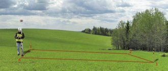
Geodetic work carried out directly on the site:
- taking measurements;
- checking the correctness of the preliminary plan;
- installing pegs at turning points.
Having completed their main task, surveyors draw up a special report. Next, the cadastral engineer checks the correctness of the actions taken and marks the boundaries of the site.
How to define boundaries?
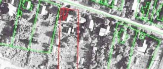
The boundaries of land plots are drawn based on information about turning points. These boundary lines separate adjacent plots from each other or separate a private plot from public lands.
Work to delimit plots is carried out on the ground and when drawing up diagrams of these plots. To draw lines directly on the site, it is necessary to obtain the results of the technical specifications.
The procedure for identifying boundaries is carried out in several stages:
- Temporary demarcation signs (pegs, posts) are put up. Sometimes permanent signs with inscriptions are immediately put up;
- A line is drawn between the pegs. Deviations are possible only in designated areas;
- The surveyor is responsible for drawing the line.
If the demarcation lines are not drawn correctly, unwanted displacement may occur. Next, you need to check the boundaries on the diagram and on the ground.
At the next stage, the data is transferred to Rosreestr. The person who submitted this application receives a document in paper form. Permanent demarcation signs are installed upon completion of all stages of work and their adjustment to the appropriate coordinates.
What are survey instructions?
In order to streamline land surveying and create uniform requirements for determining and delineating the boundaries of a land plot on the ground, instructions for land surveying were developed, approved in 1996.
The provisions of such a document are valid to this day and indicate the main points and rules that must be followed in order for the drawn up boundary plan to have legal force and all legal requirements to be met.
The instructions contain the grounds for carrying out land surveying, the procedure for preparatory work, standards for calculating and fixing turning points and permissible errors, provisions for drawing up documents and drawing up boundaries in kind.
How to determine the boundaries of a land plot of an apartment building
To clarify the demarcation lines between sections, you need to use information from the title documents. Information can also be found in documents on determining the location of the boundaries of the allotment established during its formation.
These instructions can be found in the letter of the Ministry of Economic Development of the Russian Federation dated March 19, 2010, number N D23-922.
According to the current version of the Federal Law dated December 29, 2004 “On the entry into force of the Housing Code of the Russian Federation N 189-FZ”, Art. 16, it is possible to form, carry out cadastral registration and free transfer of a plot of land on which an apartment building with accompanying real estate objects is located into the common ownership of apartment owners in the event that this land plot was not formed before the entry into force of the Housing Code of the Russian Federation or after its introduction.
In Part 1 of Art. 36 of the Housing Code of the Russian Federation states that the boundaries and area of the site under an apartment building must comply with the requirements of land legislation, as well as legislation on urban planning.
The area of a specific site and the location of boundaries within built-up areas are calculated based on actual land use, as well as the standards and rules that were in force during construction work on these areas (Part 4 of Article 43 of the Urban Planning Code of the Russian Federation).
Based on Part 9 of Art. 38 Federal Law of July 24, 2007 N 221-FZ “On the State Real Estate Cadastre”, clarification of the boundaries of a specific plot of land is carried out on the basis of the information that is in the documents on land ownership.
If such a document is missing, you can rely on the information that is in the papers relating to the formation of this site.
When none of the above documents are available, the boundaries of the site that have existed for 15 years or more are taken as a basis.
At the same time, these boundaries were fixed together with the use of natural and man-made objects, which also allows them to be used as a basis for determining the boundaries of the site.
In the case where it is possible to use a land surveying project, as well as information from any other document, the boundaries are determined precisely on the basis of these papers (Part 10, Article 38 of the Federal Law No. 221-FZ).
Area determination error
When determining the areas of plots, inaccuracies arise, which are characterized by errors. The error is the difference between the calculated area of the site and its true value.
For different methods of determining area, such errors may be different.
For the analytical method, the accuracy of area calculation depends solely on the errors associated with measuring the coordinates of turning points. In this case, the root mean square error (RMSE) of the analytical calculation method (mp) is determined by the formula:
mp= mt*√ P, where:
- mt — UCP location of turning points;
- P is the area of the plot.
As an example, we can take the accuracies mt acceptable for land surveying, which are determined by the relevant regulations (for example, the Appendix to the Order of the Ministry of Economic Development No. 518). These accuracies depend on the type of land.
So, for settlements this figure is 10 cm, and for summer cottages and gardening - 20 cm. Thus, for a garden plot of 600 sq. m, the accuracy of determining the area using the analytical method can be:
mpс= 0.2*√600=4.89 m.
When implementing the graphical method, its accuracy is affected by measurement errors, errors in drawing up a plan, and paper deformation. The relative error of this method ranges from 1:500 to 1:1000.
The accuracy of the mechanical method also depends on the errors in drawing up the plan (or map), and the condition of the paper on which the site plan is drawn. In addition, the accuracy of this method is affected by the size of the area. This method is not recommended for areas smaller than 10-12 cm2.
Under favorable conditions, the relative error in area measurements using a planimeter can reach 1:400.
We will tell you about how to lease a plot of land with the right to purchase. When buying an apartment you can get a tax deduction. Read more about this in our article.
Do you want to take ownership of a plot leased for 49 years? There are detailed instructions here.
How to determine the boundaries of a land plot without land surveying
If there is a need to determine the boundaries of a site, you can use the following methods:
- Seek help from cadastral engineers;
- Use data from Internet resources;
- Resolve the current situation together with your neighbors.
How does each method work?
Method one. Cooperation with a cadastral engineer
This method can be called the most correct. The only negative point is that you need to spend some money here.
In order for a specialist to complete his work, it is necessary to submit a special application to the cadastral chamber. The engineer, before working on the ground, collects all the information on the plot that is available in the cadastral chamber.
Based on the measurement results, pegs will be set. The permissible error is 20 cm, no more. A licensed specialist has the right to carry out work of this kind. As already mentioned, such work is paid. So, in the Moscow region, you need to pay about 8 thousand rubles to determine the boundaries of a site.
Method two. Internet
Rosreestr contains information relating to those areas where cadastral work was carried out. That is, all data must be stored on the website.
You must use the updated website address. Just follow the link provided, enter the required data in the specified fields and you will already have the necessary information.
Method three. Solving the problem with the help of neighbors
The boundaries that you want to define are also the boundaries of the people’s plots adjacent to your site. In this situation, without agreement with the neighbors, it is not possible to achieve the desired result.
What to do in this situation:
- Invite neighbors by written notice to a meeting;
- Contact specialists;
- Prepare a document including a drawing of this site;
- Coordination of data by signing the act.
Document processing
Law No. 221-FZ (clauses 7, 9, article 38) states that the boundaries of land plots can be determined based on coordinates and points. These coordinates can be found in documents on private property rights. In the absence of these papers, confirmation of the information is in the documents on the location of the boundaries of the site.
These documents include:
- Technical passport of the land plot;
- Documents on completed transactions;
- Certificate of ownership.
Important! If you do not have any of the documents listed above, then the location of the boundaries of the site will be determined by the boundaries of those objects that are located nearby and have existed for 15 years or more. These can be both natural and artificially created objects.
Coordination with neighbors
It should be understood that the border of your land will at the same time be the border of the neighboring one, therefore, when determining your site, you should carry out a coordination procedure with your neighbors.
To do this you should:
- Gather all interested parties (notify them in writing).
- Invite specialists who will carry out land surveying.
- Will draw up an act, which will necessarily contain a drawing of the site. Sign the act by all interested parties.
Cadastral passport for land and extract from the Unified State Register of Real Estate: what is the difference
Until 2021, there were two registers in Russia that collected data on real estate:
- GKN – state real estate cadastre;
- Unified State Register of Real Estate Rights.
The State Property Committee contained information about the main characteristics of the object: property boundaries, area, redevelopment, and so on. Any real estate had to be registered in the cadastral register, and in order to carry out any actions with real estate, for example, to sell it, it was necessary to issue a cadastral passport. The cadastral passport of the site was a basic document that contained the most important information about the object. It included the following data:
- Owner, category of land, its intended purpose, cadastral value, area;
- Cadastral plan of the land plot according to the corresponding cadastral number;
- Restrictions and encumbrances.
An extract from the State Property Committee was considered a cadastral passport for land.
The Unified State Register contained data on rights to real estate: who owned and owns the property, on what grounds, since when.
In 2021, these two registers were combined into one. Thus, the Unified State Register of Real Estate appeared. The State Property Committee and the Unified State Register were abolished. All information about real estate began to be stored in the Unified State Register of Real Estate, for which Rosreestr is responsible.
It became impossible to obtain a cadastral passport for a land plot. Instead, an extract from the Unified State Register came into effect.
Determination of parameters and area offline
Having the cadastral number of a plot of land or any other property, it is possible to determine:
- his address (coordinates),
- borders,
- square,
- other legal information.
All information is recorded by Rosreestr during the registration of the object. For this purpose, a nationwide database of cadastral numbers has been created.
All information on the cadastral number can be obtained in paper form in the form of a cadastral passport by an individual or legal entity directly from the Rosreestr division, the multifunctional center (MFC) . To do this, you must make an official request at these institutions or through the post office.
also
need to provide the following documents :
- check for payment of state duty;
- Russian passport;
- a document that certifies the applicant’s ownership of the land plot.
After submitting the entire package of documentation, the citizen receives a receipt, which will need to be presented to receive a cadastral passport.
The state duty for individuals is 200 rubles, for legal entities – 600 rubles.