Based on the current legislation of our country, we can say that the determination of the boundaries of a land plot (hereinafter referred to as land plot) is recognized as the only type of “land relations”. The rules and features of this procedure are described in detail in the Land Code of the Russian Federation.
How to find out the boundaries of your land plot is described by such legislative acts as: “On the state real estate cadastre”, “On land management”, “On approval of the rules for establishing the boundaries of real estate land management objects on the ground”.
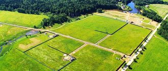
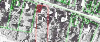
A land plot is a certain volume of land holdings, delimited in accordance with the laws of our country and included in the property. Official registration of the site is required.
Reasons for the procedure
This procedure is required primarily when the land cadastral registration authorities receive an application about changes in the location of the site. Sometimes applications are received whose purpose is to clarify the boundaries of the land of the owner who submits documents to these authorities. In rare cases, establishing the boundaries of land plots is necessary to resolve cadastral disputes.
The situation in which the boundaries of natural objects or objects of artificial origin were not precisely determined or information about them is not available in the cadastral registration service also requires approval. A special commission will be convened to clarify the boundaries, and then the information received will be entered into the state cadastre. Interested parties do not have the right to participate in the process of establishing boundaries; this is done to protect the rights of owners.
How to set storage boundaries
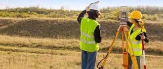
To establish boundaries, a land surveying procedure is required; it is part of cadastral activities.
It can only be carried out by specially trained cadastral engineers. There is no need to try to gain experience on your own, study instructions, you will still have to turn to specialists. They not only carry out surveying, but also draw up drawings and survey plans.
After all the work has been completed, the engineer prepares a report (landmark plan), which can then be submitted to Rosreestr.
How to register the real boundaries of the memory
In order to officially register the boundaries of a plot, you must register with the cadastral register. To do this, you will need to collect a package of necessary documents, go through the process of registration with the cadastral chamber and register with the Federal Registration Office (registration chamber).
What to do if boundaries are not set
Today, many land plots in our country do not have precisely defined boundaries. Dimensions can be described schematically or verbally, without having exact coordinates. This is due to the fact that previously the legislation did not require the owner to establish the boundaries of the territories.
A similar situation may arise if:
- information about coordinates and boundaries is not available in the state. cadastre;
- information about boundaries is determined with low accuracy (for lands of a specific purpose);
- information about the coordinates of some characteristic point of the border does not allow us to accurately determine its location.
What to do in this situation?
According to the letter of the Ministry of Economic Development dated December 22, 2016 No. 39682-VA/D23i, it can be concluded that when submitting an application for cadastral registration or making transactions with plots whose boundaries are not established, the owner will have to forcibly carry out a land surveying procedure and establish boundaries. Otherwise, during purchase and sale transactions, the buyer will not be assigned ownership rights.
Project for establishing the boundaries of land plots for actual use
Based on clause 9 of Art.
38 Federal Law “On the State Real Estate Cadastre”, we can draw the following conclusion. In order to determine the boundaries of a land plot, it is necessary to have documents confirming ownership of it.
If such a document is missing, then information is needed from the documents compiled during the formation of this site and the initial determination of its boundaries.
If such information does not exist, then the boundaries are determined based on actual use. They must exist in this place for at least 15 years. These can be fences and other artificial barriers, natural objects (trees, streams, ponds).
Establishing the boundaries of permanent inheritable land tenure
According to the Civil Code of the Russian Federation, Article 1181 on the inheritance of land plots, we conclude that the territory is inherited on a general basis and the right to own the plot is included in the inheritance. In order to accept an inheritance, no special permission from the authorities is required.
Upon receipt of an inheritance, water bodies, soil, plants, etc. located on the territory become property. No special measures are required to establish the boundaries of the inherited plot.
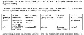
Important: You may have to carry out a coordination procedure with neighbors and draw up an act of agreeing on the location of the borders, and obtain the signatures of all interested people.
Judicial practice to correct cadastral errors and clarify boundaries
Judicial authorities refuse to satisfy claims regarding the invalidity of land surveying documentation, acts regarding cadastral registration, the obligation to make changes to cadastral documentation, when the requirements are based only on the fact that the applicant for a long time exploited the territory larger than the established cadastral documentation and title documents. documents, and (or) larger sizes are given in the documentation on the transfer of landholdings received before the execution of land surveying works.
The judiciary in such circumstances is guided by certain provisions. The reference to the large size of land ownership, recorded by documentation drawn up before cadastral registration, and the fact that land with the same area is fenced and exploited, is not decisive in resolving such situations due to the fact that this does not violate the rights of the applicant as owner of land recorded by the state real estate cadastre.
According to judicial practice, the actual exploitation of a larger territory violates the powers of the defendant, who owns the site used by the plaintiff. When considering such cases, an important role is played by cadastral documentation and documents that are the basis for the emergence of rights to land.
Coordination of land boundaries is also given serious importance. If the activities within the framework of this procedure were carried out on the basis of the requirements of the law, the judicial authorities refuse the requirements to clarify the boundaries for the reason that the powers of the landowner who filed the claim are not violated in this way.
The court rejected a claim filed on behalf of a gardening non-profit partnership, which sought to invalidate the registered right and restore the original boundaries of land ownership.
The state body proceeded from the fact that when carrying out boundary work on the land owned by the defendant, there were no violations of the approval procedure; the boundaries were established along the fence installed 18 years ago. In this regard, the powers of the applied partnership were not violated by land management work.
However, the courts satisfy claims regarding the exclusion from the state real estate cadastre of data regarding the coordinates, length, turning points of registered landholdings and the establishment of the boundaries of such territories in the coordinates determined by previous survey work or established during the examination, if the following points exist:
- there is documentary evidence that displays information about the applicant’s land ownership, and these documents are sufficient to establish its actual location, as well as the overlap of the boundaries of neighboring land, which was registered in the cadastral register earlier;
- during the cadastral registration of neighboring land ownership, there was a violation of the procedure for agreeing on land boundaries - there was no consent expressed by the plaintiff.
Take into account the presence or absence of an act on the file on the approval of land boundaries and on their removal to the area.
When the rights to land ownership arose on the basis of a purchase and sale transaction and the plot was legally registered in the cadastral register (the property was purchased after land surveying and cadastral registration), it will be difficult for the owner of such property to challenge the results of the survey of his land and clarify its boundaries .
Land dispute over borders
Often, land disputes and appeals to the courts may arise between neighbors regarding arbitrary land surveying. To avoid such cases, the law obliges the location of borders to be agreed upon with all persons interested in this.
It is required to invite a cadastral engineer, and based on his decision, come to an agreement at a special meeting or reach an agreement with each interested person individually.
Disputes with neighbors
Based on Article 39 of the cadastre law, it should be remembered that if the plots are in state or municipal ownership and citizens have a lifelong, inheritable, perpetual right to own them, then coordination with neighbors is not required.
Land owned by legal entities is not subject to disputes with neighbors. These legal entities should not be state or municipal. State-owned enterprises that have received land for indefinite use from the state do not need approval.
Neighbors do not have the right to object unless the subject of the dispute is common boundaries . In other cases, they carry out the approval procedure described above or apply to the courts.
Violation of the boundaries of the territory when installing a fence
Sometimes situations happen when citizens go to court with claims against their neighbors. A frequent subject of dispute is the installation of a fence by a neighbor on the plaintiff’s property.
Such a claim will be approved if initially coordination was carried out with all interested parties and a decision was made by the cadastral engineer, but the neighbor violated it. The fence will have to be dismantled and installed correctly, at the specified boundaries.
There is a situation where only one of the neighbors was the customer for the land survey. He invited a cadastral engineer, and he determined the boundaries in the interests of only one party, without agreeing with the adjacent owner. This makes the procedure illegal and invalid.
According to Article 60 of the Land Code, the owner can protect his interests and demand restoration of the position of the violated boundaries that were established before the land surveying procedure.
In case of disputes, the court may reserve the right to evaluate the actions of the cadastral engineer.
Jurisdiction of disputes regarding the establishment of land boundaries
In accordance with the Civil Procedural Code of the Russian Federation, the Arbitration Procedural Code of the Russian Federation and federal laws, disputes regarding the establishment of boundaries of land plots are not within the jurisdiction of justices of the peace.
They contain claims of a property nature that cannot be assessed, therefore, according to the decision of the Supreme Court of the Russian Federation, they are under the jurisdiction of a district court of general jurisdiction.
According to Part 1 of Art. 30 Code of Civil Procedure of the Russian Federation and Part 1 of Art. 38 of the Arbitration Procedure Code of the Russian Federation, the claim must be filed in the court located at the location of this site.
Statute of limitations
For each conflict concerning plots of land, the general provisions regarding the limitation period apply - it is three years. It begins to be calculated from the moment the applicant learns about the occurrence of circumstances when his rights began to be violated.
In judicial practice and consideration of cases concerning land disputes on adjacent plots, it is difficult to determine the exact date of violation of the applicant’s rights. In this case, the time for consideration of the claim is increased only by decision of the judicial authorities.
How to dispute
Since the law on land use has changed greatly in recent years, owners were required to register with the cadastral register.
Improper design of boundaries leads to disputes. They can be resolved either amicably or by going to court. To determine and clarify the boundaries of the land plot, the consent of all interested parties is required . If you can’t find a compromise, then:
- The owner has the right to hire a special company that will double-check the results of establishing boundaries, verify turning points, and check documents located in Rosreestr.
- Owners can jointly hire a geodetic company, which will conduct a special survey, determine the boundaries of the survey and install boundary signs.
If the dispute is not resolved, you will have to file a lawsuit.
Litigation claim
Any owner who has a documented right to a land plot has the right to go to court. You should study the land code in advance and determine whether the subject of the dispute is malicious intent or an error in the preparation of documents.
Personal presence at the trial is not necessary; a lawyer can do this. The defendant can be either a neighbor, the administration, a cadastral engineer, or a geodetic company.
A claim to correct an error in the location of boundaries may be rejected if the court sees errors in design or inconsistencies with reality.
You must provide:
- cadastral documentation;
- land surveying;
- deadline for processing these documents;
- confirmation of their legality.
The court's decision
The court may approve the claim if:
- formalities were violated (they did not notify neighbors, owners and did not coordinate land surveying with them);
- absence of an act on the approval of boundaries;
- there are violations committed by the cadastral engineer;
- During cadastral work, the rights of neighbors were violated.
Border disputes: judicial practice
A citizen filed a lawsuit against his neighbor.
He is outraged by the installation of a fence on his property and asks that the neighbor be obliged to remove his fence through a court order. The district court decided that there were no violations, citing the conclusion of the cadastral engineer, and refused to move the fence from the territory because it stands on the border specified in the engineer’s decision. The appeal was unsuccessful and the case reached the Supreme Court.
The Supreme Court ruled in favor of the plaintiff because it turned out that only one of the neighbors ordered the survey work. Both the neighbor and the cadastral engineer were notified of the presence of another interested party, but consent was not asked. The border was established based on actual use and it did not coincide with the border indicated in the documents.
The land survey was declared invalid and the fence was required to be removed.
The procedure for establishing actual boundaries
Occurs in several stages:
- Stage 1. An agreement is concluded with a special geodetic, licensed company.
- Stage 2. Land surveying is being carried out.
- Stage 3. A boundary plan is drawn up.
- Stage 4. The information received is sent and entered into the state real estate cadastre.
A site without boundary coordinates: what does this mean?
Such a plot is a property that does not have extreme points, so it is impossible to separate it from common or neighboring ones.
It is impossible to sell or rent or build a house on it. This may lead to lawsuits and will not allow you to obtain a cadastral number.