from 15,000 rubles
without own land surveying
In 2021, the cadastre service and the rights registration service merged, and a new structure of the State Property Committee was formed - a unified state real estate cadastre. In fact, since 2021, the term “cadastral error” has been replaced by “registry error”, however, today both terms are still used, they mean the same thing.
What is a cadastral (registry) error?
The discrepancy between the data of the state cadastral register and the actual data is a cadastral error. Errors can be very diverse, for example, information about a land plot may contain incorrect parameters for boundaries, rotations, location, etc.
Errors can be caused by typos or incorrect data provided. However, the basis for entering data about a land plot into the register is the boundary plan; if an error entered the register from the boundary plan, then most likely it was made by a cadastral engineer.
The most common causes of cadastral errors are:
- use of outdated equipment by cadastral engineers. Thus, the land surveying process becomes incorrect due to its implementation in a conventional coordinate system. As a result, a site is formed with boundaries that cannot be tied to the terrain;
- low level of qualifications and professional qualities of the performer, for example, some specialists simply ignore visiting the site and taking measurements;
- inattention of the surveyor, human factor;
- inattention of the Rosreestr specialist who entered information about the object.
According to the methods of elimination, all errors in the real estate register are divided into technical and cadastral.
The Supreme Court explained how to properly appeal a cadastral error
Lake instead of land
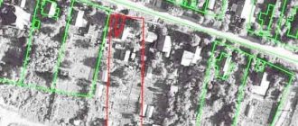
Displacement of plots due to the transition from one coordinate system to another is the most common problem in land disputes, says Dmitry Nekrestyanov, partner at Kachkin and Partners Kachkin and Partners Regional Rating. group Bankruptcy (including disputes) group Arbitration proceedings group Corporate law/Mergers and acquisitions 7th place By number of lawyers Company profile. Even in Moscow, if you open a public cadastral map, you can clearly see that many buildings are shifted in coordinates relative to the satellite image and go beyond the boundaries of their sites, states Anastasia Draskova, project manager of the Earth practice. Real estate. Construction" Infralex Infralex Federal rating. group Antimonopoly law (including disputes) group Arbitration proceedings (medium and small disputes - mid market) group Bankruptcy (including disputes) group PPP/Infrastructure projects group Land law/Commercial real estate/Construction group Digital economy group Corporate law/Mergers and acquisitions group Tax consulting and disputes (Tax disputes) group Family and inheritance law group Tax consulting and disputes (Tax consulting) group Criminal law Profile. At the same time, owners are actually deprived of the opportunity to pre-protect themselves from such cases, Nekrestyanov notes: “No matter how much you monitor the information in the Unified State Register, but at some point they simply change without your knowledge. And property that has existed for many years simply dissolves on paper.”
Case No. A15-4880/2015
Plaintiff: Makhachkala Seaside LLC
Defendant: Rosreestr for the Republic of Dagestan
Court: Supreme Court
The essence of the dispute: Is it possible to challenge a cadastral error by appealing against the action of a government agency (Chapter 24 of the APC)
Solution: Yes
Makhachkala Seaside LLC, which since 2011 owned a plot for the construction of a six-story parking lot in the capital of the Republic of Dagestan, faced a similar situation. In 2014, information about the boundaries of this land in the cadastral map changed due to the fact that the region switched from using the “local Makhachkala city” coordinate system to “MSK-05”. According to new data, in the maps the company’s site is located in a different place, moreover, it partially overlaps Lake Ak-Gel in Makhachkala. The Cadastral Chamber explained that the coordinates of the lands of Makhachkala Seaside LLC changed when they registered changes in the neighboring plot owned by Arsi CJSC.
Then the affected company decided to challenge the actions of the cadastral chamber, considering them “the issuance of a non-normative act by a government agency” (Chapter 24 of the APC). But to no avail: three authorities refused the applicant, and the appeal separately emphasized that when recalculating the coordinates, the area and configuration of the plaintiff’s site did not change (case No. A15-4880/2015). The District Court added that restoring the applicant's land plan to the old system would cause further confusion and would violate the rights of others. The first cassation considered that the demand of Makhachkala Seaside constitutes an appeal against the boundaries of the Arsi site, which should be considered in a lawsuit involving this company as a defendant. To substantiate this conclusion, the Arbitration Court of the North Caucasus District indicated that the boundary dispute cannot be resolved without involving the owner of the neighboring land in the case (clause 28 of the Review of the Supreme Court’s practice on challenging the refusal of cadastral registration dated November 30, 2021).
The error can be fixed without problems
The Supreme Court was deciding how to exclude from the cadastre information about previously registered areas.
“Makhachkala Seaside” did not agree with this conclusion and challenged it in the Supreme Court. Only Alexander Gladkikh, the plaintiff’s representative, came to today’s meeting. He assured that the plaintiff had chosen the right way to protect his interests. In addition, he emphasized that the restoration of the boundaries of their site would not violate the rights of “Arsi,” the applicant emphasized.
“But in fact, within the previous boundaries, your site is not occupied,” presiding judge Elena Borisova clarified.
“No, no one else uses it, so the error that has arisen can be corrected without problems,” Gladkikh answered confidently. The plaintiff added that their land does not even border the lake, and when recalculated, the plot turned out to be simply in the water.
In addition, Gladkikh drew attention to the fact that a complaint was filed with the Supreme Court by the owners of land that ended up in the new system adjacent to the Makhachkala Seaside property. Previously, the newly-made neighbors wanted to appeal to the city administration with a request to provide them with an adjacent plot. But according to new data, this land now belongs to the plaintiff - they cannot get it, the representative of the applicant noted.
Disputes about the cadastre: are legislative changes easier for applicants?
After listening to all the arguments of the plaintiff, the “troika” of judges retired to the deliberation room and a few minutes later announced the decision: the acts of the appeal and the district court were canceled in terms of recognizing the actions of the government agency as legal, but the issue of assigning the responsibility to the cadastral chamber to eliminate the violations committed by the Supreme Court decided to send for a new review back to first instance. Thus, the judges of the Supreme Court recognized that in such a situation the plaintiff chose the right method of defense.
Disputes about the correct method of protection
If the restoration of the boundaries of the plaintiff’s plot entails a change in the coordinates of the neighboring land, then such a case should be considered in the manner of claim proceedings, Anton Emelin, Aronov partner and partners Aronov and partners Federal Rating, is sure. group Family and inheritance law group Pharmaceuticals and healthcare group Criminal law group Dispute resolution in courts of general jurisdiction Profile. At the same time, this cannot be done when considering the case administratively, the expert explains: “Because restoring the previous coordinates will lead to the overlap of the borders of the two lands, which will not put an end to the process.” A similar approach is indicated in the joint Resolution of the Plenums of the Supreme Court and the Supreme Arbitration Court No. 10/22 dated April 29, 2010 “On some issues arising in judicial practice when resolving disputes related to the protection of property rights and other property rights,” clarifies Yulia Buzanova, partner at Land Law Firm Land Law Firm Federal rating. group Land law/Commercial real estate/Construction group Dispute resolution in courts of general jurisdiction group Arbitration proceedings (medium and small disputes - mid market) group Private wealth management 23rd place By revenue per lawyer (less than 30 lawyers) 47th place By revenue Company profile.
She explains that when considering cases according to the rules of Ch. 24 of the APC only assesses the legality of the actions of the authorized government body and does not examine the issue on its merits. The expert warns that choosing an inappropriate method of defense in a controversial situation can have a lot of negative consequences: “The plaintiff may miss the deadline to go to court, and the defendant will have time to make multiple transactions that will complicate the execution of the judicial act in the future.” The lawyer is confident that in such a case it would be correct to challenge the cadastral registration of the neighboring plot. One way or another, practice is in dire need of clear and clear explanations on how to resolve such disputes, Nekrestyanov sums up: “At the moment it’s chaos.”
Protecting the rights of the land owner by updating information about the location of the site
The procedure consists of several stages (takes from three to six months), including:
– measurements of the land plot;
– collection of documents;
– preparation of a boundary plan;
– coordination with all interested parties;
– implementation of cadastral registration.
When strictly followed, this procedure allows you to protect the copyright holder of the site and identify border crossings.
Source: Yulia Buzanova, partner at Land Law Firm Land Law Firm Federal rating. group Land law/Commercial real estate/Construction group Dispute resolution in courts of general jurisdiction group Arbitration proceedings (medium and small disputes - mid market) group Private wealth management 23rd place By revenue per lawyer (less than 30 lawyers) 47th place By revenue Company profile.
- Alexey Malakhovsky
- Supreme Court of the Russian Federation
A technical error. Correction method
The technical error lies in the contradictions between the electronic database (Rosreestr) and special cadastral documentation. These may be typos, inaccuracies in numbers and names.
This is the simplest version of the error, but in order to eliminate it, you need to inform about it.
How to do this correctly? The reasons for correcting technical errors are the following conditions:
- a personal statement submitted to the cadastral registration authority by the owner of the immovable property. This document is accompanied by evidence of the error and a detailed description of the problem;
- independent decision of the cadastral authority;
- the corresponding court decision, which has already entered into force.
Most often, to correct a technical error, the owner writes an application to Rosreestr; the period for consideration of the submitted application is 5 working days. At this time, the application is read, checked with the archival data of the cadastral file and the information is checked for errors. After the deadline, a decision is made to refuse or make specific changes. Usually the correction of technical errors does not meet with resistance, failures are very rare. However, if correction is still refused, you can go to court.
Why does the error occur?
The causes of errors in the cadastral map are most often three factors:
- Errors of a specialist, a cadastral engineer, who entered the coordinates of the site into the plan. In this situation, errors are initially contained in the registration data entered into the Unified State Register of Real Estate.
- Error, typo of the technical employee who entered data into the cadastral map program. In this case, the coordinates indicated in the documents are correct; erroneous boundaries are displayed only on the map.
- Errors in satellite video recording are not an error, since in the original version the information about the boundaries was entered correctly.
The procedure for correcting errors in the location of boundaries on a public cadastral map depends on the specific situation. In some cases, it is enough to simply identify an error, draw up the necessary documents and, based on them, make correct changes to the USRN database and the map. In other situations, the rights of the owner or controversial issues of the owners of neighboring plots will have to be resolved in court. Changes are made accordingly by Rosreestr and the map based on a court decision. Next, we will consider several types of errors and options for correcting them.
Cadastral error.
With cadastral errors it is more difficult - these are errors in the data and parameters of the property. The definition of a cadastral error is specified in Federal Law No. 218 “On State Registration of Real Estate,” which came into force on January 2, 2017 - this is the unreliability of information indicated by a specialist. Thus, a cadastral error most often appears due to the fault of the cadastral engineer.
In fact, it turns out that the documentation on the basis of which the real estate was registered contains an error. Elimination of cadastral errors is impossible without the participation of a cadastral engineer, because it is necessary to provide certified and accurate data about the property. How to do it?
- You can contact the company that performed the survey with an error with a request to redo the work. If she refuses, you have the right to sue her.
- If this is not possible, according to the law (based on the letter from the Ministry of Economic Development of 2009), any cadastral engineer can also help you and prepare documents to correct the cadastral error.
So, there is a property whose boundaries are included in the real estate cadastre, and it is known that this data contains an error, the cadastral engineer has provided you with an expert opinion on the error, what to do next?
- As practice shows, it is almost useless to independently apply for correction of the coordinates of your site. Everything seems simple and you have all the data in your hands? However, when forming such cadastral files, our specialists always warn about a very likely refusal. And then you will most likely have to proceed through the court.
- If cadastre errors were discovered during the surveying of a neighboring plot, you can correct your coordinates in the survey file of your neighbors. This is the most successful situation for correcting a cadastral error! Firstly, there is an interest on both sides: in order to correctly register your plot, your neighbor initiates correction of the cadastral error - the coordinates of your plot, and submits his plot for registration. Secondly, it's cheaper for you. For example, in our country, correcting a cadastral error costs only 5 thousand rubles. Such cadastral cases are registered quickly.
- The issue of increasing the area also often comes up when correcting a cadastral error. If a change in area is required, then get ready to immediately file the case in court. It will not be possible to send the case to the Rosreestr to correct the cadastral error and achieve correction if the area of the registered plot decreases or increases. Unfortunately, it is also very rarely possible to achieve a positive decision through the court. Perhaps the only way to solve this problem is to draw up a land purchase and sale or lease agreement with the local administration.
- Intersection of the site with forest territory. A very large number of land plots on the cadastral map have overlapping boundaries with forests. Previously, such cases were filed in court; they were protracted and hopeless cases. However, this summer a law on forest amnesty was adopted (Federal Law “On Amendments to Legislative Acts of the Russian Federation in order to eliminate contradictions in information from state registers”) and now land owners have priority; the case is sent to Rosreestr to correct the error. No need to go to court.
In any case, the owner of the property reports errors in the real estate cadastre through the State Services website or by personal statement.
Contact our company for help and don’t worry about the final result. We work on the principles of reliability and efficiency. Flexible pricing policy significantly increases the demand for our services. A large number of clients have been cooperating with the company for a long time.
What can serve as grounds for filing a case in court?
- refusal of the state cadastre to correct data at the request of the property rights holder;
- conclusion of a cadastral engineer about an error discovered during land surveying.
A registry error is an error that was made in the documents submitted to the rights registration authority and transferred to the Unified State Register of Real Estate.
A registry error should be distinguished from a technical error, since the procedure for correcting the error depends on this. It is very easy to correct a technical error; you only need to submit an application to Rosreestr. Fixing a registry error is much more difficult. First, you need to eliminate it in the documents in which it is admitted, and only after that contact Rosreestr. A registry error can be corrected without personal participation during complex cadastral work or if it is identified by the rights registration authority independently. A registry error is an error that is transferred to the Unified State Register of Real Estate from documents submitted to the rights registration authority: - from boundary, technical plans, a map-plan of the territory or a survey report. These mistakes were made by the cadastral engineer; - from other documents that were received, including through interdepartmental interaction. Such errors were made by persons and bodies that compiled and sent these documents. A registry error should be distinguished from a technical error - these are clerical errors, typos, grammatical, arithmetic or other similar errors that were made by the rights registration authority when entering information into the Unified State Register of Real Estate. As a result of such an error, information about real estate does not correspond to the data in the documents on the basis of which the information was entered into the register. For example, the technical plan of a building indicates one area, and the register indicates another. To find out what mistake was made, you need to compare the information about the property in the extract from the Unified State Register and the above documents. If they are different, then you need to correct a technical error. If the information is identical, this means that an error was made in the documents, that is, a registry error needs to be corrected. It is very easy to fix a technical error. For this purpose, an application is prepared and submitted to the rights registration authority. The rights registration authority can correct the error on its own if it discovers it. A registry error is more difficult to fix. First, the error in the documents is corrected and only after that - in the Unified State Register. A registry error is corrected by the state registrar only if documents are received that indicate the presence of an error and contain the information necessary to correct it, or a court decision that has entered into legal force. To do this, you need to: 1. first correct the error in the documents in which it was made. To do this, you need to contact: - a cadastral engineer, government agencies (local governments) or another person who made an error in the documents, and correct it; - to court, if it is not possible to correct it in the first way; 2.after this, an application is submitted to the rights registration authority and the corrected documents are attached to it. A registry error is corrected by making changes to the Unified State Register, 3. How a registry error is corrected without personal participation Rosreestr can correct an error independently only when it is made in the information about the location of the boundaries of a land plot. This is possible in the following cases: 1) if complex cadastral work was carried out. As a result of their implementation, the boundaries of land plots are clarified and registry errors in information about their boundaries are corrected. The updated information will be entered into the Unified State Register of Real Estate on the basis of the customer’s application and a map-plan of the territory, which is compiled based on the results of complex cadastral work 2) if the rights registration authority has identified the error independently. In this case, he makes a decision on the need to eliminate it and sends it to interested parties (authorities) no later than the next working day. It will indicate the essence of the error and why it needs to be corrected. If you receive such a decision, we recommend that you evaluate whether you need to correct the error, as this may incur additional costs. If you decide to correct it, then you must first correct the error in the documents and then contact Rosreestr. If the documents necessary to correct the error have not been submitted (application for state cadastral registration in connection with a change in the basic information about the property and the boundary plan), then after three months from the date of sending you the decision, the rights registration authority makes changes to the Unified State Register of Real Estate without the consent of the legal owner of the land plot , if the authority has the necessary documents, materials and conditions are met. Before the expiration of the three-month period, you can apply to the registration authority to extend the period, but not more than three months. Changes can be made if after this the area of the land plot does not differ from its area indicated in the Unified State Register of Real Estate by more than five percent. When correcting registry errors, Rosreestr also enters into the Unified State Register of State Registers information about the location of boundaries (coordinates of characteristic border points) of adjacent and (or) non-adjacent land plots, and also enters information about the area of land plots. In this case, a boundary or technical plan for the corresponding property is not prepared. Entering information into the Unified State Register of Real Estate about the location of the boundaries of a land plot, buildings, structures, and unfinished construction projects on the site does not prevent the state cadastral registration of a property on the basis of documents submitted by the owner after Rosreestr entered such information into the Unified State Register of Real Estate. This rule also applies when correcting registry errors in describing the location of land boundaries. It should be noted that in practice, difficulties arise when making such changes to the Unified State Register. Thus, the new coordinates of the characteristic points of the boundaries of the land plot, which must be entered into the Unified State Register of Real Estate, may be unknown. In addition, Rosreestr does not always have the opportunity to establish them, since the procedure for independently determining them has not been established for registration authorities. A registration error is corrected by the rights registration authority within five working days from the date of receipt of documents that indicate its existence and contain correct information, or a court decision that has entered into legal force. After this, a notification is prepared and sent within the following period: 1) within three working days after the error is corrected; 2) within five working days, if Rosreestr corrected the identified registry error independently. The notification is sent to the email address specified in the application by indicating a link to the electronic document posted on the Rosreestr website. If the error was corrected without a statement, then the link is sent to the email address contained in the Unified State Register of Real Estate. A paper notification will be sent only if there is no email address in the application or the Unified State Register. In this case, it is sent by mail to the address specified in the application, and if the error was corrected without it, then to the address available in the Unified State Register of Real Estate.
When is it necessary to correct cadastral errors?
If the information about your site is incorrect, this can lead to a number of unpleasant consequences. First of all, these are restrictions on property rights, the impossibility of registering buildings, incorrectly calculated taxes and duties, and disputes with neighbors. Sometimes the owner benefits from the mistakes made, and for this reason he does not take any action. However, sooner or later there will come a time when the error will need to be corrected and it’s good if you have time for this. We recommend correcting errors immediately upon discovery.
How much does it cost to fix a registry error?
The minimum cost for correcting a cadastral error by our specialists is indeed 5,000 rubles . In what cases do we work at these prices?
- in the case of surveying public land in your village, if a cadastral error is detected, we will correct it for 5,000 rubles;
- If, during the survey of a plot adjacent to yours, we discovered a cadastral error, we can correct it without opening a new cadastral file, in this case, correcting the cadastral error will cost you 5,000 rubles.
Separately, we note that Rosreestr is very reluctant to correct a cadastral error initiated by the owner himself. Most often, such a case is refused, and the change in boundaries is considered unfounded. The cost of correcting the error in this case is equal to the cost of land surveying - from 10,000 rubles for one plot. At the same time, our specialists will warn about a possible suspension of the case and recommend correcting the error when surveying your neighbors or public land, or going to court.
If it is necessary not only to shift the boundaries, but also to change the area of the site, no matter up or down, the suspension of the case is almost guaranteed. Such a request can only be resolved through court, and even there it is very rare to achieve a positive decision.
It happens that part of a village is placed on the cadastre incorrectly and a large number of areas need to be corrected. Then you can draw up a land surveying project. This is a fairly expensive undertaking, requiring the consent of a large number of participants, but sometimes this is the only way to correctly correct all boundaries on the cadastre, without moving fences installed many years ago.
Our specialists are ready to answer your questions, call us: +7
Error - violation of the boundaries of several plots when one owner refuses
If we present the previous mistake, but with the condition that the owner of the problematic 8th plot refuses to make adjustments to the general plan and Rosreestr. The refusal manifests itself in the form of a refusal to sign the act, which is drawn up by the cadastral engineer. It is the act that serves as the reason for carrying out a new survey and adjusting the data.
The problem is that if one of the participants refuses, Rosreestr will not give consent to make changes. It will not be possible to solve this problem out of court. What should be done:
- the owners of the plots file an application with the court with a claim to cancel information about the boundaries of the plot, which on the map overlaps with all the others;
- in addition to all participants in the claim, you can involve an official representative of Rosreestr, who will confirm the fact of the error;
- Supporting documents should be attached to the claim - extracts from the Unified State Register for all plots, a copy of the boundary plan.
Changes to Rosreestr in this case are made by court decision and without the consent of the refused owner.
Errors on the public cadastral map can cause a conflict between the owners of neighboring plots. In addition, when carrying out communications (electricity, gas, water) to sites, contractors also use map and Rosreestr information, so serious difficulties may arise here too. If you see a discrepancy between the actual boundaries and the cartographic location of the site, it is better to make changes in a timely manner.
Text: Irina Maslyukovskaya