Home / Real estate / Land / Land survey / Boundaries of the land / Changing the boundaries of the land
Back
Published: March 26, 2017
Reading time: 12 min
0
1184
Disputes regarding rights to land plots and the boundaries established on them are quite common in current judicial practice.
Their occurrence may be due to various reasons: the lack of a land surveying procedure, boundary signs, or an actual violation of the property rights of one of the owners.
In any case, to establish the real boundaries of real estate, a special procedure will be required - restoration of the boundaries of the land plot , the features of which will be discussed further.
- Legislative regulation
- Essence and reasons for the procedure
- Rules and procedure for restoration Preparatory stage
- Field stage
- Office stage
Legislative regulation
Restoration of the boundaries of the land plot is carried out in accordance with the general rules and requirements established for cadastral and geodetic work.
In particular, general legislative regulation is carried out by the Land
Code of the Russian Federation and Federal Law “On Cadastral Activities”.
In addition, the provisions of all other regulations that affect this procedure are taken into account.
These may be government regulations, orders of individual ministries, federal and regional laws, state standards and regulations, etc.
The main responsibility for compliance lies with the contractor, who must be familiar with all legal requirements.
If a claim is drawn up and filed in court, the provisions of the Civil Procedure Code will apply. In particular, they will concern the rules and requirements for drawing up a claim, the features of its filing and the entry into force of a court decision.
Grounds for going to court when imposing boundaries of land plots
According to the norms of the current Russian legislation, the resolution of such issues falls within the competence of courts of general jurisdiction. Address the statement of claim to the district court, based on the location of the land ownership.
Situations in which a case is subject to consideration in court proceedings may be as follows:
- the presence of a dispute regarding boundary boundaries between owners of adjacent plots;
- identifying errors in the process of boundary work;
- detection of the fact of imposition during the procedure for registering land ownership or a transaction for the alienation of an allotment;
- obtaining a refusal from the Rosreestr authorities regarding the elimination of the error.
Essence and reasons for the procedure
Restoring the boundaries of a land plot is a procedure during which the legal boundaries established in the relevant documentation are restored on a property.
Another name for this procedure is the removal of the boundaries of the site in nature (on the terrain).
This is due to the fact that during the work, specialists not only determine where exactly the boundaries of the land lie, but also actually fix them, using special boundary signs.
The most common motive for restoring boundaries is to protect the property rights of the property owner, including from encroachment by third parties. In particular, if disputes arise with neighbors regarding the boundaries of the site, this procedure cannot be avoided.
Their restoration may be necessary in the following cases:
- The plot is subject to sale, and the new owner wants to see the specific boundaries of the transaction object. Fixed boundary markers are a more reliable and visual way of establishing them than simply fixing them in documents, so in this case it is impossible to do without installing boundary markers.
- Boundary signs were not installed on the plot or were damaged (lost). These signs are the main identification elements by which the boundaries of the site are determined. If for some reason there are neither these signs nor other means marking the boundaries (fence, fencing, plants), the owner will have to order a procedure for removing the boundaries to the area.
- The owner had disputes with the owners of adjacent plots. For example, one of them occupied part of the owner’s land or, conversely, believes that it was his share of the land that was appropriated. If it is not possible to agree on a voluntary resolution of the issue, the only option left is to go to court. However, before this, it will also be necessary to restore the boundaries on the ground.
In some cases, it would be useful to carry out a restoration procedure before construction on a site, as well as in the event of any transformation (division, merger).
This will maximize the protection of the property rights of both parties and prevent future possible disputes regarding the boundaries of the land.
How can a lawyer help in this situation?
Land disputes are one of the most difficult in legal practice because... they are associated not only with many legal provisions, but also with the solution of engineering issues. Therefore, even if it is necessary to perform a relatively simple action - to establish a territorial zone for a land plot - it is worth seeking the help of a land law lawyer. This specialist will conduct an initial analysis of documents, assist in the implementation of cadastral work and ensure the protection of rights in the legal process. In the latter, it is his professional knowledge and practice that are of great importance for the successful resolution of the dispute, which will allow the owner to restore his rights.
With respect to you and your business,
legal
Rules and procedure for recovery
The procedure for restoring boundaries falls under the category of geodetic work. This area of activity is quite complex and can only be carried out by qualified specialists.
The procedure itself can be divided into three stages:
Preparatory stage
At this stage, the owner organizes the process of restoring boundaries, namely:
- is looking for a company or contractor that could perform this type of work;
- finds out the most detailed information about the potential contractor (prices, available equipment, work experience, error rate, etc.);
- concludes a contract with a company or individual specialist with a detailed description of all the terms of the transaction;
- prepares a package of necessary documents and provides them to the contractor;
- makes an advance payment for the work.
After this, he gives the prepared documents to the cadastral engineer, who carefully studies them.
If the necessary papers are not available (in particular, an extract of their Unified State Register is mandatory), some of them can be issued by the executing company.
Only after a thorough study of theoretical data does the specialist proceed directly to practical work.
Field stage
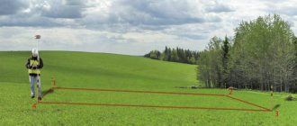
At this stage, cadastral engineers, using special equipment and coordinates indicated in the extract for the plot, determine and fix its turning points (these are points that show the direction of movement from each boundary of the plot).
These points are fixed using special means - boundary signs, which can be either temporary or permanent. Depending on the wishes of the owner and the individual climatic and soil conditions of the area, they can be made of either metal or wood.
The basic rules regarding their use are enshrined in a special document - Order of the Ministry of Economic Development of the Russian Federation dated December 31, 2009 N 582 “On approval of types of boundary signs and the procedure for their installation (laying).” In the future, it is advisable to preserve these signs, since they will be the main identification elements when determining the boundaries of the site. Alternatively, they can be replaced with a fence or railing along each side of the property.
Office stage
This is the final stage where the performer prepares some
documentation. In particular, this is the act of placing boundaries on the ground, as well as a photo report of the work done. In addition, an acceptance certificate for completed work can be drawn up and signed by the parties.
After this, the owner will have in hand all the documents necessary to resolve the dispute (if this is the reason for the work). Therefore, the next important step is to go to court, for which the owner will need to draw up a statement of claim.
If you fail to pay taxes when renting out an apartment, you may incur serious administrative liability. Single mothers can get a mortgage on preferential terms. Read more about this here.
A sample deposit agreement for the purchase of land can be downloaded in our article.
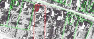
How is the overlap of land boundaries identified?
Detection of the fact of overlapping boundaries of adjacent plots usually occurs at the moment:
- carrying out land surveying work (which is carried out at the time of registration, consolidation, redistribution or division of land ownership);
- when registering real estate.
If an overlap is discovered during land surveying, the cadastral engineer draws up a conclusion that reflects the detected error and indicates which plot boundaries were violated, as well as why this happened. If the discovery occurred during registration, then the specialists of the competent authority make a decision to suspend or refuse to register the property due to the fact that a cadastral error has been identified.
The basis for pre-trial or judicial consideration of the issue can be either a conclusion drawn up by an engineer or a refusal issued by the Rosreestr authority.
Statement of claim when imposing boundaries of a land plot
The text of the statement of claim must reflect information regarding:
- data of the participants in the process - the plaintiff and the defendant;
- the circumstances that caused the conflict situation regarding the imposition of boundaries;
- the date of receipt of the rights of the owner of land ownership and the form of the existing right;
- a statement of the situation in which you became aware of the fact of imposing boundaries and the legal consequences of the mistake;
- the measures you have taken to resolve the dispute before going to court, including the appropriate documents;
- the defendant's actions in relation to the situation;
- requests to the judicial authority to satisfy the claims in full.
Consideration of a case in court on the imposition of land plots
After the case materials have been reviewed, the participants speak in the trial. To clearly substantiate your position, prepare an evidence base. The debate takes place with the participation of witnesses who can confirm that the plaintiff’s rights have actually been violated. A special role is given to the cadastral engineer, who will indicate all the reasons that served as the basis for the violation of your rights.
If the defendant is an employee of the Rosreestr body, he substantiates the presented refusal to correct the error. The application for refusal may be a formality based on the position of the law, and requiring the availability of an appropriate court decision.
When the defendant is a citizen who has violated established boundaries and caused property damage by his act, then a statement of claim can be filed against him demanding compensation for material damage.
In such circumstances, confirm in detail the stated amount of the claim using:
- expert opinions;
- certificates issued by an independent appraiser;
- documents confirming expenses.
You can restore your violated rights if the court rules in your favor.
Price
The price for performing the work is established by the contract concluded by the parties. The cost depends on the following factors:
- location of the allotment;
- area of the site;
- configuration and number of coordinate points;
- relief features;
- local conditions for paperwork;
- season of work;
- presence of disputes with neighbors.
Taking into account the listed nuances, the owner may need an amount from 5 to 8 thousand rubles. In Moscow and the region, the cost may be higher, or if there are additional features that affect the price.
Making a decision in court on the imposition of land plots
A court decision is made not only on the basis of the provisions of the law, but also according to the objective position established as a result of the examination of the submitted documents and debates of the parties.
The court decision is issued to the participants in the form of an extract.
This paper acts as a title-establishing and law-altering document. According to the position of the court given in it, the violated boundary boundaries of land ownership are restored, or they remain in their current state.
In addition to the above, this paper is recognized as a resolution for Rosreestr, on the basis of which the specified body is charged with the obligation to execute the court decision and carry out state registration.
Was the Recording helpful? No 35 out of 36 readers found this post helpful.