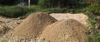
Almost every owner of a plot wants to “cut” at least a small piece of land adjacent to it. Are there always legal grounds for this? Each plot has its own details and the area is one of the main ones. Even if a land surveying procedure has not been carried out on the site and it does not have designated boundaries, after its implementation the size will still be established. In theory, increasing the area of a land plot is almost always possible. But for this it is necessary not only to comply with the procedure stipulated by law, but also to have legal grounds (the same legal status of the plots and VRI, the permission of the owner, it can be a municipality or an individual, the absence of registered prohibitions and encumbrances, etc.).
Here it is important to understand at the expense of which lands the size of the plot will increase, because, most likely, nearby plots also have their own boundaries. It is important to formalize the procedure correctly and, of course, the rights and legitimate interests of third parties must not be violated.
Legal regulation
Any issue of a legal nature is regulated by legal norms. In this case, if we are talking about increasing the area of land plots, the main acts are:
- Federal Law No. 221-FZ of July 24, 2007 “On cadastral activities.” This act defines the concept of boundaries of land plots and establishes a procedure for changing and clarifying them;
- Land Code of the Russian Federation . Determines the main points relating to the regulation of land relations, including the issue of land registration;
- Civil Code of the Russian Federation . Defines the principle of freedom of contract, as well as the main parameters of a purchase and sale or gift agreement. It can be used in cases where the area is increased through the purchase or other acquisition of land from neighbors.
We should not forget about the possibility of applying penalties to citizens for violating current legislation. Thus, Article 7.1 of the Code of Administrative Offenses of the Russian Federation provides for liability for squatting of a land plot.
Link to document: “On cadastral activities”
Link to document:
What documents are required
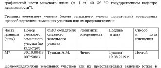
Clarification of the boundaries of a land plot registered in the cadastral register is carried out on the basis of acts, decisions and certificates that confirm the allocation of a specific area in this particular place. The work is carried out on the basis of information from title documents. Additionally, information is used from documentation determining the location of land ownership at the time of its formation. In the absence of such, clarification is carried out along the boundary determined 15 years ago or earlier and fixed using artificial and natural objects as landmarks for turning points.
Setting the boundaries of a land plot is carried out on the basis of the following documents:
- situational plans from technical passports of real estate objects prepared by the technical inventory bureau and technical accounting authorities;
- documents on forest management and planning and cartographic schemes, which are stored in the archives of regional government bodies, construction organizations, housing and communal services;
- master plans and schemes for the development of territories of local government entities;
- design documentation for the development of gardening partnerships.
In judicial practice, there are cases when plans developed by municipal unitary organizations before the object was registered in the cadastral register, decisions of state bodies on the granting of land ownership for use were accepted for consideration.
You can also provide an act for the right to perpetual use of land, extracts from meetings of trade union committees and other title documents with information about the size and position of land ownership.
What is an increase in area and what is it for?
Each owner of a land plot, in theory, has the opportunity to increase its size.
Such a need may arise for various reasons, for example, it is planned to build a house or outbuilding, but the area of its own plot is not enough, or the owner wants to start growing fruit trees. The purpose of use is not of fundamental importance, but it should not contradict the intended purpose of the attached area. An increase in area is a change in boundaries due to adjacent territories in the direction of their growth . This can be implemented in different ways, depending on the circumstances:
- by purchasing the territory that is nearby;
- land redistribution;
- in the process of clarifying boundaries;
- during the land surveying procedure;
- using the concept of cut-offs.
Some options involve paid conditions, for example, you can buy out part of your neighbors’ plots and then add them to yours. But sometimes the procedure does not require special investments, except for the costs of registration and land surveying.
Redemption of neighboring territory
You can buy the territory that is nearby, regardless of who owns it.
The main condition is that the ransom must be voluntary; no one can be forced to participate in the procedure, since this will already be considered an offense. Quite often in practice, municipal land is purchased. For example, there is an ownerless object nearby or directly owned by the administration.
The first step of a person who wants to increase his legal possessions is to contact the administration with an application to conclude an agreement. The application is considered within a month from the date of application; the result of the application will be an act that contains consent or refusal, on the basis of which the contract is concluded.
In some cases, boundary work is necessary. For example, if the neighboring plot is ownerless and its boundaries are not properly defined. This must be done after receiving consent from the administration by contacting a cadastral engineer.
If the neighboring plot belongs to a private person, the agreement is concluded on the basis of the expression of the joint will of the parties.
Clarification of boundaries
Clarifying the boundaries allows you to increase the owned plot when it is possible to prove that a person actually has less land than he should have according to the available documents or the law.
The procedure will be possible only if the increase in land area does not violate the rights of other persons.
To clarify, surveying is carried out. If during the process it becomes clear that the land plot can be increased without violating someone’s rights, then the procedure will be possible. If it turns out that there are contradictions, they can be resolved either by concluding an agreement or through court.
Redistribution of plots
Redistribution means “cutting off” part of neighboring plots. That is, in simple terms, there are several plots, each with its own established area. The redistribution procedure allows you to change the size of each, for example, one to increase, the other to decrease.
When redistributing land, a number of circumstances must be taken into account:
- lands must be privately owned;
- the plots must have a specific purpose: individual housing construction, private plots, or be part of the SNT;
- the existence of old plots ceases and new ones are formed.
Redistribution of plots that are owned by the municipality or the state is also possible.
Relations related to redistribution are regulated by the Land Code, based on Article 11.7, as well as Chapter V.4.
In the process of surveying
Part of the land plots was allocated to citizens back in Soviet times. The owners may either have no documents at all or be of an old type that is no longer in use.
Title documents do not always correctly reflect the real property and legal status of a person. Sometimes the actual and documentary area differs.
In the process of cadastral work, the size of the plot may be increased. But there is also a possibility that the size will be reduced. In fact, the coordinates will remain the same, but the newly issued documentation will already correspond to reality.
Trimmings
Expansion of the site is also possible using so-called extensions. The bottom line is this: when carrying out land surveying, the size can be increased by 10 percent from the original, provided that the neighbors agree to such a procedure and this will not violate the interests of other persons.
It is important that all interested parties give their consent to the procedure.
Otherwise, it will not be possible to increase the boundaries of the site in this way.
Possible problems
Despite all its usefulness, land surveying is a procedure during which you may encounter a number of problems that will make further land registration much more difficult. In some cases, until the problem is completely resolved, it will not be possible to consolidate the results of land surveying at the official level.
The main problems that may arise during surveying include:
- Cadastral error - if it directly affected the result of land surveying, for example, the nodal points by which the boundaries of the site were established were incorrectly determined, the procedure will have to be repeated. Usually in such cases it should be carried out at the expense of the performers who made a mistake the first time.
- The presence of insurmountable obstacles to drawing the boundaries according to the plan - this could be a permanent fence on the border, put up by one of the neighbors and interfering with the procedure due to the impossibility of a full topographic survey, the emergence of a new body of water along which the border now partially runs, and similar cases. Then you will first have to draw up a new boundary plan and draw the boundaries of the site in a new way, and only then clarify them directly with measurements.
- Neighbor's disagreement with survey results. It should be noted here that situations are different, and the simple absence of a signature from one of the neighbors in the land surveying act will not become an obstacle to registering the results: after all, the neighbor could simply not show up for the procedure, or refuse to sign the act without any legal grounds. The main thing is to warn him in time that you will be conducting land surveying, and then it’s his choice. The real problems will arise if the matter has progressed further and a neighbor has filed a claim against you, then the issue will have to be resolved in court.
- It is required to change the area of the plot - the cadastral engineer will have to justify the reasons why it is necessary to change the area of the plot, and based on how convincing his justification was, government agencies will decide whether to give consent to this.
Changing the plot size
Whether it was necessary to “cut” new land, a cadastral error was made, or the boundaries were drawn in a new way due to the impossibility of leaving them in the same form as they were before - in any case, this will affect the area of the site.
After the change is made, both its actual area and that only passing through the documents may become different, if previously it was simply measured incorrectly.
It may differ either up or down - and in any case, this difference will need to be formalized, which adds hassle to the registration of land.
How to legalize an increase in area
The procedure will vary slightly depending on the method chosen, as well as the specific circumstances. In general, you first need to obtain a document on the basis of which the change in area will be carried out. It could be:
- agreement with the owner of the neighboring plot;
- agreement with the administration;
- land surveying act agreed upon with neighbors.
Further, such a document is subject to state registration. If we are talking about concluding an agreement with a neighbor, then it will need to be registered with Rosreestr. If the increase in area is carried out on the basis of cadastral work, then the approval act is transferred to the cadastral chamber, after which the right to the new plot is still registered in Rosreestr.
What documents will be needed
The procedure can only be implemented if the owner collects a complete package of documentation:
- application for amendments;
- passport or other identity document;
- cadastral plan of land plot;
- agreement on redistribution of plots.
The documentation package will change every time. The main thing is that it contains a document on the basis of which the change in area is made, a diagram of the allotment and a document about the identity of the applicant.
Summary of the procedure
As a result of an increase in land plot, the old land plot actually ceases to exist, but at the same time a new one is formed, with different characteristics, first of all, with an increased area.
As a result, the owner receives an obligation and begins to bear the burden of maintaining the new site. Its cadastral value increases, and therefore the amount of tax paid.
The owner initiating the redistribution procedure must be aware that from the moment the new plot is formed, he begins to bear responsibility for the enlarged plot in full.
Consequences of not having a set boundary
If the extract from the Unified State Register contains a record that the boundary of a plot of land is not established in accordance with the requirements of land legislation, you should think about it. This applies to the potential owner and the upcoming land purchase transaction. The buyer must understand that the absence of established boundaries of the site does not guarantee compliance with the rights of the owner regarding the passage of the boundaries of the site. This often leads to disputes that escalate into litigation.
If the buyer purchases a plot of land without established boundaries, he will have to establish them at his own expense. The legislation establishes that from January 1, 2021, when concluding any administrative transactions, the presence of fixed boundaries will be mandatory. It will be impossible to sell, donate, rent out or inherit a plot of land without a land surveying procedure.
Practical features
In practice, an increase in area is most often carried out through a redistribution procedure.
The allotment is increased at the expense of nearby territories that belong to the state or municipal fund. In this case, you need to contact the owner. Most often this is a municipality. In most cases, he will agree to redistribution if the site is not used in practice and does not have any restrictions.
It is important that the redistribution is carried out free of charge. In essence, citizens simply annex plots that are nearby and not used by anyone.
If conflicts arise, for example, with neighbors who do not want to sign the agreement, you can try to resolve it in court. This is done through going to court, by filing a statement of claim.