The procedure for clarifying the boundaries of a land plot rests with the owner. Each owner of a subsidiary farm or plot for individual housing construction must have a boundary plan of his plot in his hands along with other documents for the land. According to the data obtained after the topographic survey, the owner has the right to install a fence on the site and use it in accordance with its intended purpose. However, neighbors do not always agree with the resulting boundary plan. Is it possible to challenge the results of land surveying? How to do this, and in what cases should we hope for success? This will be discussed further.
Causes of border disputes
A land plot for individual use can be called a part of land that arises as a result of dividing a large plot into small ones with the boundaries recorded in the register (primary surveying, carried out by the municipality or the owner). It must be registered as property and registered in the cadastral register, assigned to a specific land user.
A site - especially if it is old, has existed for a long time and has even been inherited - during its operation it can change its boundaries: an unsuccessfully installed fence, earthworks, construction, etc. Boundaries can also be shifted intentionally.
Clarification of the boundaries of a land plot can initiate:
- owner;
- tenant under a long-term contract (more than 5 years);
- judge when resolving a dispute.
Typically this procedure is carried out in connection with:
- with purchase and sale or exchange transactions;
- with dividing the plot into smaller ones or allocating parts for the new owner;
- with the combination of the plot with the neighboring plot.
A separate point is the resolution of conflicts with neighbors. Typically, the question of legitimate land surveying arises if:
- a neighbor put up a permanent fence, occupying someone else's territory;
- he built a building that took over the area of the neighboring plot;
- the owner arbitrarily appropriated part of the common territory: he seized a section of the road, the adjacent territory, in a word, he prohibited access to public land.
If, when trying to point out the discrepancy between the actual boundaries and the legal ones, a neighbor provides a dubious boundary plan, it is worth trying to challenge it in court and restore the integrity of the boundaries of your property.
What it is
Land surveying legally establishes the boundaries that all plots of land must have. For a long time, land could be given out without title documents; neighboring plots were not divided along borders. As a result, such owners now cannot even prove their rights, nor can they prove the exact area of their property.
If no official land surveying work has been carried out, controversial issues regarding land plots are inevitable; many will want to add a few more centimeters and even meters to their plot. The lack of land surveying is therefore revealed most often when a conflict occurs between the owners of neighboring territories.
ATTENTION! When surveying land plots, boundaries are established officially and documented, and therefore all disputes between neighbors over additional area are resolved.
To order a land surveying procedure, you need to submit an application to the authority responsible for land registration and call the appropriate specialist.
Which boundary plan is considered correct?
The procedure for carrying out and approving geodetic work is clearly specified in Federal Law-221 dated July 24, 2007 :
- work can only be performed by a licensed organization, as well as a specialist entered in the register of cadastral engineers;
- Land users of all neighboring (adjacent) plots are notified of the planned measurements. If their contacts are unknown, the owner must take care of finding them: obtain information from the cadastral chamber and send registered letters;
- measurements are carried out with a mandatory visit to the area, using special instruments. The length, width, angle of inclination, terrain, proximity of public facilities, reservoirs, and features of the surrounding surface are measured;
- based on the results, a site survey report, boundary or technical plan is drawn up;
- it must be signed by land users of adjacent plots;
- After signing, the plan is registered in the cadastral chamber.
Who carries out the work
Almost every site has adjacent boundaries with neighboring ones.
In recent years, the allocation of plots has been carried out with their land surveying; the owner must register his property with Rosreestr, and this is impossible without land surveying work. And only those owners who received plots decades ago sort things out among themselves before these disputes. How can you challenge your neighbor and protect yourself from land claims in the future? You need to call a cadastral engineer who has a license to perform the work.
Is it possible to demarcate the site yourself? Such activities are carried out only by licensed specialists; the result of their work has weight for the cadastral service and for Rosreestr.
ATTENTION! It is imperative to check the license of the engineer who will come to the site to determine its boundaries.
Such a responsible procedure as land surveying is not only carried out with permission, but its implementation is also controlled by the Committee on Land Management and Land Resources.
When can a plan be challenged?
The most common situations that cause a dispute:
- if the clarification or determination of boundaries took place without the participation of other interested parties other than the owner: for example, without neighbors. The document does not contain their signature indicating agreement with the results of the examination;
- violation during the initial survey: for example, if according to the documents the boundaries of the site are located in a completely different way than the actual ones. The site must be removed from the cadastral register, the initial survey must be carried out again, and only then transferred into ownership or long-term lease;
- the neighbor has arbitrarily occupied territory that is not his own and does not want to resolve the conflict pre-trial;
- a technical error was discovered when creating a boundary plan: an employee made incorrect measurements, entered data with errors, typos or inaccuracies, created an incomplete boundary plan, without mandatory parts (graphic and text), etc. In this case, you will have to force him to redo the work or return the money;
- the work was carried out by an organization deprived of a license or by an engineer not included in the register.
Necessity
If land surveying has not been carried out before, the owner of the land plot will definitely order it if a controversial issue arises with a neighbor or there are attempts to illegally seize the plot. If the boundaries are clearly established, there will be strong arguments for protecting your rights; you can raise objections to the seizure of part of the site.
Specialists accurately establish the boundaries of the land of a particular plot and enter data into cadastral documents . And now the controversial issue with the owners of adjacent territories is resolved in a short time.
Participation of neighboring owners in the land surveying procedure
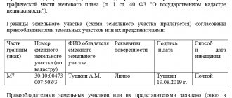
Only an examination with the results of which all interested parties agree can be recognized as legitimate and legal.
. To do this, an act of approval of boundaries must be attached to the boundary plan. It can be signed by:
- neighbor-owners;
- neighbors who are long-term tenants;
- legal representatives by power of attorney executed with the participation of a notary.
The notification procedure is prescribed in Article 39 of Federal Law-221. It is mandatory to notify neighbors in writing about planned geodetic work in the area. The minimum notice period is 7 days.
A meeting of owners and interested parties is held at the site on the day of the topographic survey. The work is carried out in the presence of meeting participants, after which the approval document is signed by the owners, neighbors, a representative of the local administration (for example, the board of SNT) and the engineer himself who carried out the work.
If you disagree with the work performed, objectors are required to:
- do not sign the act;
- Instead of a signature, attach a written statement of your claims to the survey.
All documentation is sent to Rosreestr, where objections and work performed are analyzed. Further, it is possible to challenge the boundary plan in court, or to declare the objections illegal.
Who can apply?
Consent to boundary work is provided by persons who own/use the adjacent plot on the following grounds (documented):
- ownership;
- lease agreements;
- rights of perpetual use;
- rights of lifelong inheritable ownership.
Accordingly, if during the procedure the interests of these categories of citizens were violated, they have the right to challenge its results independently or through a legal representative (subject to the execution of a notarized power of attorney, which will indicate his right to perform such actions).
Procedure for challenging
All property disputes are resolved in two ways:
- in a pre-trial manner;
- through the court.
Who can challenge
This right is granted to all persons interested in drawing up a boundary plan:
- owner;
- to the tenant (for long-term lease);
- neighbors whose plots adjoin the boundaries defined by the boundary plan;
- heirs of the above categories.
If one of them has not received written notice of the upcoming land survey, he can safely demand a revision of the technical plan by filing a lawsuit.
Where to do it
To challenge the result of land surveying or clarifying the boundaries of a site, you need to go to court with a claim to declare the boundary plan illegal.
The content of the claim is standard:
- a header indicating the judicial authority and all participants in the process with personal and contact information: plaintiff, defendant, third parties;
- document's name;
- circumstances of the case: on what basis the plot belongs to the plaintiff, what relation the defendant and the third party have to the conflict, and what is the essence of the claim. The reasons why the boundary plan should be invalidated must be clearly stated;
- requirements for the claim: to recognize the boundary plan as illegal, to appoint a new procedure for determining boundaries, and others;
- date, signature;
- list of attachments (copies of all documents mentioned in the claim).
The claim is filed with the territorial court at the location of the disputed territory - the area where land surveying was carried out incorrectly.
Documentation
Copies must be attached to the statement of claim:
- controversial technical plan of the area;
- plaintiff's identification documents;
- evidence that the document does not correspond to reality: this may be another boundary plan, data from the cadastre and other papers;
- contracts, certificates, extracts, emails, archives, etc. related to the conflict;
- information from witnesses;
- confirmation of payment of the court fee.
- A fully completed statement of claim consists of a claim and annexes. The office is provided with the number of sets according to the number of participants in the process.
Cost of the procedure
Since challenging land surveying refers to non-property disputes, the state duty for individuals is 300 rubles . Additional expenses - expenses for examination, other costs - can be recovered from the defendant.
Where to write a complaint?
It is important to note that the appeal process assumes that a citizen can only appeal to the judicial system. This option is resorted to only if the other options did not bring the desired result. To be able to negotiate peacefully with neighbors about where the borders will be, you will need to use the help of a cadastral engineer. This official is engaged in work of boundary value, while all owners put their signatures in the specified act. When the paper is clarified, it is transferred to the registration authority. If the parties cannot peacefully agree on their positions, then they will need to contact a judicial authority.
ATTENTION !!! An application is written to the district court. The location of the site in respect of which the dispute is underway is important.
It is the responsibility of the parties to justify their position. In this case, it is necessary to use the legislative framework. In addition, the parties have the opportunity to bring written evidence to the court hearing.
How does conflict resolution occur?
After setting the date of the meeting, agendas are sent to all participants: in the form of registered letters, telegrams or SMS notifications. At the first meeting, the plaintiff must bring the originals of all documents attached to the statement of claim.
The first meeting is usually introductory: the judge reads out the materials, gets acquainted with the positions of the parties, and attaches documents to the case. Defendants can present their accusations in the form of counterclaims, disagree with the plaintiff’s arguments and provide evidence of their case. On the same day, the judge determines the missing documents and orders an examination from the state geodetic organization.
Typically, in conflicts involving challenging a boundary plan, this procedure is mandatory. Therefore, lawyers recommend doing it in advance to save time and speed up getting a decision.
The outcome of all meetings depends on the arguments and persuasiveness of each party. The municipal cadastral engineer conducts his assessment (at the expense of the plaintiff or defendant), then the judge compares the result with the controversial boundary plan and makes a decision.