Cadastral passport of a land plot: what is it?
A cadastral passport of a land plot is a document that meets the official standard, which contains basic information about the plot. Issued at the local cadastre and cartography department when the legal owner takes possession of the land property, or at his request.
The document contains information from the State Real Estate Cadastre (GKN), reflecting all the parameters of the site at the current moment when the passport was received. The information entered corresponds to the standard established by the Federal Law on the State Property Committee No. 221-FZ, on the basis of which the passport entered into legal force on March 1, 2008. Therefore, the form of a cadastral passport of a land plot refers to the official documentation of the land.
Information about the memory is given in the form of a table, drawing and accompanying text . It is drawn up on three sheets, each of which is certified by the signature of an authorized official and the seal of the registering authority.
Let's talk about whether a cadastral passport is needed for a land plot.
Refusal to issue a cadastral extract
The reasons for refusal to issue this document are regulated by Law No. 218-FZ, which states that the registration authority may refuse to issue a certificate if it is impossible to eliminate a number of circumstances for which the issuance was suspended. There are quite a lot of such circumstances, and they are all spelled out in Art. 26 of Law No. 218-FZ.
Production may be suspended for the following reasons:
- lack of rights to a land plot;
- insufficient package or incorrectly filled in data in documents;
- invalidation of the transaction that was the basis for registration;
- the boundaries of the land plot submitted for registration cross the boundaries of another object or territorial zones, forest parks, municipalities;
- real estate objects were illegally built on the territory of the land plot;
- different categories of land are located on one site;
- violations identified as a result of the inspection or differences in the indication of the area of the object;
- expiration of the approved territory plan, which indicates information about the land plot.
The time frame for eliminating deficiencies varies; depending on the cause, the law sets a time period of one month.
As you can see, the procedure for drawing up a document has a lot of nuances, and if there is no land plot plan, you will not only have to spend a lot of time on geodetic work, land surveying and other services, but also pay a decent amount. To save time, money and nerves, it is recommended to contact specialized companies that professionally provide such services.
Why is it needed and what does it give?
First, let’s find out why we need a cadastral passport of a land plot. The document will be required in cases where it is necessary to establish the characteristics of a land plot :
- When conducting a property transaction of purchase and sale, exchange, donation or lease. This takes into account not only transactions with land property, but also with buildings erected on the site.
- When drawing up a will for the testator or heirs not specified in the will, but entering into inheritance by law.
- When the land plot is re-registered as the property of the copyright holder through privatization or redemption.
- In case of property disputes that require judicial consideration.
- Upon receipt of permission to erect a permanent structure on the site.
- When registering land or a capital structure erected on it as collateral or in case of real estate insurance.
- Using the land plot as authorized capital or filing a bankruptcy procedure. The passport is also used if the bankrupt transfers industrial and other objects belonging to him to creditors.
In these situations, the absence of a cadastral passport may cause the documentation to be recognized as incompetent, which will not allow a property transaction or other legal procedure to be carried out.
What does a cadastral passport of a land plot provide? Upon receipt and subsequent availability of a cadastral passport, the title owner will always be able to provide up-to-date information on the site without applying for an extract from Rosreestr, provided that the passport contains the required information.
For even more information about why you need a cadastral passport of a land plot, see the following video:
Extract from the Unified State Register and certificate
In 2014, obtaining a cadastral passport took place at the Cadastral Chamber; even earlier, this issue was dealt with by the BTI. Currently, as of January 1, 2021, the cadastral passport has been abolished; instead, an extract from the Unified State Register has appeared; this extract can be obtained from the State Registration Services (hereinafter referred to as Rosreestr) or from Multifunctional Centers (hereinafter referred to as MFC), it contains the same data , as the passport:
- exact area;
- location(address);
- purposes of use, as an example, agricultural purposes;
- category of land;
- price;
- ownership.
Essentially, this paper consists of several A4 sheets that contain the necessary information. You can see what it looks like (a current sample) on any information site.
- The first sheet is part B1. This sheet contains the data of the land plot. With this information, the owner will be able to evaluate the land without any difficulty before selling it or changing ownership.
- The second sheet is part B2. In graphic form, the sheet presents a plan of the land plot, on which the boundaries are clearly marked. The sheet is available if the property surveying procedure was carried out.
- The third sheet is part B3. Tells whether there are any encumbrances imposed on the land, and is filled in if there are any. Indicates: pledge, arrest, easement.
- The fourth sheet is part B4. The result of object surveying is certain dimensions of the land plot indicating boundaries and angles.
- The fifth sheet is part B5. Turning points within the boundaries of the earth, their clarification on paper.
An extract is a necessary document for performing many actions with a land plot. The owner should always have it, since the need for it often arises completely unexpectedly.
Registration of a certificate is a costly procedure, but necessary in the following cases:
- making transactions: donation, sale, purchase, exchange - wherever the owner changes;
- right of inheritance;
- in legal proceedings that concern land and its boundaries;
- land insurance;
- registration of lease;
- change of address, location;
- making changes to boundaries;
- use as collateral;
- in case of bankruptcy, liquidation of an organization;
- used to contribute a share to the authorized capital.
As you can see, a certificate may be needed whenever proof of ownership is required.
The document can be considered unlimited for one simple reason - not a single regulatory act specifies its validity period. Accordingly, until changes are made to the register, it will be considered valid. As soon as changes are made to the Unified State Register, its expiration date expires and it must be replaced with a new document with different data. It is necessary to make amendments or correct data in the following situations:
- boundaries change;
- the cost per square meter is adjusted. m.;
- the category of land changes (find out how to transfer land from one category to another);
- there is a change of ownership of the territory.
It is necessary to periodically monitor amendments to the characteristics of the land in order to change or restore the extract in time. This can be done on the official portal of Rosreestr by ordering an extract, which will contain all the necessary information, as well as the date and reasons for the changes made.
Validity period of a cadastral passport for a land plot
The validity period of the cadastral passport of the land plot is established as long as it contains up-to-date information.
But when conducting a property transaction or other legal procedure, it is required that it be received no later than 3 years in advance . This is due to the fact that after 3.5 - 5 years a land audit is carried out, which allows for changes in the cadastral value of the plot.
If you need a cost reduction, then you should read this article. It can also be challenged. To do this, you should learn the procedure described here.
Having found out how long a cadastral passport for a land plot is valid, we’ll talk about how to understand the information written in it.
Legal basis
Government Decree No. 921, issued in 2000, contains a clause according to which it is necessary to conduct a planned technical inventory of accounting objects at least every five years. The purpose of such a scheduled check is to identify changes that may have occurred since the initial inventory and reflect them in the relevant documents. True, this provision concerns primarily the technical passport, and not the cadastral passport, although many executors can equate these documents to each other. Does this mean that the validity period of a cadastral passport for an apartment or other property is five years?
There are older documents, in particular government decree No. 1301, issued in 1997, and order of the Ministry of Construction number 87 back in 1992. These documents do not contain such instructions, and initially there could be no talk of any “delay.” On its official website, Rostekhinventarizatsiya explains to users that there are several types of inventory, according to the already mentioned decree of 2000:
A separate issue is unscheduled inventory, since many are interested in the validity of the cadastral passport for sales and other real estate transactions.
How to read a document?
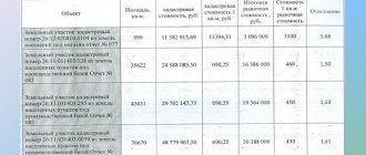
The information in the document is divided into 5 sections . Knowing the structure of the content, you can obtain the required information yourself. The first section (B1) contains general information :
- cadastral number;
- location;
- storage area;
- land category;
- permitted use;
- type of law;
- date of issue of the document, and date of registration of the land plot in Rosreestr.
To receive the entered data, you need to go to the appropriate section by selecting the information you are interested in. The information is given in a table; each column contains an information section with information about the site. For example, columns 7 and 14 contain information about the location of the memory:
- location address;
- coordinate system used;
- site boundaries.
Here, in columns 12 and 13, the most commonly used information on the cadastral value of land is given, taking into account the total area of the plot and the unit cost of one square meter in the massif.
Column 18 indicates the registration numbers previously assigned to the site - conditional, old or assigned before its reorganization.
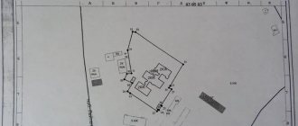
The second section (B2) provides a diagram of the memory configuration in the form of a solid line , reflecting the location of the boundaries in the surrounding context. The plan and its legend correspond to the scale indicated on the plan page. Sections B4 and B5 give the coordinates of the boundary boundaries of the site, and the turning points along which the boundaries were established.
The third section (B3) contains information about encumbrances with a pledge or easement . If there are no encumbrances, this information is not available.
What does a cadastral passport of a land plot look like?
Cadastral passport of a land plot: completed sample.
Methods for submitting a request for a document
The rules for obtaining it are clearly stipulated by federal legislation. Based on it, a person who has expressed a desire to formalize the right to own property must make a written request to local government authorities.
You must also provide:
- passport and your contact details;
- resolution on the provision of a site issued by the administration;
- extract from the business book;
- certificate of payment of state duty - receipt;
- boundary plan.
After receiving the materials, the employee responsible for these issues will issue a receipt. Authorized authorities will verify all information provided.
The materials may have some disadvantages. In such a turn of events, the procedure is suspended and the applicant is notified of this fact. All defects found are issued in the form of a notification. The process resumes only after they are eliminated. The procedure may take about 20 days.
How to make changes?
The basis for making changes is the fact of an official change in the previously entered information.
Any change entered into the fields of the passport requires replacing outdated information with up-to-date information..
So, how to make changes to the cadastral passport of a land plot? Changes are permitted at the initiative of the copyright holder or the registration authority . Rosreestr makes updates to cadastre records when conducting an audit.
In this case, the memory parameters may change and disrupt the identification of information entered in the passport. But the information content of the document changes only after the copyright holder submits an application to Rosreestr to replace outdated information.
When changes are made, the cadastral passport for the land plot is replaced with a new copy.
Our other materials will help you learn about:
- methods and approaches to cadastral land valuation;
- the procedure for removing a plot from cadastral registration.
What to do if you receive a refusal?
Oddly enough, they can refuse in different ways. There is a partial refusal (when consideration of your application is suspended), and there is a complete refusal.
Reasons for refusal include the following:
- If the applicant is not the owner of the land and is applying on a matter that is not an exception.
An exception means minor changes, for example a change in land category or a new address of a site, because In such cases, anyone can apply. - If the boundaries of the site have not been properly specified.
- The site plan does not meet the requirements (most often, this is due to the lack of proper certification).
- If the area of the plot becomes smaller by more than 1/10.
- If the size of the plot was changed without the land surveying procedure.
- The technical plan does not meet the requirements (most often the problem is incorrect certification).
Note! If the refusal is categorical, then you cannot do anything. If it is partial, then, provided that the shortcomings are corrected, the application will be approved. Possible shortcomings:
Possible shortcomings:
- incorrectly completed application;
- incomplete information about the object;
- the boundaries of the site cross prohibited boundaries (for example, neighbors);
- the position of several completely different objects coincides.
Step-by-step replacement instructions
Any significant changes in information require obtaining a new passport sample. For example:
- When reorganizing an allotment by merging several plots into one, or dividing one plot into two or more.
- When renaming a settlement, street or house numbering.
- In case of detection of overlapping boundaries and when adjusting their location by land surveying. For example, when reducing the area or increasing it due to cuttings.
- In other cases, changes in the coordinates of boundary boundaries or turning points.
- When changing the category of land or the intended purpose of the land plot.
- After an audit of the land mass, if the cadastral value of the land plot has been revalued.
- If the cadastral value has changed as a result of a court decision.
The algorithm for replacing a passport depends on the purpose of the procedure . The main basic steps are as follows:
- Contact your local cadastre and cartography office or MFC with an application.
You need to contact the registrar using the electronic queue number received at the institution’s terminal. Application for amendments to the cadastral passport of the land plot. - In the application, indicate information that is no longer relevant and formulate a request to replace it, indicating current information.
- If the site is not registered in the cadastral register, first contact a geodetic company and carry out land surveying.
- Pay a state fee of 200 rubles and attach a receipt to the application.
- Attach documentation to the application confirming the need to change the information. This could be a certificate with an independent expert’s opinion, a court decision, an administrative act to change the street name (house number) or other documentation.
- If the information has changed after the land audit, indicate this fact and, if necessary, confirm it with a cadastral extract.
- When registering for cadastral registration, indicate the fact of land surveying. The same applies to establishing boundaries with neighbors.
- After submitting the application and package of documents, expect the issuance of a new cadastral passport within 5 working days.
- When ready, receive the document for signature.
Only the owner of the plot can receive a cadastral passport in person, or a representative of his interests, acting on the basis of a notarized power of attorney.
When the owner of the storage unit changes
Since the personal data of the copyright holder is not indicated in the passport, changes are not required when changing the owner’s surname or after a property transaction . All entered information remains relevant until the specified land parameters change.
Why is it necessary to obtain a CN?
The presence of a cadastral number indicates the fact of its inclusion in cadastral records.
Accordingly, its absence indicates the opposite. This state of affairs may affect the conditions for concluding a property transaction. The buyer can significantly reduce the price offered for such a plot, as well as refuse to purchase it. There is a reason for this - no one wants to risk the money invested in the purchase of a storage device. At the same time, a person who owns a plot without securing ownership rights, which is officially certified only by Rosreestr, will not be able to substantiate a legal precedent for the emergence of the right.
A cadastral number should be assigned as soon as possible if it is discovered that it is missing. This will avoid problems associated with a weak legal basis for disposing of the site. Actions should be taken before a precedent arises for claims to the site by third parties or the administration.
Reasons for receiving
The basis can be considered the actual ownership of the site, which is motivated by one or another legal precedent. The exception is illegally seized municipal plots of land, the disposal of which has not received any official sanctions. But it is also permissible to take some forms of legalization of use in their direction.
Legal precedents giving the right of actual possession may be as follows:
- The allocation of land was carried out back in Soviet times to persons who had died by that time, having lost documentation and not having re-registered the allotment.
- The plot was sold before the Land Legislation of the Russian Federation came into force, without re-registration.
- Passed by inheritance as a result of an informal oral order of the deceased.
- The administration provided verbal permission to use the lands.
- These and similar precedents allow for the official registration of land, subject to the restoration of legal capacity.
In other cases, the official basis for assigning a cadastral number to a property is:
- title document for the allocation of land plots;
- certificate of inheritance;
- act of the administrative commission on permission to use;
- extract from the court decision.
With a civil passport and one of the legal grounds, citizens have the right to apply to Rosreestr.
How can I find out if I have a memory passport?
The main criterion for having a cadastral passport is the cadastral number . The assignment of a cadastral number means that the passport was issued or allows issuance at the request of the copyright holder.
If the owner of the land plot could not find this document in the package or is interested in the legal capacity of the acquired plot, the availability of the number can be found on the Rosreestr website at the address of the land location .
How to find out whether there is a cadastral passport for a land plot if this information is not found on the cadastral map for one reason or another? You can contact Rosreestr (through the MFC), requesting a certificate with information about the cadastral number of the plot of interest to the applicant.
Having received information that a passport was issued and a number was assigned to the plot, we can conclude that the land has been registered in the cadastral register and information has been entered into the register of rights holders of the land plot.
Having discussed the cadastral passport of the land plot, the validity period of the document and the procedure for making changes, you should find out what to do in the absence of documentation on the land plot or its damage.
How to get it from the MFC or Rosreestr
You can apply for:
- when contacting the MFC or Rosreestr in person;
- through the Rosreestr website;
- through the State Services website;
- through a representative for whom a power of attorney has been issued (must be certified by a notary);
- sending documents by mail.
The application must be in the established form, attached as an appendix :
- passport;
- a receipt certifying payment of the duty;
- document confirming ownership.
Registration takes 5 days .
If the land is not registered, the package of documents increases .
The application is updated:
- boundary plan;
- a certificate certifying the approval of the boundary plan;
- document confirming ownership;
- a certificate confirming the restrictions;
- a certificate defining the permitted use;
- a document confirming the existence of a share (in case of equity participation).
The paper form can be received in person (after 20 days) or through a representative by mail. When registering online, the statement is sent electronically.
Reasons or in what cases changes need to be made
A variety of facts can serve as grounds for making changes (for example, a change of address). Unfortunately, not a single regulatory legal act clearly lists these facts and grounds, therefore, in order to list the grounds in as much detail as possible, you will have to resort to the practice of cadastral chambers.
So, the first case requiring replacement of the cadastral passport is a change of owner.
Of course, it would not be too smart to throw the previous passport in the trash after each change of ownership and start drawing up a new one. This will take a lot of time. Therefore, the passport is subject to change. Information about its new owners is entered into it and the passport is sent to you within a very short period of time.
This method will save not only your time, but also money.
Another reason for changing your passport is a change in your real estate. Let's take a plot of land as an example. It marks all buildings that are important for the cadastral chamber and Rosreestr, and also marks the boundaries.
And now, a situation arises when you start building another building. After construction is completed, you need to invite a cadastral engineer to take measurements of the new building and mark it on the plan accordingly.
The last and most common reason for changing the cadastral passport is its damage.
Some cadastral passports deteriorate from age and simply need to be replaced so that later you don’t have to restore a pile of yellowed and faded paper.
Someone accidentally damages the cadastral passport by spilling water on it and causing other, not the most pleasant consequences.
Such a document will need to be restored, but you should not put it off for a long time. A damaged document can quickly lose all its functions and properties due to paper fading, softening, and so on, and you will not be able to change your passport - you will have to spend a lot of your time and money on having engineers re-take measurements and draw up a cadastral passport. Inclusion in the state real estate cadastre is a complex and expensive process.
Procedure and rules for filling out
All information entered into the cadastral passport must fully comply with the data contained in the state real estate cadastre.
The only exception is the content of the “special notes” column, information in which may not be included in the cadastre.
The owner can receive it from the territorial division of Rosreestr or the MFC, after submitting an official application to one of these bodies. This can be done either through a personal visit or via the Internet, on the official website of one of these government services.
So, a cadastral passport is an important document for every owner of a land plot, since it is required for most transactions in relation to this property.
It is drawn up in accordance with the form established by law and contains all the most important characteristics of the site. The document has no statute of limitations, but it must be replaced if any important data changes.