If disputes arise regarding the established boundaries of a land plot, such issues are resolved taking into account the governing legislation .
This includes the Land and Civil Code of the Russian Federation and regulations that determine the procedure for establishing boundaries.
The method for resolving a dispute regarding the boundaries of a land plot is determined based on the reason for the appeal.
Also, the choice of dispute resolution method depends on the availability of evidence on the basis of which legal proceedings can be initiated.
The legislative framework
Let's consider the basic laws and regulations that can be relied upon if the need arises to resolve the issue regarding established boundaries or problems in determining the boundaries of plots.
Article 30, part 1 of the Code of Civil Procedure of the Russian Federation
In accordance with the provisions of Art. 30, Part 1 of the Code of Civil Procedure of the Russian Federation, it is determined that the site is an object of ownership and if any issues arise that affect the interests of the direct owner or a person who owns it under the right of use, it is possible to appeal to the court.
The body to which the statement of claim must be sent for consideration of the controversial issue is determined by the location of the object .
Article 6, paragraph 3 of the Land Code of the Russian Federation
Based on the Land Code of the Russian Federation (Article 6, paragraph 3), the concept of a plot is defined, which acts as an immovable thing, representing a part of the surface of the earth and having such characteristics that define it as an individual thing.
In certain situations, it is possible to create artificial plots , over which ownership rights may also arise.
Article 7, paragraph 1 of the Land Code of the Russian Federation
Based on Article 7 of the Land Code of the Russian Federation, categories of land are determined to which, depending on their type or type, different rules for the emergence of property rights and the procedure for resolving disputes regarding established boundaries may be applied.
In particular, subsoil may relate to lands for agricultural purposes, settlements, industry, energy, specially protected areas and objects, forest and water resources, etc.
Article 39, part 1-3 of the Land Code of the Russian Federation
Parts 1-3 of Article 39 of the Land Code of the Russian Federation consider the possibility of the emergence of rights to those plots that are provided by their total mass, initially in the use of the state or municipality.
Thus, in particular, grounds are identified in the form of a decision of an authorized body, the conclusion of a purchase and sale agreement, a lease or an agreement for free use.
The procedure and organization for the transfer of ownership or use rights to legal entities and individuals is separately indicated.
Responsibility and fines for trespassing
Anyone who appropriates someone else's property faces liability for an administrative offense. The fine is determined based on the cadastral value of the land and amounts to 1-1.5% of the amount. The amount of the penalty will be from 5 to 100 thousand rubles if the violator is an individual. A person will have to return someone else's land and demolish the buildings erected on the territory. The fine for a legal entity will be 2-3% of the cadastral value or 100-200 thousand rubles.
ATTENTION! The size of fines is constantly changing; in the regions, tariffs are set by executive authorities.
Who sets the boundaries of lands adjacent to neighbors
The establishment of borders adjacent to neighbors is carried out by contacting a state or commercial organization that has the authority to determine the boundaries of allocated or only allocated land plots.
The direct work is performed by an engineer from a geodetic company or municipal cadastre department , while the owner can independently determine which commercial organization to contact.
The determination of boundaries on a free basis is carried out as part of complex cadastral works planned until 2021.
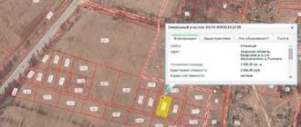
In the process of determining the boundaries of a plot, the engineer first familiarizes himself with the documentation provided by the owner or holder,, if necessary, sends inquiries about the location of the plots and subsequently travels to the location of the plot.
A visit to the site is carried out in order
to establish turning points , between which lines will be drawn, acting as boundaries.
During the process of establishing boundaries, errors may be made, which will cause incorrect data to be entered into the register.
In addition, in the process of using the site, other problems and issues may arise that provoke the emergence of disputes regarding existing boundaries.
Possible reasons for disagreement
Disputes regarding existing boundaries of land plots can arise for a number of reasons. Depending on this reason the method of solving the problem , the possibility of revising the established boundaries, as well as the need to eliminate violations and bring to justice, if such action is provided, are determined.
Non-compliance with regulations
Separately, violations of norms that arise in the process of direct exploitation of land , these include:
- Violation of existing fire safety . Such points, as a rule, apply to objects erected for any purpose on a site, during the construction of which the current rules were not taken into account;
- Violation of building codes . When constructing objects on the site, it is necessary to take into account the currently valid rules and regulations regarding the parameters of the real estate. If they are violated, the boundaries of the plots may be partially affected, as a result of which there is a need to revise or clarify the boundaries;
- Violation of sanitary and hygienic standards . Such norms and rules may be ignored in the process of conducting communications or supplying certain resources to an object being built on the site.
Location objection
One of the most common moments of border violation is the seizure of neighboring land.
This action means that neighbors arbitrarily move the established boundaries and thus illegally use someone else’s territory.
In such a situation, on the basis of the provisions of Article 60 of the Land Code of the Russian Federation, a claim is filed and, in the course of the proceedings, the following facts are included as evidence of violation of property rights:
- The location of the border and the location before the seizure of foreign territory;
- Description of the essence of self-capture - determination of the area and related factors;
- The need to eliminate unauthorized seizure.
It is in the interests of land owners whose rights have been violated, upon discovering the fact of squatting, to immediately contact a notary to arrange a “notarial inspection of evidence” while the old boundary lines are still visible from the traces of the fence and other dividing elements.
Impossibility of mutual agreement
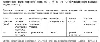
In the process of establishing boundaries, there must be a procedure for their approval.
It consists of notifying all interested parties about the place and date of the general meeting , at which the neighbors of the site, whose boundaries are being determined, get acquainted with the place where they will directly pass and, if there are no complaints, sign a special act as a sign of consent.
In certain cases, neighbors may have claims that cannot be resolved on the spot; in such a situation, the owner of the plot can initiate legal proceedings aimed at eliminating the problem of the impossibility of mutual agreement on boundaries and resolving a dispute between neighbors.
Construction on “free” land
The construction of real estate on so-called “free” land in almost all cases entails the need to resolve a dispute regarding the boundaries of the territory, which may be the property of a legal entity or individual.
First of all, the issue of the legality of such a building and the possibility of its further existence and operation is resolved, and subsequently the dispute over the boundaries of property is resolved.
Contradictions in documents
From time to time, in the process of accessing documents containing information regarding land plots, it turns out that they contain data that does not correspond to reality.
If it is necessary to change the information contained in such documents, the interested person must contact Rosreestr , and in case of refusal to revise and clarify the data, contact the court located at the location of the allotment.
Registry errors
One of the reasons for the emergence of disputes regarding the location of a site may be an error made by a cadastral engineer , due to which disagreements arise.
The essence of such an error may lie in incorrectly defined turning points, an error when setting out boundaries in nature, or incorrectly entered data on established boundary points.
The procedure for resolving such disputes consists in identifying the error itself , collecting the necessary documentation confirming the fact of inaccuracy and applying to initiate a procedure for revising the data on the boundary of the site or carrying out work to eliminate incorrect data and enter valid data into the documentation.
Documentation
To install a boundary post and avoid a dispute over the boundary, you need:
- documents on ownership and right to use land;
- passport of the person who expressed a desire to carry out land surveying;
- application (submitted to a company licensed to conduct geodetic measurements);
- cadastral passport (if you don’t have it on hand, an extract from this document can be a replacement);
- boundary plan;
- a certificate confirming the presence or absence of public communications in the intervening territory (water supply, gas pipe, telephone cable may cause a dispute).
The specific list of papers depends on the region, the nature of the boundary dispute, and the economic purpose of the plot to be demarcated.
Note! In order not to return to the controversial issue of boundaries in the future, special boundary signs (poles) are installed between nearby areas. It is illegal to independently move boundary markers in any direction. If this happens, then the land surveying procedure will have to be repeated (moving the boundary post is a reason for a dispute in court on the issue of land surveying).
Problem resolution algorithm
The algorithm for resolving disputes that arise regarding the boundaries of land plots consists of initially contacting a cadastral engineer, initiating the procedure for re-coordination of boundaries, preparing an application to the court, participating in a court hearing and making changes to official documents.
Contacting an engineer to draw up a report
The procedure for approving the boundaries of the plot of interest should be carried out exclusively through the participation of a cadastral engineer in such an action .
The owner of the site or another interested party contacts a geodetic company to carry out such a procedure, and a separately authorized engineer becomes responsible for drawing up a boundary approval act.
Renegotiation
In the event of a change in the existing boundaries of the allotment, even in situations where the existing errors have been corrected, it is necessary to initiate a re-coordination of the passing boundaries.
The scheme for carrying out such actions is standard - notifying all interested parties, holding a meeting and drawing up an official document .
Preparing a statement of claim to challenge
If it is necessary to go to court to protect their interests, the owner or user of the site must correctly draw up a statement of claim, according to the sample, which includes the following points :
- Name of the organization to which the statement of claim is sent;
- Indication of the plaintiff - the one who is filing the claim;
- Reflection of the essence of the problem - violation of property rights;
- A link to documentary evidence that confirms the need to resolve the dispute and, in fact, the very presence of inaccuracies in the documents;
- A reference to regulations and laws, according to which it is possible to resolve the problem in favor of the plaintiff.
In addition to the statement of claim itself, in order to challenge it, you will need to attach to it a list of necessary documentation :
- A copy of the completed application;
- Power of attorney (if the application is not submitted by the owner or user of the site);
- Receipt for payment of the state fee for filing a claim;
- Documents on the right of ownership or use of the site;
- Applicant's passport;
- Documents confirming an attempt to resolve the dispute out of court.
Court hearing
After filing a claim and providing the necessary documentation, an open meeting is scheduled , in which both the plaintiff who filed the application and the defendant in the existing land dispute can participate.
The submitted papers are reviewed, the testimony of all parties and additional invited witnesses in the case is heard.
After a debate between the parties, the court makes a decision, which, if the plaintiff or defendant disagrees with it, can be appealed .
Court decision and appeal to the rights registration authority for redistribution
After the applicant receives a court decision, according to which it is possible to revise incorrectly established boundaries or areas violated during operation, he has the opportunity to contact Rosreestr to make changes to the registration documents .
If the interested party is repeatedly denied, he has the opportunity to file a second claim again, although in judicial practice this happens quite rarely.
Legal regulation
Federal Law No. 221-FZ of July 24, 2007 “On Cadastral Activities” is considered fundamental in resolving such conflicts. It states that the location of the borders must be agreed upon with interested parties, who are considered neighbors.
Thus, Article 40 of this legal act directly establishes that the results of the procedure are considered to be the signing of the act by all persons interested in it.
That is, the law directly states that land surveying includes the process of coordinating neighboring boundaries. If it fails, the situation will have to be resolved in court.
During the judicial process, it is worthwhile to be guided by the norms of the Civil Procedure Code, as well as materials from judicial practice, which will help to better understand the contradictions that have arisen and determine the approximate prospects of the case.
Link to document: “On cadastral activities”
Features of land management expertise
A land management examination is appointed when eliminating errors or inaccuracies in the documents compiled on land plots and, in particular, when establishing the actual boundaries of the allotment .
During the examination, preparatory work is carried out, measurements of the allotment are carried out, boundaries are drawn out in kind, a site plan is developed, and then a report on the work performed is drawn up.
The drawn up examination report includes a conclusion about what actions were carried out, as well as information about the possibility of carrying out certain actions with the allotment.
What are the dangers of crossing site boundaries?
The main result of detecting the intersection of land boundaries is the suspension of cadastral registration. This requirement is contained in Article 26 No. 218-FZ. This means it is impossible to register transactions with land and real estate located on it.
Moreover, identifying the problem under consideration also entails the theoretical possibility of canceling previously concluded transactions. Even in case of successful state registration. Therefore, one should not be surprised at the relevance of the service to eliminate the crossing of boundaries of land plots, which is provided by specialized organizations. A special feature of the event is the need for a thorough knowledge of cadastral affairs and the nuances of land management law.
Fixing a registry error
If registration errors are made, which periodically occur when entering data on land plots, experts recommend sending requests to the territorial department of Rosreestr to correct the technical inaccuracy.
Employees of such a government body can correct the error on their own, but in practice most often they have to go to court , based on whose decision the necessary changes are made.
What to do after a land survey trial
An experienced lawyer on land issues recommends monitoring the execution of the court decision, and not limiting oneself to just the “paper version”. If the transfer of a disputed boundary, which was incorrectly determined due to violations during land surveying, is awarded, it is necessary to bring the matter to its logical conclusion and rearrange (install) the fence. In the future, this will relieve neighbors from mutual claims regarding the location of buildings, planting of trees and shrubs.
But you shouldn’t “go too far” either. In particular, you should not install fences that violate established regulations and standards. Otherwise, a situation will arise when you will have to appear in court not as a plaintiff, but as a defendant.
Due to frequent updates to legislation and the legal uniqueness of each situation, we recommend obtaining a free telephone consultation with a lawyer. You can ask your question by calling the hotline number 8 (800) 555-40-36 or write it in the form below.