Establishing the boundaries of a land plot is often associated with controversial issues.
In particular, such moments may arise when the cadastral engineer makes mistakes, uses outdated equipment or inaccurate data .
As a result, the documents issued to the owner of the plot contain inaccurate information and data.
Both these and other cases that lead to cadastral errors during land surveying require contacting Rosreestr in order to make the necessary adjustments and bring the documentary data into line with how the border actually runs.
In the event that the application of the owner of the site is made after 30 days from the date of approval of the boundary plan , in most cases, changes can be made through a court decision, for which it is necessary to send a corresponding statement of claim, attaching the required package of documentation.
Documents that are the results of the procedure
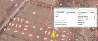
In the process of establishing the boundaries of a land plot, the cadastral engineer draws up a boundary file, and the main document included in it is the boundary plan.
Such a plan consists of graphic and text parts and contains a diagram of the location of the site indicating the coordinates of turning points, lines drawn between them, which are boundaries defining the boundaries of the property.
Its text part contains a description of the land plot, containing its main characteristics that are important for determining the cadastral value, the possibility of erecting buildings or structures, cultivating for planting crops and other actions that may take place during the operation of the site.
Based on the drawn up boundary plan, the owner of the plot can apply to register the plot, obtain a cadastral passport, ownership rights, and also make any transactions of a civil law nature that are not prohibited by law .
Causes of border disputes
A land plot for individual use can be called a part of land that arises as a result of dividing a large plot into small ones with the boundaries recorded in the register (primary surveying, carried out by the municipality or the owner). It must be registered as property and registered in the cadastral register, assigned to a specific land user.
A site - especially if it is old, has existed for a long time and has even been inherited - during its operation it can change its boundaries: an unsuccessfully installed fence, earthworks, construction, etc. Boundaries can also be shifted intentionally.
Clarification of the boundaries of a land plot can initiate:
- owner;
- tenant under a long-term contract (more than 5 years);
- judge when resolving a dispute.
Typically this procedure is carried out in connection with:
- with purchase and sale or exchange transactions;
- with dividing the plot into smaller ones or allocating parts for the new owner;
- with the combination of the plot with the neighboring plot.
A separate point is the resolution of conflicts with neighbors. Typically, the question of legitimate land surveying arises if:
- a neighbor put up a permanent fence, occupying someone else's territory;
- he built a building that took over the area of the neighboring plot;
- the owner arbitrarily appropriated part of the common territory: he seized a section of the road, the adjacent territory, in a word, he prohibited access to public land.
If, when trying to point out the discrepancy between the actual boundaries and the legal ones, a neighbor provides a dubious boundary plan, it is worth trying to challenge it in court and restore the integrity of the boundaries of your property.
Reasons for invalidating results
The law defines the moments and conditions under which the owner of the plot, another person or organization whose rights were affected in the process of land surveying, can count on the admissibility of challenging the results of establishing boundaries.
Thus, such conditions include the following:
- Carrying out land surveying without a boundary approval document signed by all interested parties. The absence of signatures is allowed only if such persons do not appear after the owner of the site has complied with the required notification procedure and there are no written statements from neighbors about disagreement with the boundaries passing in this way;
- Allowance of violations during the execution of work by an engineer. This may be the absence of an operation to go to the site to draw the boundaries in nature, ignoring documentary data on the basis of which the boundary will be drawn in a different way, etc.;
- The emergence of new documentary data or testimony that changes the course of the laid boundary;
- Detection of an error in the provided data . This may be the intersection of the boundaries of adjacent plots, the imposition of one plot on another, the assignment of land to a completely different territory, any other inaccuracies that will occur in the graphic or text part;
- The acquisition of land and its transfer of ownership as a result of squatting of the territory. Such situations occur quite rarely, but can still occur as a result of an inaccurate analysis of the provided documentation by a cadastral engineer or the submission of unreliable data by the customer.
How to cancel results through court
It is possible to cancel the survey results by performing the following steps :
- Contacting the engineer who drew up the existing boundary plan and determined the coordinates of the passing boundaries of the site;
- Collection of documents that may indicate the presence of errors in the drawn up boundary plan;
- Drawing up a statement that reflects the requirement to eliminate the existing error in the boundary plan;
- Providing a package of documentation, a receipt confirming payment of the state fee and the application itself to the cadastral chamber;
- Receive a response within 15 days from the date of application. In most cases, the cadastral chamber refuses to satisfy the person’s request, citing the presence of an existing boundary plan;
- Submitting an appeal to the court. This is done to make it possible to force changes to the drawn up plan based on a court decision;
- Drawing up a claim, providing a completed application with a package of documentation, including confirmation of an attempt at pre-trial settlement along with a receipt for payment of the state fee.
Who has the right to challenge the results?
The possibility of filing appeals to the court to challenge the existing survey results can only take place if the person or organization acting as the plaintiff has grounds.
the following persons have the right to challenge established boundaries in court :
- Persons using the plot or adjacent plots on the basis of a concluded lease agreement;
- Owners of plots who have documentary evidence of ownership of a certain plot of land;
- Persons who own a plot of land with the right to use it indefinitely;
- Persons who own a plot of land on the basis of lifelong inheritable ownership.
Documentation
An appeal to the court in order to be able to challenge the results of land surveying through the court must be accompanied by the preparation and provision of the necessary documentation package in such cases.
The list of documents may differ slightly depending on the specifics of the case under consideration, but it has many common points, among which are :
- A document confirming the right to go to court to challenge the results of establishing boundaries (certificate of ownership, lease agreement, etc.);
- A document confirming the ownership of the person who is filing the claim in court;
- The statement of claim itself, which contains the essence of the issue regarding the established boundaries of the site;
- Land survey plan containing errors;
- A new boundary plan containing the correct information that will need to be entered into the state register.
Contents of the statement of claim
The submitted statement of claim must contain the following information :
- Full name of the applicant, his basic data, information about the site about which there is a dispute;
- Data from the defendant who has a different opinion regarding the boundaries;
- Indication of the essence of the problem - the existing errors in the drawn up boundary plan that need to be eliminated are outlined. In the main part, it is recommended to indicate that the presence of an error violates the existing property right and at the same time does not allow the site to be used to its fullest;
- A reference to laws and other regulations on the basis of which it is possible for the applicant to appeal and declare the boundary plan invalid and requiring amendments;
- Date of completion and signature of the plaintiff.
Hearings
During the trial, the court first considers the submitted documents.
Then it determines whether there are grounds to initiate proceedings.
After this, if all the documents provided do not raise doubts, no additional evidence is required and no challenge is made, a court hearing or public hearing is scheduled.
During the meeting itself, the arguments of both the plaintiff and the defendant are considered , and the overall outcome of the case will largely depend on how complete the list of data set out in the statement of claim is.
When considering an application, testimony of witnesses who are directly related to the case may be heard if the evidence base in the form of documents is insufficient.
If there are counterclaims, they are also accepted for consideration and, if necessary, an examination is scheduled , which is ordered from a geodetic company.
Based on the conclusions of expert surveyors, one can judge how correctly the land surveying was carried out and whether the drawn up plan actually contains erroneous data.
Solution
If there is sufficient evidence, the court may satisfy the application submitted by the plaintiff with a request to recognize the survey results as invalid.
In this case, it becomes possible to re-apply to Rosreestr , where, on the basis of the court decision provided, changes will be made to the data on the land plot, provided that a correctly drawn up boundary plan is attached.
Participation of neighboring owners in the land surveying procedure
Only an examination with the results of which all interested parties agree can be recognized as legitimate and legal.
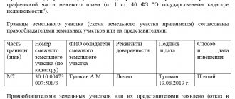
. To do this, an act of approval of boundaries must be attached to the boundary plan. It can be signed by:
- neighbor-owners;
- neighbors who are long-term tenants;
- legal representatives by power of attorney executed with the participation of a notary.
The notification procedure is prescribed in Article 39 of Federal Law-221. It is mandatory to notify neighbors in writing about planned geodetic work in the area. The minimum notice period is 7 days.
A meeting of owners and interested parties is held at the site on the day of the topographic survey. The work is carried out in the presence of meeting participants, after which the approval document is signed by the owners, neighbors, a representative of the local administration (for example, the board of SNT) and the engineer himself who carried out the work.
If you disagree with the work performed, objectors are required to:
- do not sign the act;
- Instead of a signature, attach a written statement of your claims to the survey.
All documentation is sent to Rosreestr, where objections and work performed are analyzed. Further, it is possible to challenge the boundary plan in court, or to declare the objections illegal.
Arbitrage practice
During legal proceedings regarding the invalidation of the results of a land survey, there are a large number of cases of judicial practice that had an excellent outcome depending on the completeness of the evidence provided and the testimony heard.
In particular, there are cases of refusal to consider a case, initiate proceedings and invalidate the survey results.
There are cases when the plaintiff’s demands were not satisfied, since upon consideration of the circumstances it was proven that the drawn up plan contained reliable information .
By dispute
The practice of challenging the results of land surveying has the following options for making court decisions :
- Refusal to consider the case due to the fact that the person who sent the application is not the owner or user of the site, and therefore his direct rights were not affected or infringed;
- Refusal to initiate proceedings due to insufficient documents provided, that is, the plaintiff did not provide compelling arguments that the boundary plan contains errors;
- Refusal to consider the submitted application due to the lack of an attempt at pre-trial settlement - an appeal to Rosreestr to make changes to the boundary plan due to errors in the one already drawn up.
Upon recognition of the results as invalid
As a result of consideration of cases to invalidate survey results, in most cases the decision is made in favor of the plaintiff filing an application in the following situations :
- If there is unauthorized occupation of land plots by neighbors, as a result of which the boundaries of the property have been distorted;
- If significant errors were made during the formation of the land allotment and determination of the area of the plot, after which inaccurate data were entered into the state register;
- If, as a result of land surveying, the act of approval of the established boundaries was not signed by all interested parties;
- If the mandatory procedure for notifying owners and users of adjacent areas about the upcoming procedure for drawing out boundaries and their approval has not been followed;
- If reliable data is provided indicating the presence of errors in the boundary plan of the site.