The legal capacity of land owners depends on the results of boundary surveying with land plots located in the neighborhood .
It is also very important for owners of neighboring plots to clearly define and secure boundaries.
Therefore, their presence during land surveying and their expression of their opinions are an important condition for the correct and legal conduct of the land surveying procedure.
Land surveying methods
There are the following methods of land surveying:
Cartographic (paper determination of the boundaries of the site, i.e. using maps and plans available in the land management service).
Instrumental (carried out directly on the territory where the site is located).
The instrumental method allows you to obtain accurate figures for the land area owned by one owner, since specialists, when making calculations, use data obtained thanks to:
- satellite geodetic installations,
- electronic tachometers,
- theodolites,
- rangefinders,
- photogrammetric mechanisms,
- light rangefinders,
- digitizers, other devices and instruments.
Procedure
The demarcation of the garden plot is carried out in stages in the following order :
- collection of documentation;
- selection of a cadastral engineer;
- conclusion of an agreement;
- coordination with neighbors;
- carrying out geodetic work and determining boundaries;
- formation of land surveying.
The contract may stipulate additional cadastral services.
Coordination with neighbors
Before defining the boundaries of a garden plot, by law they must be agreed upon with interested parties .
They are neighbors of adjacent plots. It is necessary to notify them of the arrival of the cadastral engineer and establish a common boundary through negotiations.
A notice is sent to absent neighbors .
The address can be found in the SNT Board or the cadastral chamber.
If there is no information about neighbors, and they do not appear on the site, then approval is indicated through publication in a local newspaper . The information about the notification is recorded by the cadastral engineer. After this, the boundaries are considered consistent even if there are no neighbors.
The approval is drawn up in the form of an act on the reverse side of the land survey plan. All owners of neighboring plots put their signature on the boundary there. Ownership or possession is confirmed by reference to the document number.
Carrying out without the consent of neighbors
Without the consent of neighbors, boundaries will be determined only if the neighbors have not expressed a desire to participate in the coordination .
In order to avoid claims, the notice must be drawn up in accordance with all the rules. It must be delivered personally to the address at least 30 days in advance . Or by mail with notification also one month before the survey.
Neighbors have 15 days to refuse, indicating a valid reason for their absence.
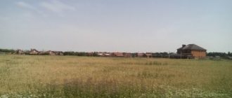
Determining the boundaries of the plot and its area
The boundaries of the site are determined using special instruments. Their error can be as little as 1 cm.
Boundaries are fixed with boundary signs and transferred to the map. The area is calculated using one of the formulas.
Drawing up a boundary plan
A boundary plan is a document that has a clear structure and consistency of presentation. It contains all the documents that were involved in the survey. It has text and graphic parts. The number of pages depends on the amount of materials collected.
The boundary plan has:
- title page;
- information about the site;
- information about the customer of the work;
- information about the cadastral engineer;
- act of approval;
- site drawing.
The boundary plan can be in paper or electronic form . The electronic version must contain the electronic signature of the cadastral engineer.
Rules for conducting boundary surveys
The rest of the article describes how land surveying occurs (is carried out).
Procedure:
- An application is written about the need to carry out land surveying (submitted along with a package of title documents to the organization carrying out engineering and geodetic work);
- The specialist goes to the site, having previously collected data on the coordinates of boundary markers;
- Geodetic survey is carried out;
- The collected data is analyzed, calculations are made, and a boundary plan is written;
- The completed document is registered in Rosreestr .
What papers will the site owner need:
- Sales contract/inheritance certificate;
- A certificate of the decision of the administration that managed affairs in the territory with the site of interest to transfer it for use to a specific person;
- Extract from the land registration register;
- Document on the boundary dispute (if any).
In addition to the documents provided by the owner of the site from the personal archive, it is necessary to collect a separate package of documents , which should include:
- Land development project;
- Papers informing about land inventory;
- Drawing of possible boundaries;
- Cadastral map (if available);
- Topographic map;
- Information about existing official boundary signs;
- Photo plan of the area of interest;
- Information about the GGS and OMS (the state geodetic network (GNS) and the reference boundary network (OMS) - reference boundary marks (OMZ)).
You can collect the second package of papers yourself or with the help of a specialist from the same organization where you will apply with an application for the need to carry out land surveying.
Step-by-step instructions for surveying
Step 1 - prepare documents for the land plot
If a land plot is being formed for the first time, then to begin land surveying you will need a diagram of the location of the plot on the cadastral plan of the territory and a resolution of the head of the district administration on the allocation of the land plot.
If you already own a plot of land, then you will only need an extract from the Unified State Register of Real Estate, in which you are indicated as the owner.
Please note that in Rosreestr an extract from the Unified State Register costs 350 rubles (700 rubles for legal entities). If you want to get information cheaper, I recommend ordering a certificate through Quick Documents - this way you will receive a document for only 250 rubles. The order is completed within a day, the official data is from the Unified State Register of Russian Registers of Rosreestr.
Certificate from the Unified State Register of Real Estate, which I recently ordered through Quick Documents
Step 2 - find a competent cadastral engineer
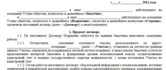
Find a cadastral engineer in your city, explain the situation to him and agree on the cost of services, terms and form of payment. Then sign and pay for the agreement for the provision of agreed services.
Entrust land surveying only to qualified specialists with the function of cadastral engineer. However, we will return to the question of how to find the best cadastral engineer in your city.
Step 3 - receive documents and sign the work completion certificate
As a rule, a cadastral engineer performs all work related to land surveying on a turnkey basis. All you have to do is get a cadastral passport, boundary and technical plan (if needed) from him.
A boundary plan is needed to register one or more land plots for cadastral registration, a technical plan is needed to register a building, structure or unfinished construction site. The land survey file is provided in electronic form (on a CD), if you need it on paper (for example, for court), they will not refuse you.
At the end, check the data in the documents and sign the certificate of completion of work in 2 copies. Keep one of the originals of the act for yourself.
Step 4 - verify the survey results
It takes 10-14 days from the date the service agreement is signed until the finished documents are issued. After another 5-10 days, the new boundaries and data on the land plot will begin to be displayed on the public cadastral map of RosReestr. To clearly see the survey results, enter the cadastral number of the plot here: pkk5.rosreestr.ru.
At this point, land surveying as a process can be considered completed.
How to do it?
Make copies of the documents on hand (you may have to have them certified by a notary).
Having determined which of the organizations that carry out land surveying is trustworthy and acceptable in terms of prices, you hire a specialist (to create favorable conditions for faster work, agree on phased payment - part immediately, part after drawing up the plan).
A hired specialist studies the available documentation and then goes to the area to determine the safety of official reference points.
The contact details of the neighbors in the area are sought, after which they are sent notices about the need to arrive on a certain date at their site to present (if required) claims on the boundaries.
If it is impossible to find contacts, notification is carried out with the involvement of local media (non-arrival of neighbors is not an obstacle to the land surveying procedure).
Taking into account the reference boundary signs, the boundaries of the site are fixed and its area is determined. The new markings are agreed upon with the neighbors .
Draw up a boundary plan, which should include:
- Data on the boundaries of the site and adjacent neighboring plots;
- Land area;
- Information about the methodology for determining boundaries;
- Data on changes in the size of the plot and adjacent plots;
- Information about easements (list of encumbrances on the site);
- Information that the new boundaries have been agreed upon with the owners of neighboring plots.
You can see how land surveying is done in the video below:
Compound
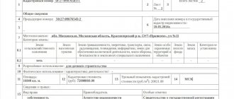
Let's consider the structure of the boundary plan.
The grafical part
It reproduces data from the cadastral plan of the desired territory: the location of the boundaries forming the land plot is indicated, these boundaries and access to the land are specified (pedestrian or motor roads from public areas). Using the graphical part, you can get an idea of what the boundary plan of the land plot looks like.
Text part
This section of the document specifies the information necessary to enter the land into the state real estate cadastre. The scope of this information is established by the regulatory authorities of cadastral relations and the Federal Law “On the State Real Estate Cadastre”.
Who does (conducts)?
Who is doing the land surveying?
Cadastral engineer who has a certificate of the right to carry out land surveying.
Independent surveying
Unauthorized determination of plot boundaries has no legal force .
Who should attend?
- The owner of the allotment;
- Hired specialist;
- Owners of plots adjacent to your site.
If the neighbor did not appear for the survey, the survey plan will indicate that, despite the invitation to appear on the site on a certain day, the owner of the neighboring plot was not present during the preliminary survey procedure.
The absence of a neighbor/s on the day of land surveying lengthens the process of generating a land survey certificate.
Neighbors who did not show up at the first notice should be notified again , indicating in the document the date when the survey will be carried out again.
Failure to appear upon repeated invitation and the absence of a written complaint allows us to assume (by law) that the neighbors by default agree with the results of the land survey.
However, later, if a neighbor considers that the land survey was carried out incorrectly, he can file a claim in court.
Contents of the boundary plan
There is a boundary plan form developed by the Ministry of Economic Development and used by cadastral engineers. It was approved by Order No. 921 in January 2021. It began to be applied in 2017, when Law No. 218-FZ came into force. It is divided into several parts:
- Title page;
- Structural part about the cadastral work carried out;
- Primary data on real estate,
- Data on measurements and calculations made by the engineer;
- Schematic representation of the allotment;
- Final drawing.
The boundary plan can be divided into two parts:
- Text or informational
- Tabular.
They will contain all the information collected by the cadastral engineer:
- Data about the site itself: address, land category, cadastral number, purpose, etc.;
- Primary data on the location, boundaries, area and features of the site;
- List of work carried out as part of land surveying, data on calculations and measurements;
- Information about bordering areas and access routes;
- Reasons for the formation of the site;
- Information about parts of the plot not included in the cadastre;
- Data on the coordination of boundaries between neighbors.
The tabular section reflects:
- Scheme of geodetic constructions located on the territory of the allotment;
- Image on the diagram of border areas;
- Outline data of nodal points;
- A diagram of the site itself and the structures located on it.
Thus, all boundary plans are for the most part similar and convenient to use.
How to register correctly?
Stages of registration of land surveying:
- Collection of documentation;
- Hiring a specialist;
- Distribution of notices to owners of neighboring plots;
- Departure to the ground;
- Preliminary surveying taking into account reference points;
- Sending repeated notifications to owners who did not show up for the land surveying procedure;
- Drawing up a land survey plan;
- Receiving a ready-made plan;
- Transfer of the plan to the Rosreestr authorities (electronic version and paper copy);
- Obtaining a certified cadastral passport .
Instructions for submitting documents online
The development of the functionality of the Rosreestr website has made submitting documents a convenient and simple process:
- The first step is opening a website. You should find the electronic services section there.
- Next is the “ State registration of rights ” tab.
- A list will open in which you select the “ Actions with registry entries... ” item.
- Then select the item “ Making changes to the record ”.
- In the “ Go to details request a” tab, you need to fill out an application for amendments using the proposed form.
- Documents prepared electronically are attached to the completed application.
Deadlines
A month may pass from the moment of collecting documents and hiring a specialist to the day when the customer receives the land survey plan in hand . This is provided that not only the hired engineer will quickly complete his work, but also all the neighbors whose plots border yours will arrive for the procedure after the first notification.
How long does land surveying take?
Land surveying on average lasts from a month to six months.
Validity
Is not limited . If the plot is subject to fragmentation, for example, for division between several successors who inherited it, then a new land surveying procedure will be required.
Photo of the document
You can see what some pages of the graphic part of the boundary plan look like in the photo below:
The following notations are accepted:
- The boundaries are determined by lines, with those that existed before the cadastral work drawn in black, and those that appeared in red.
- A solid line is used for boundaries whose location is determined with sufficient accuracy, and a dotted line - with insufficient accuracy. The thickness of the lines is also regulated - 0.2 mm. The length of the dotted line is 2 mm, the distance between them is 1 mm.
– an important document containing a lot of information about the land plot. It must be properly drawn up both when the site is formed and with any changes to its boundaries.See inaccuracies, incomplete or incorrect information? Do you know how to make an article better?
Would you like to suggest photos on the topic for publication?
Please help us make the site better!
Leave a message and your contacts in the comments - we will contact you and together we will make the publication better!
A boundary plan of a land plot is a document drawn up on the basis of information from the cadastral plan of the territory or a cadastral extract about the land plot. It must reproduce complete and reliable data entered into the state real estate cadastre and indicate information about the formed plot of land, or about its part.
The boundary plan is used to carry out cadastral work, the result of which is the preparation of documentation for submission to the cadastral registration authorities with subsequent entry of data into the register of real estate.
How to change the boundaries of a site?
- Having purchased the adjacent plot/plots;
- Having received as a gift;
- By increasing the area of the land plot during land surveying.
Is it possible to increase the area of the plot?
It is possible to increase the area during land surveying in the following cases:
- The procedure is carried out after purchasing an additional plot or receiving a plot as a gift;
- In the process of determining the boundaries, it turned out that the owner owned a larger territory than he expected.
Changes in legislation
The issue of land surveying has become especially acute since January 2021. Since that time, the presence of a boundary plan has become a mandatory requirement; without this document, the land can no longer be used. Without a boundary plan, starting from 2021, it is impossible to carry out land transactions, build various objects on one’s territory, or put these objects into operation.
If land surveying was previously optional, now those who registered their land before 2008 must undergo this procedure. During the surveying process, documents are analyzed, measuring and computational work is carried out.
The procedure can take up to six months, so you shouldn’t delay starting it. This will allow you to have prepared documents, including a boundary plan, for the execution of a land transaction.
Changes and additions are regularly made to the legislation on land ownership and land management; you need to keep track of them. If any information remains unclear or unknown, you may want to consult with an experienced attorney in the field.
Deadline for registering information in the Unified State Register of Real Estate
Registration of data in the Unified State Register is carried out within the period established by law. This point is taken into account in Article 16 of Federal Law No. 218. The administrative document states that cadastral registration of any plots is carried out within five days. The time limit begins from the moment the necessary documents are submitted to the authority.
If the applicant wishes to immediately register ownership of the land plot, then 10 working days are allotted for the operation.
Attention: if the documents are submitted by the applicant to the MFC, then it is necessary to add a couple more working days to the specified deadlines.
Neighbors and land surveying: how to resolve a dispute
Before land surveying begins, it is necessary to notify neighbors about the arrival of cadastral engineers to establish the boundaries of the land. You can notify your neighbors through social networks or by phone. But we recommend sending a registered letter via mail. It will be more reliable this way.
Neighbors are needed to confirm the passage of the boundaries of your plot, and their passports will also be required when drawing up an act on the approval of land surveying. This way it will be documented that there are no disputes about the boundaries of the land.
If the plot is located in a dacha or garden partnership, then the consent of the Chairman of the Board is additionally required.
When surveying a plot of land, disputes often occur between neighbors. The reasons are different - “he planted cucumbers in my garden”, “15 years ago the border line was in a different place”, etc. Our advice is to document all refusals. You will have to compromise with your neighbors. If this is not possible, then the dispute can be resolved in court.
If the case goes to court, the following actions must be taken:
- order an extract from the Unified State Register for your and your neighbor’s plots (you can get it from Rosreestr, but it’s easier and faster here);
- obtain documentation on power lines, communications and find out the boundaries of environmental zones;
- raise the history of your land plot: how it was received, from whom it was transferred and in what area, etc.
As you can see, the whole process is quite labor-intensive and long. In addition, the court may require a land management examination. The price tag for it is 30-40 thousand. You will have to spend separately on legal services and court costs. Therefore, in some moments you can make concessions to an intractable neighbor. So to speak, sacrificing less to gain more.
So, in order to carry out land surveying for free, you need to carefully follow the local news and the administration’s website. It is necessary in order to become the full owner of the land and dispose of it at your own discretion. The procedure is carried out free of charge only until 2021.