Land surveying of shared ownership is the division of a common land plot into parts, each of which will have the status of a separate allotment. The land surveying process involves determining and fixing the boundaries, sizes and area of allocated plots, which is necessary to obtain a separate address and a unique cadastral number, and registration of property rights.
Reviews GeoCompany
In what cases is shared land surveying carried out?
- When dividing property during a divorce.
- When buying and selling, leasing, donating part of the territory and performing other legal transactions.
- When the purpose of using part of the land owned by one of the owners changes.
- If the site was originally used by several owners, who now decide to allocate and legally formalize separate shares.
FROM 30,000 RUBLES PER PLOT Order
The GeoCompany organization offers services for shared land surveying in Moscow and the Moscow region at competitive prices. We work with individuals and legal entities.
Adjacent plots
The legislation allows for the procedure of land surveying of adjacent plots.
In such a situation, it is necessary to understand that the owners will not be able to save money - the work for each site will be accompanied by the conclusion of a separate agreement between the owner and the geodetic organization.
The result of land surveying is drawn up boundary plans - separate documents showing the drawings of each site.
Difficulties during land surveying
Disputes with neighbors due to incorrectly established boundaries and other reasons, resulting in refusal to sign the agreement. The problem is resolved pre-trial or in court.
The plots obtained as a result of land surveying must have the correct shape, access to a public road, and not overlap with state infrastructure facilities or neighboring lands.
Land surveying is impossible if there are unregistered buildings on the site. The owners register the buildings, then work on the land.
Our cadastral engineer will tell the client where to go and what to do to solve problems.
Registering a new address
The person who initiates the demarcation process (i.e. the customer of geodetic work) actually becomes the legal owner of the new land plot . He automatically ceases to be a shared owner and becomes an individual owner.
The new plot will need to be assigned a separate address. To do this, the individual owner will need to contact the local municipal service in person or through his representative (if he has a notarized power of attorney). An application containing the following information must be submitted here:
- Full name and position of the recipient employee;
- Full name, residential address and contact telephone number of the applicant;
- request to assign an address to the land plot;
- list of attached documents;
- date of compilation and signature.
The application will need to be supplemented with copies of procedural materials - these are:
- the applicant's civil passport;
- boundary plan;
- an extract from Rosreestr containing a description of the original plot and an indication of its owners;
- an agreement between shareholders or a court order on the delimitation of land and division of the allotment.
Assigning an address to a land plot is a procedure that is not subject to state duty. The period for consideration of the submitted application should not exceed 18 days.
Why is it profitable to cooperate with us?
- Providing turnkey services.
- Affordable prices. The cost of surveying one plot is from 30 thousand rubles.
- Short deadlines for producing tasks of any complexity.
- A huge amount of work completed.
- Licenses and certificates for conducting surveys.
- Own laboratory for field research of soils and waters. Modern software.
- Cash and non-cash payments.
- Free consultations.
FROM 30,000 RUBLES PER PLOT Order
You can get advice and order survey services by calling +7-495-777-65-35 or WhatsApp.
Cost of work
Estimating the cost of surveying is based on a number of factors:
- the price of land in the general area;
- the cost of geodetic services in a given region;
- status of the company that provides services;
- land area;
- status of the territory in which the share is located (regional center, district center, etc.);
- in some cases, the cost of work also includes the cost of transportation costs.
The cost of surveying is quite high. Agricultural land is valued lower than other categories of land.
After clarifying the standards, you need to contact a geodetic company, pay for the services and provide them with the necessary documents. Next, surveyors will create a plan - a diagram based on the available data, and only after that they will go to the area and carry out work in accordance with your application.
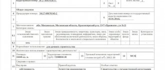
What does a land surveying project and its contents look like?
A standard boundary plan consists of two parts: text and graphic. Each part is also divided into sections. The paper version of the boundary plan is left on several sheets of A-4 format.
The graphic part is allowed to be compiled on larger format sheets. The MP in paper form is drawn up in at least two copies.
Text part
The text part is written on several sheets. If all the information is not reduced on one sheet, then you can write on the reverse side, but “Landing plan” must be written on each page. Continuous numbering of document pages is required. The text part includes:
- general information, as well as the immediate purpose of cadastral work;
- initial data, a list of documents that were used during the work;
- information about geodetic survey;
- information about the land plot and its parts, as well as about the real estate that is located on it;
- the listed work performed, how exactly the coordinates of characteristic points were determined, the boundaries of the site, measurement accuracy, area;
- a separate section for modified areas;
- section for new sites;
- possibility of access to the described area;
- conclusion of a cadastral engineer;
- act of approval.
If the site is just being formed, then the address, category of land, type of use, data from the Unified State Register, and cadastral number of the property are indicated.
The grafical part
The graphic part is also mandatory and includes several subsections:
- designation scheme for geodetic constructions;
- drawing of the site itself;
- site layout diagram;
- description of the outlines for the nodal points of the memory.
Depending on the type of land surveying plan, the mandatory and additional subsections vary.
Here's what a sample land plot plan looks like as an example:
When is it necessary to demarcate an allotment?
This work is carried out if:
- you need to allocate a share in kind and register ownership of it;
- there are disputes with other shareholders or neighbors;
- some kind of legal operation needs to be carried out with the plot - donate it, give it to the bank as collateral, sell it;
- you need to register ownership of a piece of land that is ownerless.
Please note: starting from 2021, land surveying is a mandatory procedure in order to enter an allotment into the Unified State Register of Real Estate.
How to choose a cadastral engineer for dividing a plot
The main criteria for choosing an engineer are to check all the necessary conditions for performing work in the cadastral field, the main ones being: a diploma and a certificate of membership in an SRO. It is recommended to check these documents before signing the contract. A specialist who carries out his activities officially will always provide supporting documentation.
Qualification certificate of the Chief Cadastral Engineer of SSG LLC
Kadnikova G.V.
Certificate of membership in the professional SRO of the Chief Cadastral Engineer of SSG LLC G.V. Kadnikov.
The process of division through court and other methods
In a situation where joint ownership of land in shared ownership is not possible and there is no agreed will of all participants, division can be carried out through the court.
To do this, you need to write a statement of claim and demand forced division. All costs of surveying can be divided between the participants in the process. When filing an application with the court, you need to remember the obligation to pay the state fee. The legal process for the division of land cannot exceed two months.
In case of allocation of a share on a voluntary basis, everything is based on the citizen’s application. It is submitted to the local administration. After obtaining permission, the necessary land surveying procedures are carried out, and the newly created land plot is registered.
Registration of land rights
Once you have been allocated a portion of your share and the proper boundaries have been determined, all you have to do is register your ownership at the local cadastre and cartography office. To do this you need to obtain the following documents:
- the act of agreeing on boundaries with neighbors;
- permission to separate land from former co-owners;
- land surveying project;
- act on the establishment of boundary signs.
With these documents you need to go to the cadastre and cartography department and register the land.
Then, having received the cadastral passport, collect a new package of documents for property registration:
- title document;
- cadastral passport of the land plot;
- act on the establishment of boundary signs.
With these documents and your passport, you can continue registering your property rights. Please note that after the land has been allocated, you only have the title document for the old share. For a new plot of land, confirmation of ownership will be an act of land surveying (installation of boundary markers).
The title you receive will not reflect legal precedent. Therefore, in the event of allocating a share from the common shared property, the survey document you received from a geodetic company will perform several important functions:
- determine the conditions for establishing (emerging) the right of ownership and use of the site;
- will give complete technical characteristics of the territory;
- will protect your land from outside attacks.
The deadlines for carrying out the work are negotiated with geodetic companies and are approximately equal to 15 calendar days, but are often completed faster. However, if you are put in a queue, it will definitely take extra time. An act of coordinating boundaries with neighbors can be drawn up and signed almost in one day.
Features of the allocation of agricultural land
The allocation of agricultural land presents some difficulties associated with the specifics of their category and purpose. All lands in this category are located in a massif on which land for pastures, fields and meadows is located.
Privatization of a small plot of land within a land mass complex may present some inconvenience for an economic entity. Therefore, the authorities are reluctant to allocate small parts - they prefer contractual lease terms. And this is not surprising - after all, the lease agreement does not impose obligations to alienate the land into ownership , as happens when it is allocated.
In most cases, the allocation of a plot is not made suddenly - it is a thoughtful and balanced decision on the part of the business entity. It is usually much easier to obtain a plot of land if it was initially leased.
Accordingly, individual entrepreneurs leasing land at a certain stage can allocate a plot of land with subsequent (or preliminary) registration of its ownership. In this case, the allocation will be made according to the same algorithm as in dacha cooperatives (partnerships), but permission from the local administration will be required.
It is prohibited to allocate agricultural land to:
- from specially protected;
- reserved;
- forest and water funds;
- characterized by particularly fertile soils.
The remaining lands can be allocated at the discretion of the local administration.