If necessary, perform such an action All persons are notified in advancedirectly interested in how the established boundaries will be drawn.
The role of such persons is the owners or users of adjacent plots .
This is due to the fact that incorrect drawing of boundaries can infringe on their interests by affecting their immediate property.
In some cases, coordination with neighbors for certain reasons becomes impossible - in such cases, the question arises about the legal validity of the drawn up boundary plan and how it is possible to survey a land plot without coordination with neighbors.
When a neighbor may not sign a land survey agreement
Let us examine in more detail whether it is always necessary to obtain the consent of neighbors when carrying out land surveying.
Depending on the situation and circumstances, the absence of a signature from the owner of an adjacent plot may be due to various reasons, including simply disagreement with the boundaries (that is, a neighbor came to the meeting, but does not want to sign) or the absence of a neighbor in the process of direct approval borders.
Error while defining boundaries
If in the process of carrying out calculations and subsequent placing the boundaries of the site on the ground, the cadastral engineer makes a mistake , it is quite possible that the passing boundary will not suit the neighbor, since it encroaches on part of his property.
In such situations, the owner of an adjacent plot has every right to refuse to sign and demand that inaccuracies be eliminated first, which can also be additionally reflected in the boundary plan.
Subsequently, if it turns out that there was in fact no error by the engineer, the owners of the site may have to resolve such an issue in court if they cannot come to a common opinion peacefully.
Long absence
A peculiarity of holding a meeting at which an agreement on establishing the boundaries of a land plot is signed is that information about this must be carried out within the period strictly specified by law - no later than 1 month before the meeting is held .
This provision was adopted so that plot owners could plan their time in advance to be personally present and sign as a sign of consent.
Despite this, in some cases, neighbors, even having received notification on time, do not have the opportunity to appear, since they are undergoing long-term treatment in a medical institution (sanatorium, etc.) or are in a remote place due to work issues related to the specifics of their work activity .
In such situations, the absence of such a person does not always become the reason for the impossibility of drawing up a boundary plan without his signature - in the absence of a statement of disagreement with the plan, the document drawn up may well have legal force .
The owner's heirs did not have time to enter into property rights
In some cases, situations may arise that at a certain point in time, when the boundaries of a plot are being determined, the adjacent land plot actually does not have an owner .
Such situations may occur if the direct owner of the plot has died and his potential heirs have not yet assumed their rights - 6 months have not elapsed from the date of death, or there is a property dispute.
In such a situation, since ownership has not been established, the heirs do not have the right to sign such an agreement .
Where to start: preparing documents
- First of all, it is necessary to prepare documents for land ownership.
- Then find the best cadastral engineer.
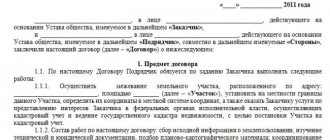
- Conclude a contract agreement with the performing organization.
Subsequent actions relate directly to land surveying work, as a result of which the customer receives two copies of the land survey plan.
IMPORTANT! One copy is kept by the owner of the land plot, and the second will remain with the state registration, cadastre and cartography authorities.
When can land surveying be done without the consent of neighbors?
When carrying out the procedure for approving boundaries in certain situations, on the basis of the Land Code of the Russian Federation and the Federal Law “On the Cadastre”, situations are identified when the absence of a signature of the owner of an adjacent plot does not become an obstacle to drawing up a boundary plan.
Let's consider in what cases land surveying without the presence of neighbors is acceptable.
No-show
In the event that the previously notified owner of the adjacent plot did not wish to appear at the approval procedure, and did not send his legal representative to attend or did not respond to the received notice with approval or refusal, his absence during such a procedure is automatically accepted as consent .
In such situations, it is necessary to clearly notify interested parties - only if there is strong evidence that notification took place, it will be almost impossible to challenge the boundary plan.
If the information is unknown
Sometimes, in the process of preparing boundary plans, plot owners and engineers are faced with the problem of lack of information about the owner of a neighboring plot, or his location is unknown.
Such situations also have their own solution - notification is made by publishing an announcement about the upcoming meeting and thus the person is considered automatically notified.
In some situations, a neighbor who has not shown up may subsequently challenge the passing boundaries, but this is quite difficult to do , since the truth is on the side of the engineer who followed the procedure for carrying out the notification procedure established by law.
Established boundaries for adjacent areas
Often, land surveying takes place in situations where boundaries have already been established for all adjacent sections, that is, this actually means that the approval procedure has already taken place and although it was carried out in relation to other sections, this means that there are no contradictions between neighbors, and all of them confirmed their agreement with the way the borders are drawn.
If the engineer, when carrying out work on the site, does not find any inaccuracies or errors and the passing boundaries will exactly coincide with the passing boundaries of neighboring sections, in such a situation approval is not mandatory .
On the other hand, some experts still advise, if possible, to perform this action , thereby protecting yourself from possible litigation related to the need to change the boundary.
How to do it?
Make copies of the documents on hand (you may have to have them certified by a notary).
Having determined which of the organizations that carry out land surveying is trustworthy and acceptable in terms of prices, you hire a specialist (to create favorable conditions for faster work, agree on phased payment - part immediately, part after drawing up the plan).
A hired specialist studies the available documentation and then goes to the area to determine the safety of official reference points.
The contact details of the neighbors in the area are sought, after which they are sent notices about the need to arrive on a certain date at their site to present (if required) claims on the boundaries.
If it is impossible to find contacts, notification is carried out with the involvement of local media (non-arrival of neighbors is not an obstacle to the land surveying procedure).
Taking into account the reference boundary signs, the boundaries of the site are fixed and its area is determined. The new markings are agreed upon with the neighbors .
Draw up a boundary plan, which should include:
- Data on the boundaries of the site and adjacent neighboring plots;
- Land area;
- Information about the methodology for determining boundaries;
- Data on changes in the size of the plot and adjacent plots;
- Information about easements (list of encumbrances on the site);
- Information that the new boundaries have been agreed upon with the owners of neighboring plots.
You can see how land surveying is done in the video below:
Invalid survey without signature
In certain situations, the signature of neighbors is necessary in order for the boundary plan to still have legal force and the passing border of the land plot to be recognized as valid.
The cases where a boundary plan cannot be recognized as valid without a neighbor’s signature are as follows:
- The neighbor's attendance at the meeting. At the same time, he expresses his disagreement with the passing boundary and, as a consequence, the boundary plan cannot be considered valid without eliminating the reasons for such disagreement;
- The neighbor sent an official letter in which he informed about certain requirements regarding the boundaries (in fact, disagreement with the way the cadastral engineer sees the location of the boundaries). In such a situation, there should also be an elimination of inaccuracies, an attempt to still come to an agreement with a neighbor or, as a last resort, go to court to protect one’s rights;
- There were no procedures in place to properly notify stakeholders. That is, even if there was information about the neighbor’s location, a notification was not sent to him.
A similar situation also applies if the neighbor’s residential address is unknown and an announcement about the meeting has not been published in the local media.
In this case, the neighbor has the legal right to subsequently protest the results of the land survey and the court will most likely be on his side.
How to change the boundaries of a site?
- Having purchased the adjacent plot/plots;
- Having received as a gift;
- By increasing the area of the land plot during land surveying.
Is it possible to increase the area of the plot?
It is possible to increase the area during land surveying in the following cases:
- The procedure is carried out after purchasing an additional plot or receiving a plot as a gift;
- In the process of determining the boundaries, it turned out that the owner owned a larger territory than he expected.
What to do if it is not possible to find the owners
If, during the preparation of the draft boundary plan, immediate neighbors could not be found, the owner of the site, in order to ensure that it is impossible to challenge the drawn up boundary plan, must strictly follow the requirements of legislative acts.
That is, in cases where the whereabouts of the neighbor are not known, it is necessary to comply with the existing procedure for notification in such cases - the original of the media in which the notification was published is attached to the boundary file as evidence of compliance with the required procedure .
Receive documents: what they look like
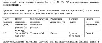
Order of the Ministry of Economic Development of the Russian Federation No. 921 dated December 8, 2015 (as amended on November 23, 2016), which entered into force on January 1, 2017, regulates the preparation of a boundary plan and an approval act. According to this document, the boundary plan looks like this:
Basic rules and regulations for land surveying
The parties participating in the process are obliged to comply with the land surveying rules established by the legislation of the Russian Federation:
- The procedure is carried out only by an authorized organization.
- Only the owner of the site can ask for help in carrying out the procedure.
- During land surveying, the owners of neighboring lands must be present.
- The survey act is signed by all interested areas. If neighbors have complaints about the boundaries of the plot, their statements are attached to the deed.
- The owner receives a land survey document, on the basis of which he can register the plot of land in the cadastral register.
List of required documents
How is land surveying done with neighbors? The first point in the order of land surveying is the stage of preparing all the necessary documents.
A person interested in land surveying must provide the following documents to the land management organization:
- documents that can confirm ownership of this site. This could be a purchase and sale agreement, a certificate of inheritance, etc.;
- applicant's passport;
- technical documents, for example, certificates from the BTI or cadastral passport.
A complete list of papers that will be required for land surveying is provided by the institution conducting this procedure. After submitting the documents, the applicant enters into an agreement with the cadastral engineer, after which a day is set when geodetic work on the site will begin.
Who implements it?
The land surveying procedure is a complex process, for which special equipment is used. Therefore, to carry out work, you should contact a land management geodetic organization, whose employees have all the necessary permits and licenses.
The activities of cadastral engineers are carried out on the basis of Federal Law No. 221 “On the State Real Estate Cadastre”.
Note: independently carrying out the process of land surveying has no legal force.
Read more about where to order land surveying and who does it here.
Notifying neighbors
In the vast majority of the applicant's property, it borders on neighboring territory. If land surveying takes place between neighbors, then they must be notified 7 days in advance.
A week's time is given so that people can attend this process and complete unfinished business.
Neighbors are notified in writing. You can download the corresponding form on the Internet, or draw up a paper in free form - indicating the date and time of the event. In practice it looks like this:
- All neighbors affected by the procedure are notified;
- Signatures with their consent are collected on the form;
- Before starting work, the completed form is given to the surveyor;
If neighbors do not show up within the specified period, the work is carried out without their direct presence. The consent signature has been obtained in advance, and absence is not a valid reason for canceling the perimeter determination.
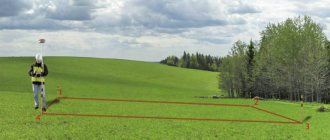
Techniques and methods of implementation
The main methods of land surveying and land management objects used by specialists can be called:
- Satellite. With its help, the coordinates of the land plot are established. The advantages of this method of surveying land management objects include the ability to measure large areas, accuracy of determination and surveying in any weather conditions.
- Geodesic. This method includes the use of polygonometry, forward, back or combined serifs, trilateration, etc.
- Photogrammetric. Land surveying is used to determine the boundaries of land.
- Cartometric. To carry out land surveying using this method, specialists study cartographic material that allows them to determine the coordinates of boundary markers.