Home / Real estate / Land / Land survey / Cadastral passport / Cadastral plan
Back
Published: March 22, 2017
Reading time: 11 min
0
869
Each land plot is subject to cadastral registration. Lands included in the Unified State Register of Real Estate must have an accurate description of their characteristics. Characteristics are described in both text and graphic forms.
The site plan is drawn up in accordance with the requirements of cadastral registration of land territories. The records are maintained by the cadastral service body, which is entrusted with maintaining the unified state register and ensuring the reliability of information about existing land plots. The cadastral plan, and along with it the entire cadastral passport, is extremely important for identifying a land plot and securing all information about it.
- Legislation
- Where can I get a cadastral plan of a land plot?
- How to get a cadastral plan for land? Collection of documents
- Filing an application
- Obtaining a cadastral plan
Reasons for receiving
Not every person can apply for cadastral documentation. For example, when a person does not have ownership rights to the plot, but temporarily resides on the land, having collected a complete list of papers and contacting the competent authority, he will be denied the issuance of a plan.
Those who have good reasons for this can apply for it. In this case, you need to know what grounds are required so that the application for documentation goes smoothly. The list includes:
When, at the time of acquiring a land plot, there is no document such as a cadastral passport. This can happen if, during the process of re-registration of documents for the new owner, it turns out that the previous owner has lost the cadastral acts.- It is also necessary to apply for a new document when the owner has lost it. In this case, you will have to pay a fine, which is established at the legislative level. The provision of documentation is carried out in a fairly short time.
- The basis is the purchase of land from government agencies. In this case, as a rule, a person independently finds a plot that is owned by the municipality, then visits the administration and submits a request to buy out this plot. The municipality sells the land, but the responsibility for paperwork remains with the purchaser.
Another important reason for drawing up new documentation is the procedure for annexation and detachment from other plots, which were previously considered as the total area of land. In this case, the plan is not subject to change, but a new one is created.
It is worth noting that, regardless of the form of land ownership, in the case of transactions with plots, it is necessary to draw up a new cadastral plan.
Ownership and taxes
After you receive your passport, a certificate of ownership is issued. This procedure must be carried out without fail within 24 months from the date of registration of the storage unit. This must be done, otherwise the land plot will become state property and lose the TIN number. After the relevant certificate is issued, the owner is obliged to pay taxes, the amount is calculated individually.
If the owner does not understand the legal aspects, experts recommend using the help of specialists in land registration. They will advise and tell you how to act.
Validity
The concept of deadlines is included in land legislation, as well as in other types of legislative acts, be it criminal, civil and other laws. Deadlines are considered as established time frames within which a particular action must be completed. Deadlines are to be established at legislative levels. Both the federation and regional and municipal authorities have the authority to establish them.
It is worth noting that in land legislation regarding issues of issuance and validity of documentation, this meaning works in a slightly different direction. Even if you study the Land Code most carefully, you will not be able to find exact deadlines regarding the receipt of the plan. This is due to the fact that this act does not regulate this issue.
In this case, questions arise related to how you can find out during what period the issued plan is considered valid, and when the document has already become unusable.
It is worth saying that the validity period of the documentation is calculated as follows: when all objects, boundaries and other features inherent in the plot are in accordance with what is indicated in the plan itself, the document will be valid for the entire time, without taking into account how much time has passed since its issuance .
If something changes on the territory, including the construction of a new building, the landscape, boundaries and other nuances, the owner must immediately contact the competent authority and submit an application for new cadastral documentation. This rule applies regardless of the category of land.
Document form and sample
The document form consists of 5 sections :
- Indication of general information about the site. This includes the name of the state registration organization, registration number, area, current rights, and intended purpose.
- Information about boundaries in graphical form.
- Description of boundaries, information about neighboring areas.
- Text data about parts, if available.
- Details of parts, if any.
Borders are represented as outlines.
Sample cadastral plan:
How much does it cost to order?
The fee for preparing cadastral papers depends on several factors. First of all, the amount paid as state duty is taken into account. Often, when the situation is standard, the amount of state duty is no more than 300 rubles.
Sample extract from the Unified State Register of Land Registers for a land plot
The applicant also pays for the preparation of a boundary plan. This cost is also created from several components, including the fact that a specialist goes to the site and carries out the necessary work on the site. Payment for the work of a cadastral engineer is carried out at the Rosreestr branch. This body issues certificates indicating the amount to be paid.
In a situation where the owner has boundary documentation in his hands, he is exempt from paying the specified fees for drawing up the act.
It is worth noting that the total cost of preparing the documentation is not large, so there is no point in delaying the registration of the registration authorities.
Types of cadastral works
Cadastral work can be carried out on any real estate. Here are the main types of cadastral work regulated by Laws No. 221-FZ and 218-FZ:
- work on sites - surveying, defining and coordinating boundaries, placing boundary signs on the ground;
- work on capital construction sites, in premises - determining the characteristics of a newly erected structure and premises, measurements and surveys after the completion of redevelopment of apartments or other objects, reconstruction, refurbishment;
- work on an object that has lost its physical existence - an inspection report is issued to confirm this fact;
- complex cadastral works - for groups of objects.
Additional types of work include assessing the condition and safety of a structure, preparing opinions at the request of the court or on other issues. Based on the results of each type of work, different documentation is drawn up. We will tell you more about the procedure for preparing basic documents below.
What cadastral work did you order?
Land surveying and determination of site boundaries
83.33%
Cadastral work in a room or building with the preparation of a technical plan
0%
Inspection of an object that has lost its existence
16.67%
Voted: 6
Technical plan for cadastral work
The technical plan is drawn up for buildings, structures, premises, and other types of structures. The document contains a text description of the object and its characteristics, a graphic diagram. The services of a cadastral engineer in preparing a technical plan include the following activities:
- obtaining and analyzing initial documentation for the object - this list may include contracts, USRN extracts, certificates of title, BTI technical passports, and other types of documents;
- request and analysis of initial information from the Unified State Register of Real Estate for an existing facility (if available);
- on-site work - visual inspection, examination, measurements, surveys, calculations, other types of measurements;
- preparation of a text description of the obtained characteristics;
- preparation of the graphic part of the plan - diagrams, floor plans showing all premises.
The cost of cadastral work for drawing up a technical plan is differentiated by the type of object (room, building), its area, number of floors, and other factors. The finished technical plan is issued on disk or digital media, or transferred to Rosreestr through electronic document management. The document is certified by the engineer’s digital signature. Read about the specifics of drawing up a technical plan when dividing objects in our previous material.
Sample technical plan:
Calculator of the cost and timing of our services - here
Boundary plan for cadastral works
The boundary plan is prepared after measurements and inspection of the sites. When you need to inspect and obtain the characteristics of a house and site, you can simultaneously order a boundary and technical plan. If land surveying is ordered, cadastral work will include:
- studying the source documentation provided by the customer;
- request and analysis of EGRN information, including information on nearby plots (this is necessary to correctly determine boundary points);
- work on the site - measurements, surveys, determination of boundary points using high-precision equipment;
- description of the coordinates of boundaries and other characteristics in the text part of the boundary plan;
- preparation of a diagram showing the boundaries and buildings on the site.
The services of a cadastral engineer after land surveying include the preparation of an approval act. These activities are carried out in accordance with Art. 39 of Law No. 229-FZ. The boundary approval act must be signed by the owners of all adjacent plots. To do this, you can hold a general meeting, or resolve the issue individually. Although the engineer is not required to carry out coordination, such additional services can be provided by the cadastral company.
Sample boundary plan:
Inspection report for cadastral works
To confirm that the object has ceased to exist, cadastral work is also carried out. After inspecting a destroyed, dismantled or demolished structure, an inspection report is drawn up. Based on this document, Rosreestr employees will cancel the cadastral number and exclude information on the building from the Unified State Register of Real Estate.
Expert commentary . By ordering surveys, measurements, land surveying, cadastral works of other types from the company MSR Architectural Bureau, you will receive a guarantee of quality, affordable prices, and professional assistance in registering rights and approving documents. Our cadastral engineers have been working in the market for a long time, they know all the nuances of interaction with Rosreestr. For all types of services you can request a free consultation.
An inspection report is issued for an object that has lost its physical existence
Procedure and instructions
At the initial stage of obtaining cadastral papers, it is necessary to collect the necessary documents. Next, the owner of the plot needs to draw up and submit an application to the authorized body. Then the state fee is paid. When the above steps are completed, a person needs to apply with the entire package of papers to the Cadastral Chamber, where the state land cadastre is maintained.
Next, you need to wait for a response within one month, after which a plan will be issued.
Sample application for registration of rights to real estate
It is also necessary to understand the nuances of the action in question. It is necessary to pay attention to the fact that, if necessary, it will be possible to obtain cadastral documentation only when the land has previously been registered in the cadastral register for at least a short period of time. In a situation where the site has not previously been registered, it will be necessary to take actions aimed at registering for this type of registration.
Before receiving cadastral documentation, you must ensure that you have a boundary plan. This action is carried out by a specialist called a cadastral engineer. This person is responsible for the correct preparation of cadastral papers. Any actions related to land surveying are carried out by him on a paid basis.
What is cadastral work
Cadastral activities are associated with receiving, processing, and summarizing information about real estate. For this purpose, measurements, surveys, and other work are carried out. The exact characteristics of each object (land plot, building, premises, etc.) are reflected in a single federal database - EGRN (Unified State Register of Real Estate). The Unified State Register is maintained by Rosreestr specialists. However, they receive all data for accounting and registration from the documentation issued by the cadastral engineer.
Carrying out cadastral work is necessary in the following cases:
- during the formation of an object - after the construction of buildings, the formation of a site, division or allotment of plots with the appearance of newly created objects;
- when changing data previously entered into the Unified State Register of Real Estate - based on the results of redevelopment, reconstruction or redevelopment, transformation of sites;
- when the physical existence of a structure is lost - during dismantling, demolition, destruction.
We will separately highlight complex cadastral work. They are carried out simultaneously on groups of objects located within a cadastral block or several blocks. For example, such work is ordered by authorities to determine the cadastral value and prepare urban planning documentation. Even ordinary citizens constantly order work in the field of cadastre - after completion of redevelopment, during the allocation or division of plots, for registration of private houses of individual housing construction in Rosreestr.
Expert commentary. Carrying out cadastral work involves determining the exact characteristics of real estate. For this purpose, the requirements for accuracy and methods for determining the coordinates of borders, approved by Order of the Ministry of Economic Development of March 1, 2016 No. 90 (), are applied. Also, Article 29 of Law No. 221-FZ specifies special requirements for cadastral companies and engineers. In particular, engineers are required to undergo certification and receive a certificate. The cadastral company is obliged to be part of the SRO and to have certified specialists on its staff.
Based on the results of cadastral work, registration is carried out in Rosreestr, and an extract from the Unified State Register is issued.
In simple terms
The purpose of cadastral work is to produce documentation with the characteristics of real estate. This is necessary to enter data into the Unified State Register. The work can be ordered by owners, tenants, government departments, and other property owners. Before the transition to the cadastral registration system, the characteristics of objects were determined and entered into the registers of the BTI institution. Until the end of 2021, citizens could provide information about the parameters of real estate by filling out a declaration. Only after the transfer of powers to cadastral engineers did the state achieve accuracy and reliability of data for all objects.
Cadastral work is carried out according to the following rules:
- the copyright holder selects a cadastral company or engineer, transfers documentation, and enters into an agreement;
- the engineer requests information from the Unified State Register of Real Estate for the subject and nearby objects, studies the documentation;
- inspections are carried out on the site, in the building, premises;
- the results of the work are recorded in one of the documents - a boundary or technical plan, an inspection report;
- documents prepared by the engineer are transferred to Rosreestr for real estate accounting and updating of the Unified State Register.
Cadastral services may include the elimination of registry errors, preparation of conclusions, removal of boundary markers in kind, and additional types of work. This is determined by agreement with the customer.
Carrying out cadastral work entails another important nuance. Since engineers are professional certified specialists, they are responsible for the accuracy, completeness and reliability of information about the parameters of real estate. Current control and supervision over the activities of cadastral companies is entrusted to the SRO, Rosreestr.
Calculator of the cost and timing of our services - here
Cadastral works and services. Questions to the expert.
Soloviev Petr
Expert in the field of certification, cadastre, real estate and design. Higher legal education, more than 10 years of work experience.
Ask a Question
Question to the expert
Good afternoon How often do you need to order cadastral work for a land plot?
Cadastral work is carried out for initial registration in the Unified State Register of Real Estate, with each subsequent change in the characteristics of the site.
If you carry out cadastral work yourself, will the documents be accepted by Rosreestr?
No, cadastral registration in Rosreestr is carried out only on the basis of documents issued by a cadastral engineer.
Hello! Do I need to show a technical plan for an apartment when selling it?
A technical plan is not needed for a purchase and sale transaction. But the document can be used to coordinate redevelopment if the seller has previously gone through this procedure.
Legally
All types of cadastral work and completed documentation must comply with the following regulations:
- Federal Law No. 221-FZ “On Cadastral Activities” ();
- Federal Law No. 218-FZ “On State Registration of Real Estate” ();
- Orders of the Ministry of Economic Development of the Russian Federation, which approved the forms and contents of documents issued by cadastral engineers;
- GOSTs, in accordance with which methods of examination, calculations, and measurements are selected.
Documents are prepared in electronic format, issued on disk, or immediately sent to Rosreestr. If the client is interested in technical or boundary plans, documents executed on paper, this must be separately provided for when agreeing on the terms of the contract.
Expert commentary. From the moment the data is transferred to the Unified State Register, the documents issued by the engineer will no longer be valid. They can be used for information and reference purposes, while official data must be requested in the form of an extract from the Unified State Register of Real Estate. Subsequently, whenever the parameters change, you need to contact the cadastral company again and receive a document with current data on the object.
Refusal to issue: what to do?
We should not forget that in some situations applicants may be denied the issuance of the act in question. The reasons for this action can be very diverse, but a person should prepare for them in advance in order to know what to do in the future. As mentioned earlier, the first reason for refusal may be the lack of an appropriate certificate confirming the right to the allotment.
This means that based on the documentation in accordance with which the transaction aimed at buying and selling land was carried out, the competent authority cannot issue a plan. They may also refuse if the applicant has not paid the state fee. This is due to the fact that it is its payment that is presented as payment for the actions of employees of the competent authorities.
Example of a decision to suspend accounting
A refusal can also be issued in the case where a completed application is missing or it is written incorrectly. In this case, there is no point in counting on receiving a plan. In this case, you can correct the situation by writing and submitting an application.
Also, employees refuse to issue the requested acts in a situation where there is no information about the data of the document through which the applicant’s identity is verified.
In practice, this looks like providing evidence of ownership, but no one can be sure that the applicant is the owner. In this regard, before visiting the cadastral authority, it is required to prepare a passport and make a photocopy of it.
A refusal is possible when the site is subject to shared ownership, but the remaining owners have drawn up a statement in which they refused to issue such documentation or did not express their will at all.
Why is it needed?
A specialized map of the area with text and graphic display of characteristics - this determines the use of the document.
Cadastral and boundary plans are drawn up by specialized geodetic organizations that have the appropriate permission to carry out such work.
List of cases that require a plan:
- State registration of land.
- Dividing the site into several parts.
- Correction of USRN errors.
- Allocation of a share in the ownership of real estate.
- Transfer of ownership of the site.
- Refinement of location and normalization of boundaries.
- Formation of a new site from municipal property.
- Unification of lands.
- Resolution of litigation.
How to order CBT electronically?
You can order a plan electronically using the Rosreestr website. Two situations may arise:
- when the site is not registered;
- is on the cadastral register.
First, you need to consider the situation when you are not registered. In this case, you need to do the following:
- log in to the official portal of the specified body;
- select the subject of the appeal (at the top of the page there are tabs for citizens, organizations and specialists, you need to select the appropriate one);
Obtaining information from the USRN for individuals - click on the column on the right “Obtaining information from the Unified State Register of Real Estate”;
- fill out the form that opens (if there is a conditional or cadastral number of the plot, enter it);
Form for entering cadastral number - Next, fill in information about the applicant;
Filling out information about the applicant - entered data is checked;
Form for checking entered data - the method of providing data is selected;
- click on the “Send request” button;
- then a letter is sent to the specified email address, where you should pay attention to the payment number, the amount of payment that needs to be made, and also contains a link to the payment that needs to be followed;
Notification letter about pending payment - follow the link from the letter and enter the payment code in the line;
- choose the method by which payment is made;
Possible payment methods - remit payment;
- Expect a response within five days.
When the applicant does not want to waste his time obtaining data using Rosreestr and filling out the data, he has the opportunity to use the services of intermediary companies. Prices for services vary depending on which company is chosen.
If you look at the average price for such services, they are paid from 4 to 8 thousand rubles. While completing this documentation yourself costs the applicant almost free. For example, citizens pay a fee equal to 50 rubles, organizations - 300.
If third-party organizations are used, their services are paid first. This includes preparing a full package of documentation, contacting Rosreestr and other actions.
When the land is registered, you can get a plan through the Rosreestr website like this:
- log in to the site;
- select a section according to the status of the person applying;
- then the “Electronic Services” column will open, which you need to click on;
- choose to receive information from the Unified State Register of Real Estate;
- click on the item “Get cadastral plan from the territory of the Unified State Register of Real Estate”;
Form for obtaining a territory plan from the Unified State Register of Real Estate - fill out the form that opens on the page;
- choose the type in which the finished document will be received (the form can be written or electronic);
- indicate your place of residence or email address depending on the chosen method of receipt;
- carefully check the entered data;
Checking data to get a plan - click on the “Submit Application” button;
- wait until you receive an email containing a payment link;
- follow the link and enter the payment code contained in the previously indicated letter;
- select the method to be used for payment;
- make a payment;
- Expect the document to be produced within 10 days.
It is also possible to use the services of intermediaries, but it is worth noting that drawing up a plan without a cadastral passport will cost much less. The average price ranges from 500 to 2 thousand rubles. This amount depends on the region of circulation and the company providing such services.
Example of a plot plan
In a situation where not one of the above methods cannot be used, there is another option for resolving the issue - turning to the Public Cadastral Map. This resource is free, which means that even state fees are not subject to payment.
Search operations are carried out using the cadastral number of the plot or the address of its location. This method is used in cases where it is sufficient to provide brief information about the site. Using it you can get information about:
- cadastral value;
- total area of the territory;
- date when registration was carried out;
- when changes were made to the Unified State Register of Real Estate;
- plot area, which has a specified value.
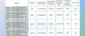
Cost of cadastral works
The cadastral company has the right to determine the cost of services and work itself. Prices are based on the following factors:
- object location;
- season of work;
- unique characteristics of the object (area, number of storeys, height, etc.);
- the number of objects for which you need to collect data and draw up documents (for example, if you need to draw up technical plans for several premises or buildings);
- short deadlines for completing work.
Naturally, the larger and more complex the object, the more expensive the cost of work will be. Prices are agreed with the customer after a preliminary analysis of the documentation. Complex cadastral works are usually carried out based on the results of tenders, i.e. on a competitive basis.
How to do it yourself?
If we talk about the cartographic basis of the earth, it is transferred to media in electronic and paper form through the use of satellite communications. This means that the error in the compiled documentation is minimal. This information is used by special bodies conducting relevant activities. In some cases, plot owners are required to make a copy of the cadastral plan.
The above conditions give reason to believe that the land owner cannot draw up a plan on his own, so in any case it is necessary to contact the competent authorities to provide the necessary papers.
Samples of cadastral works
We invite you to familiarize yourself with samples (examples) of documents prepared by our specialists.
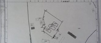
Sample 1. An example of a diagram of geodetic construction of a boundary plan made by our specialists.
Sample 2. An example of a structure layout in a technical plan prepared by our bureau.
Receive a document from Rosreestr
To obtain documentation for an allotment, you need to contact a multifunctional center or a branch of Rosreestr. These organizations must be located in the same location as the site about which information is being requested. You will need to provide:
- a receipt confirming that the state duty has been paid;
- a document by which a person’s identity is verified;
- certificate indicating the existence of ownership rights to the plot;
- if a representative participates, a document confirming his authority.
Sample certificate of state registration of property rights
When a specialist receives the listed papers, a receipt is issued indicating their list, as well as the date when you need to visit the authority again and receive a completed act.
When the allotment is not registered, in addition to the specified papers, you must submit:
- boundary documentation;
- a certificate indicating the existing restrictions on the land;
- an act that indicates which category the site belongs to;
- land permit;
- if the property is shared, then a land surveying plan is required, which is agreed upon;
- availability of evidence regarding the share in common property.
Boundary plan of the allotment
The listed documentation should not contain errors or inaccuracies. Certification is carried out by affixing the signature of the employee of the cadastral authority who issued the receipt for acceptance of the papers. The period allotted for preparing papers is 20 days. When information about the allotment is available in the state database and it is registered, then papers are issued within 5 days.
It is worth noting that the registration process is quite important and in the case when all the papers are not submitted within 18 days, it begins again. If there is no registration in Rosreestr, then you need to submit an application for the provision of boundary acts, as well as prove that the person is the owner of the land.
Where can I get a cadastral plan of a land plot?
You can make a cadastral plan in one of the following ways:
- Apply in person with a completed application on paper to the Multifunctional Center (MFC) or to the territorial office of Rosreestr;
- Send documents to Rosreestr by mail;
- Use the services of a representative;
- Use the online request on the official website of Rosreestr;
- Use the Unified Portal of State Services.
Important! Since 2014, the Federal State Unitary Enterprise “Rostekhinventarizatsiya - Federal BTI” (simply popularly known as BTI) has been included in the list of subordinate organizations of Rosreestr. All issues related to the provision of documents and information are transferred to the competence of Rosreestr. Rosreestr is also known as the Federal Service for State Registration, Cadastre and Cartography.
Get from USRN
Amendments were made to legislative acts, according to which the State Property Committee was abolished and in its place the Unified State Register of Real Estate (USRN) was created. It included all the information from the State Control Committee. An extract issued by the specified authority is valid for five years. After this period of time, the information is considered out of date.
Citizens, as well as organizations, have the right to complete documentation by personally contacting Rosreestr or by accessing the official portal of this body. The actions that will need to be taken to receive the document electronically are listed above.
Contents and sections of the plan
The land plot plan is placed on several sheets and consists of six sections. The first section contains the details of the customer and contractor, the date the document was drawn up, source documentation and measurement methods used by the engineer during preparation. As well as the following characteristics of the object:
- location;
- square;
- land category;
- type of use.
The second section is a diagram drawn up after the survey, with external outlines and turning points. The graphic image shows the territory, a specific object in the total mass is highlighted with red lines.
The third section is included if there are encumbrances or restrictions on property rights on the land. For example, the property is located in a protected area.
The fourth point is a drawing that shows the relationship of the land with nearby objects.
The fifth section includes a table describing the coordinates of neighboring lands and their cadastral numbers.
The sixth part includes a table with nodal and turning points of allotment lines.
Alteration
Through the procedure for making adjustments, any changes that have occurred on the land plot are taken into account. This process is required:
- when ownership rights are transferred to another person;
- the area of the plot changes towards increase or decrease;
- new buildings with residential or non-residential significance were erected on the territory;
- when the area indicated in the documentation differs from what is actually available;
Application for state cadastral registration of changes in real estate - there have been changes in the address at which the plot is located;
- if the adjustments relate to the intended purpose;
- the value recorded in the cadastre changes;
- natural objects appeared on the site or, on the contrary, disappeared, including ponds, forests, etc.
To make changes, you need to collect a certain package of documents and visit Rosreestr.
Obtaining cadastral documentation is a simple process. The main thing is to prepare all the documentation in advance and carry out the necessary work. All documentation relating to the land plot must be prepared by the owner immediately.
Useful video
Watch the video on the topic:
Our website contains other articles about this cadastral document, namely:
- How to check the plan of a land plot online, including by cadastral number on the Rosreestr website?
- Why do you need a diagram of the location of the land plot on the cadastral plan and what do the red lines on it mean?