Cadastral plan of a land plot is a document containing a cartographic basis and a technical description. It contains the basic data of the memory, and displays buildings and small structures (garages, outbuildings, etc.) erected on this land. Also, using it, you can highlight zones on the site and neighboring objects. To register, you must have this document with you; it is part of the site’s passport. What other information is needed will be discussed further in the text.
Why do you need a plot plan?
A cadastral plan of a land plot is necessary if in the near future the owner of the plot wants to sell, exchange, or donate it to a legal entity or individual. Also, the presence of a cadastral plan is required when constructing any structure on a direct land plot, for mortgage lending, registration of encumbrance, or changing the category of allotment. In the event of a conflict with neighbors, it will need to be submitted to court.
If this document is missing for some reason, the owner, in the event of a technical accident or natural disaster, may be left without support from the local administration, even minimal compassion. The owner of a land plot may also not be officially recognized as his real estate. As noted earlier, this document is an addition to the main passport. Therefore, without it, registration of rights and registration is impossible.
It is necessary to update the cadastral plan of a land plot if significant changes have been made to the site (for example, construction, moving boundaries, etc.).
Reasons for receiving
The cartographic basis of the earth's surface is transferred to electronic and paper media via satellite communications and recorded with precision instruments that allow minimal error. It is used for the multidisciplinary needs of various institutions and departments. Sometimes situations arise when the owner of the plot or its title owner needs to make a copy of the plot map.
Since 2008, after the Federal Law on the activities of the State Property Committee, No. 221-FZ, came into force, information from the cadastral passport and cadastral plan are considered legally interconnected. While before the designated period, the cadastral plan was the only technical document. You can learn more about the differences between a cadastral plan and a passport in this article.
The cadastral passport succinctly indicates the data taken from the topographical indicators of the plan . Any discrepancy in the documents becomes the basis for searching for a cadastral or technical error. Therefore, any error found in the land plot passport (LP) becomes a cause for concern and, as a result, a reason to contact the State Committee for Land Management. In addition, a plan may be required:
- in case of loss of the cadastral passport;
- when replacing an old cadastral number with a new one;
Read more information about the old and new KN here. It is also recommended to know how to decipher the data indicated in the cadastral number. - when registering a storage unit;
- when challenging boundary boundaries with neighbors in court;
- when purchasing a land plot from the municipality.
It is impossible to obtain the cadastral plan itself; the owners of land plots have access only to its copies, which are stored in the information bank of the State Property Committee and are issued in the form of an extract on paper.
In order to receive such an extract, it is required that the land plot be registered with the cadastral register. This is the main reason for having a ready-made plan. If the allotment is not properly registered, an extract will need to be prepared, starting from the first stage - land surveying and drawing out the boundaries of the site in kind, having agreed on them with the neighbors.
Where to get a cadastral plan
The applicant needs to contact the local FMS office or the MFC. Bring with you the completed application form and your personal passport. If there are any difficulties filling out the fields, an employee will help you sort them out.
You can also send a request through the post office; the application is drawn up in free form. Be sure to provide the following information:
- To whom - the head of the Rosreestr department, from whom - the applicant’s personal data.
- Indicate technical and cadastral information, as well as the address of the location of the land plot.
- The reason for the application is an extract from the cadastral plan.
If the plot has not been previously registered, then the owner of the plot must prepare the following package of documents: passport, boundary plan with agreed boundaries, receipt of payment of the fee. The amount depends on whether registration procedures have been carried out: if not, 350 rubles. Otherwise, you will have to pay 150 rubles less. To find out exactly, you can go to the official website of the MFC, and there you can familiarize yourself with the prices and package of documents.
What to do if you refuse?
An official of the cadastral chamber of Rosreestr has the right to refuse to carry out work on preparing a cadastral plan for a land plot. To do this, experts refer to current legislation.
The reasons for refusal may be the following:
- The land does not have the characteristics of a real estate property.
- The application does not comply with the provisions of the Law “On State Registration of Real Estate” in content and form.
- If division or other actions with the land plot are prohibited.
- The application was submitted by a person who does not have the right to represent the interests of the owner.
- The boundary plan was not drawn up properly.
- When making a request to a third-party organization, it turns out that there is no information about the land.
Obtaining a cadastral passport through the Rosreestr website
This is the simplest and most popular way, since everything can be arranged without leaving the threshold of your own home.
So, step by step instructions:
- First of all, you need to go to the official website, then go to the section “Obtaining an extract from the Unified State Register of Real Estate for individuals/legal entities.”
- Fill out the form provided: determine the type of document, indicate the email or postal address (choose a convenient method of receipt).
- Pay for the service.
That’s it, now after 5 working days you need to receive the cadastral plan in your hands, during a personal visit to the Rosreestr.
When using the electronic system, the user may encounter the following problems:
- If your personal device does not have the necessary extensions, the public map may not open or may not work correctly. For example, difficulties may arise when moving it away/approaching;
- The object requested by the user is not displayed, an error occurs. This may indicate its absence from the database;
- Small font in pop-up dialog box;
- If an electronic signature is forged, it is a crime;
- There may be difficulties in submitting your application;
- During scheduled maintenance, it is impossible to use the service.
However, users note that it is easier to obtain the requested data. But when using the site, it is important to protect personal information to prevent attackers from gaining access to it.
Where and how to apply?
Based on the cadastral plan, a cadastral passport is made. With the help of a cadastral passport, the owner carries out transactions with real estate, including the transfer of ownership or its confirmation.
An order for the production of a cadastral plan can be made in any of the ways where it is convenient:
- Through the cadastral chamber of Rosreestr or the MFC, when visiting these institutions.
- By online ordering - remotely, through the websites of Rosreestr or State Services.
Documentation
Before placing an order for the production of a cadastral plan, it is necessary to collect documents that will serve as confirmation of the basis for the work being carried out. If there is no state registration for a property, it must be registered in the prescribed manner.
List of documents if the site is not registered :
- Application - completed during the reception of a citizen or representative of a legal entity. This is done by a specialist or the applicant himself when ordering online through a special form.
- Application for state registration, if there is none.
- Passport or notarized power of attorney of the representative. For the head of an organization, minutes of the owners' meeting or an order of appointment to the position are needed.
- For a registered land plot - documents confirming ownership. This is a cadastral passport, certificate or extract from the Unified State Register.
- Boundary plan.
- An act of coordination of boundaries with the owners of neighboring plots.
- If the land is in shared ownership, then the consent of all owners is required.
The boundary plan must be ordered from a third party. Which has the right to carry out work to establish the boundaries of land plots.
It should be taken into account that the land surveying procedure takes a long time and is expensive . It is advisable to take care of registering the land plot in cadastral registration in advance. This way you can save a significant amount of time.
Required documents for a registered land plot :
- Application from the owner of the land plot or his representative.
- Receipt for payment of state duty.
- The owner's passport or a power of attorney of a representative with his passport.
- Title documents for land.
In the power of attorney for an individual, the notary must state the granting of the right to carry out registration and other actions of the representative with the land plot.
The right to apply to state registration organizations - the MFC, the cadastral chamber of Rosreestr, land management organizations and other government agencies whose activities are related to work in the real estate sector - must also be stated.
Registration in Rosreestr or MFC
This registration procedure provides that the organization will need to physically visit to submit an application. The application procedure is the same for both organizations. However, when contacting the MFC, the production time is slightly longer - it will take time to send the documents, but more on this below.
Interested parties should note that there is a waiting list. To avoid waiting in line, you should make an appointment with a specialist in advance.
During the reception, an official of the MFC or the cadastral chamber of Rosreestr will fill out an application and give it to sign, and accept the documents necessary for drawing up a land cadastral plan.
The applicant will be given the right to choose to receive a ready-made cadastral plan for the land plot:
- In the cadastral chamber.
- Through MFC.
- Electronic document by email.
Online
Rosreestr provides users with the right to independently prepare documents. The State Services portal is also engaged in this type of activity. Please note that the user must be previously registered on the Rosreestr website and the State Services portal.
Procedure for registration through the Rosreestr website :
- Go to the Rosreestr website.
- Select the required section - individuals or legal entities.
- The page “electronic services” will open.
- Click the item - obtain information from the Unified State Register.
- Fill out the electronic form.
- You can pay for government mail remotely. Cadastral chamber specialists will receive notification of payment automatically.
Registration through the State Services portal :
- Log in to the portal using your credentials.
- On the main page, enter the service catalog.
- Next, select Rosreestr from the list.
- Select the required service.
- Choose the method where you want to receive a ready-made cadastral plan of the land plot.
- Will pay the state fee.
The personal accounts of the State Services portal and Rosreestr are connected. Therefore, when redirected to the Rosreestr website, the user will not have to log in again. In your personal account you can track the status of your order .
Deadlines
Production times depend on which organization the applicant contacts.
When contacting the cadastral chamber :
- The period is counted from the moment the application is submitted.
- Readiness is 5 working days.
When registering through the MFC :
- Readiness begins to count from the moment the documents are transferred from the MFC to Rosreestr.
- The applicant will receive a notification about the transfer of documents.
- Transfer usually takes 1-2 business days.
What to pay attention to
When receiving the cadastral document, you must pay attention to the correctness of completion. To do this, check both copies: the information should not differ. The first and second sheets of the extract must contain a serial number, as well as the signature of the registrar.
The documents must display the following information:
- Cadastral number.
- Location.
- Destination category.
- Purpose of provision.
- Square.
The column “Special notes” may indicate information about the applicant’s rights and clarification of the area of the land plot. Other additional information may also be provided.
Basic Concepts
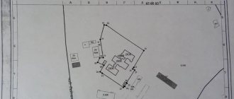
A cadastral plan is a document consisting of text and cartographic information. It displays the actual area, shape of the plot of land and the location of its boundaries. Order of the Ministry of Economic Development of Russia dated June 20, 2016 No. 378 approved the form of the Cadastral Plan of the territory.
The plan is drawn up not only in relation to the land plot. Houses, garages, and country houses are also subject to topographic registration. These structures are directly connected to the ground, and therefore are not taken into account in the plan separately from the site.
The cadastral plan confirms the legality of all transactions made with a land plot (sale, exchange, donation, etc.), as it acts as a direct confirmation of the entry of data on a specific plot into the State Real Estate Cadastre. In addition, the document certifies ownership of the land, since it contains information on the basis on which the cadastral number was assigned to the plot.
On the basis of the cadastral plan, the rules for the use of plots between neighbors are regulated, because it establishes the exact lines of demarcation between the territories of the plots.
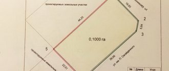
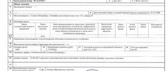
The structure of the document includes 5 sections. It looks like this:
- General information about the plot of land:
- information about the owner or tenants;
- location address;
- area and coordinates of boundaries;
- the purpose of cadastral registration;
- name of the body that entered the data into Rosreestr;
- allotment number;
- plan registration number.
- A drawing showing the boundaries of a real estate property.
- Text description of boundaries indicating adjacent land users on the territory.
- Data on parts of the land plot.
- Graphic information about the boundaries of the parts that make up the total area of the site.
Ownership and taxes
After you receive your passport, a certificate of ownership is issued. This procedure must be carried out without fail within 24 months from the date of registration of the storage unit. This must be done, otherwise the land plot will become state property and lose the TIN number. After the relevant certificate is issued, the owner is obliged to pay taxes, the amount is calculated individually.
If the owner does not understand the legal aspects, experts recommend using the help of specialists in land registration. They will advise and tell you how to act.
How is the cost formed?
The fee for receiving a paper statement is 200 rubles. for individuals and 600 rub. for legal entities.
The electronic version is cheaper: 150 rubles. for a private person and 300 rubles. for legal.
The total cost depends on the cost of creating a boundary plan. It is calculated based on the location of the site, its area, and the need to install (restore) boundary signs. The average cost of the service is 10-25 thousand rubles .
If a representative by proxy is involved in registration, the cost increases.
Refusal and appeal
The issuance of a cadastral plan may be refused, but it must be based on the regulations of the current legislation. A legitimate refusal should be considered: it is impossible to provide information from the Unified State Register, or there is no information in the database for the requested land plot. Everything else is decided by filing a statement of claim in the district court.
The refusal must be received by the owner of the land plot within 5 days, excluding weekends and holidays, from the moment of acceptance of the main documentation and registration. The decision of the registration authority can be appealed by contacting the competent services.
Reasons for refusal:
- The applicant is not the owner of this land plot and has not provided a certified power of attorney.
- Errors were found during registration.
- Missing one (or more) documents. Clients often forget to provide a receipt indicating payment of the state duty.
- The boundaries of the land plot have not been established (the land plot has not been demarcated). It is necessary to carry out land surveying and coordinate the boundaries with the owners of adjacent plots. Order the service from a geodetic organization based on the location of the real estate property.
The deadlines for completing land surveying depend on the company. But often this process takes about 20-30 days.
Validity
The current plan has no time limits. If the topographical information reflected in it has not lost its relevance, it is preserved, and in the cadastral passport replaced on its basis, the information from the plan is duplicated.
Since a passport needs to be replaced once every 5 years , land information may become outdated. In this case, you will have to redo the plan. In addition, the plan is replaced with any reorganization of the site, changing its parameters and technical characteristics.
Alteration
Through the procedure for making adjustments, any changes that have occurred on the land plot are taken into account. This process is required:
- when ownership rights are transferred to another person;
- the area of the plot changes towards increase or decrease;
- new buildings with residential or non-residential significance were erected on the territory;
- when the area indicated in the documentation differs from what is actually available;
Application for state cadastral registration of changes in real estate - there have been changes in the address at which the plot is located;
- if the adjustments relate to the intended purpose;
- the value recorded in the cadastre changes;
- natural objects appeared on the site or, on the contrary, disappeared, including ponds, forests, etc.
To make changes, you need to collect a certain package of documents and visit Rosreestr.
Obtaining cadastral documentation is a simple process. The main thing is to prepare all the documentation in advance and carry out the necessary work. All documentation relating to the land plot must be prepared by the owner immediately.
Get from USRN
Amendments were made to legislative acts, according to which the State Property Committee was abolished and in its place the Unified State Register of Real Estate (USRN) was created. It included all the information from the State Control Committee. An extract issued by the specified authority is valid for five years. After this period of time, the information is considered out of date.
Citizens, as well as organizations, have the right to complete documentation by personally contacting Rosreestr or by accessing the official portal of this body. The actions that will need to be taken to receive the document electronically are listed above.