Each land plot is unique not only for its owners, but also for the state. Therefore, any such property must be described and entered into the state register through cadastral registration. This registration will not only allow you to carry out various actions with the memory, but will also be considered fully legal, which will avoid problems and litigation in the future.
How to register a plot of land, a house, land - an action plan
Registration of a real estate property is carried out within ten working days from the date the cadastral registration authority receives the corresponding application for cadastral registration (Clause 1, Article 17 of the Cadastre Law). There is no state fee for state cadastral registration.
- Conclude an agreement with a cadastral engineer or cadastral bureau. Be sure to discuss the estimate in advance. The contract must stipulate:
- estimate,
- deadlines,
- scope of work.
- Collection of necessary documents about the land plot. It is important to agree before concluding a contract who will be responsible for which documents. Usually the owner of the plot provides documents confirming ownership (extract from the Unified State Register of Real Estate, court decisions, acts of the local administration). The remaining materials are collected by a specialist.
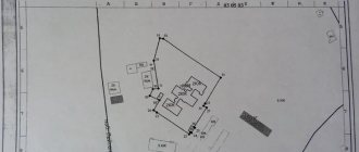
- The engineer makes a geodetic survey of the land plot on the ground, determines the coordinates and prepares drawings.
- The layout of the land plot is agreed upon with the owners of adjacent plots.
- The cadastral specialist prepares a boundary plan that will be used for cadastral registration of the land plot. If a house is built on the land, then for its subsequent registration, a technical plan of the site is also immediately drawn up.
- The owner or his authorized representative submits a package of documents for state registration. Registration of a land plot for cadastral registration is not subject to state duty, unlike registration of rights to an object.
- After the expiration of the established registration period (up to 12 days), the owner receives an extract from the Unified State Register of Real Estate about the main characteristics and registered rights. The extract will contain information about cadastral registration, including a plan of the land plot. In addition, after a month or two, the plot of land itself appears on the public cadastral map of Rosreestr with delineated boundaries. Cadastral passports will not be issued since 2021.
Terms and cost of services
How long does it take to register a house in the cadastre? The timing of the procedure is specified in Art. 16 of Law No. 218-FZ. When submitting documentation to the MFC, all accounting actions will be completed within 7 working days. Contacting Rosreestr directly will speed up the procedure by up to 5 working days. There are no fees for urgent registration.
Although there is no state duty for registering a house or other object, the costs may include:
- payment for cadastral works, production of technical plans, boundary plans;
- payment for the project and other documents to change the characteristics of the building or premises;
- payment for support services for accounting and registration of transactions.
The exact cost of the service and documents can be determined after analyzing the features of the object. You can see preliminary prices in the table below.
| No. | Basic concepts you need to know to register a building with cadastral registration | Description |
| 1 | Commissioning | A procedure confirming the completion of construction work on the project and the readiness of the facility for operation. For apartment buildings and non-residential buildings, upon commissioning, a permit from the State Construction Supervision Authority is issued. For private households, a notification is issued through the local administration. |
| 2 | Technical plan | The main document on the basis of which the object is placed on cadastral registration with information entered into the Unified State Register of Real Estate. The technical plan is prepared by a cadastral engineer after examining the building. |
| 3 | Cadastral engineer | A professional specialist who has the right to draw up a boundary or technical plan, an inspection report for objects. A cadastral engineer must have a qualification certificate. Information about all engineers is in the Rosreestr database. |
| 4 | Registration of rights | The procedure during which Rosreestr enters information about the copyright holder of an object into the Unified State Register of Real Estate. Registration can be carried out simultaneously with cadastral registration, or separately from it. |
| 5 | Cadastral registration in case of changes in the object. | The procedure during which data is entered into the Unified State Register of Real Estate after reconstruction or redevelopment of an object. For cadastral registration of changes, you need to draw up a technical plan and contact Rosreestr. |
How to choose a specialist to register a land plot with cadastral registration
Preparing documents for registration of a land plot is a rather expensive procedure; the cost depends on the region and the complexity of the work. The price starts from 10-15 thousand rubles and tends to one hundred thousand. The owner of a land plot does not have the right to independently carry out the necessary work and is forced to turn to specialized organizations or certified specialists.
When choosing an engineer or a specialized bureau, you need to focus primarily on the availability of the necessary qualifications and approvals, and only then discuss the cost of services. A cadastral engineer's mistake can be costly for the site owner.
The specialist must pass a qualification exam, have membership in an SRO and, preferably, professional experience. You can check a cadastral engineer for free on the Rosreestr website in the “Services – Register of Cadastral Engineers” section.
Suspension of land cadastral registration
In some cases, cadastral registration of a site may be suspended for a number of reasons, including:
- receipt of objections from the owners of the plot from which individual shares are being allocated (if the matter concerns agricultural territories, in accordance with the Federal Law “On the Turnover of Agricultural Land” dated July 24, 2002 No. 101-FZ);
- violation of established legal procedures for the approval of plot boundaries;
- lack of passage (passage) to the newly formed territory (including when granting easement rights);
- changing the actual boundaries of the allocated area, except for cases of their clarification;
- expiration of a previously approved plan or scheme of the territory (in the event that registration is carried out in accordance with this plan or scheme, in accordance with No. 218-FZ);
- excess of the area of the land plot after clarification of its boundaries relative to the previously declared area.
Where to get documents for registering a plot of land for cadastral registration
Any process of preparing a package of documents for land begins with receiving a current extract from the Unified State Register of Real Estate, which contains information about the main parameters and ownership of the site, which are contained in the Rosreestr databases.
Official extracts from the USRN, certified with an electronic digital signature, are provided by the online service USRN.Reestr. Such statements are accepted by any institution, including Rosreestr, banks and courts. The document can be printed or used electronically.
Often, for land plots acquired several years ago, the owner or heir cannot find the document that provides the basis for obtaining rights to the land. Using an extract from the Unified State Register of Real Estate, you can clarify on what basis this land was received and find it or request a duplicate.
The land survey plan is prepared by a cadastral engineer and must be submitted electronically.
When and why is the service required?
The procedure for registering a land plot for cadastral registration is regulated by the Federal Law “On Cadastral Activities” dated July 24, 2007 No. 221-FZ. It is required by the owner(s) of the site when:
- registration of ownership of it;
- making a sale or other transactions;
- using the land as collateral when obtaining a loan;
- participation in legal proceedings where the subject of the dispute is the plot in whole or in part;
- receiving compensation (in the event that the territory is alienated in favor of the state).
We have registered the land in the cadastral register - what next?
Now registration in the land cadastre and registration of rights to a plot occur simultaneously.
After receiving an extract from the Unified State Register of Real Estate about the completion of state registration of cadastral changes, you can perform any actions with the land plot - sell, donate, inherit, and so on.
In the future, any changes in the technical characteristics of a plot of land will also need to be registered in the cadastre:
- changes in boundaries or area;
- division or combination of plots;
- erection or demolition of buildings, as well as changes in their area;
- changing the category of land, etc.
To prepare the documents, you will again have to involve a cadastral engineer, who will prepare a new cadastral plan (and, if necessary, a technical plan) taking into account the changed characteristics of the object.
What is land overlay and how to fix it
Despite modern technical measurement devices used in cadastral registration, in practice situations arise in which land plots overlap or inaccurate data is entered into the Unified State Register. Object overlap represents the mismatch and intersection of the boundaries of registered objects.
If the boundaries of your plot are incorrect and as a result it overlaps with another, contact a cadastral engineer and carry out work to clarify the boundaries. He will draw up a boundary plan, in which he will indicate that it has been prepared in connection with the correction of the error. After this, you should contact Rosreestr with an application for cadastral registration in connection with a change in the description of the boundaries of the object. The application is accompanied by a boundary plan, drawn up with amendments. The error will be corrected by clarifying the boundaries of the property. Based on the results of consideration of the application, Rosreestr will make a decision on making changes.
If the boundaries of a neighboring plot are incorrect and its owner does not agree to a voluntary change in the contour, the dispute will have to be resolved in court. The court decision is the basis on which the cadastral error will be corrected; Judicial practice does not establish the facts of violation of the rights of the plaintiff as a basis for the imposition of land plots. This position is established by the Ruling of the Supreme Court of the Russian Federation dated December 16, 2014 No. 18-KG14-159 - the mere fact of overlapping the boundaries of the defendant’s land plot with the boundaries of the plaintiff’s land plot does not prove a violation of the latter’s rights.
How to submit documents
The processes of cadastral registration and registration of property rights are now concentrated in the hands of Rosreestr. Therefore, you can undergo both procedures at once in one organ - this is convenient.
Even more pleasantly, there are several options for interacting with Rosreestr; it is not at all necessary to even personally visit this institution. If all the necessary documents are ready, then you can register the land plot with the cadastral register:
- in person - for this you need to submit a set of paper documents directly to Rosreestr or through the MFC or;
- by mail - send a package of documents to Rosreestr by registered mail with acknowledgment of receipt and a list of the contents;
- via the Internet - send electronic documents through the Gosuslugi portal or directly send them to Rosreestr. This will require an enhanced qualified digital signature.
Text: Natalya Petrakova
What is it and how is it regulated by law?
Reference. Registration of a land plot for cadastral registration is a set of procedures carried out by an authorized body.
It may consist in the establishment, termination or change of data about the site, reflected in the information base of the real estate cadastre. That is, registering a land plot implies entering information about the site into the cadastre. Without this procedure, it is impossible to sell, exchange or rent out such real estate; it makes its owner not only a full owner, but also allows him to dispose of the site at his own will.
Mandatory rules for the accounting in question for the memory company in accordance with the law are in effect from January 1, 2021.
Registration of a plot for cadastral registration is regulated by Federal Law No. 218, which contains all the documents on the basis of which the registration process is carried out, in what cases and under what conditions.
If the plot was owned before the adoption of the law and is not currently registered in the cadastral register, then this does not deprive the owner of ownership rights and no one will be able to challenge it, but when selling or other actions with the land plot, registration will have to be carried out without fail.
Let's sum it up
You can register a site as previously registered yourself, without ordering boundary plans, diagrams or the services of representatives. To do this, you need to contact the MFC with land allotment documents and submit a corresponding application.
If there are no legal documents to register the object, additional measures will be required to approve the location plan by the authorized body, as well as to prepare a boundary plan for the formation of the land. In this case, a plot of land can be acquired either for ransom or for free, depending on whether a building is registered on the plot and in what year the right to it was acquired.
The result of registration will be an extract from the Unified State Register.
Read: How to properly survey a plot of land in SNT and is it necessary to do so?
Previously registered areas
Previously registered land plots include those objects the rights to which arose before the entry into force of the law on the cadastre, that is, before March 1, 2008 (No. 221-FZ of July 24, 2007).
Therefore, if you have been using the site for a long time and you have land allotment or legal documents for it, you can enter information into the Unified State Register of Real Estate for free upon your application.
What documents are the basis for registering land in Rosreestr without surveying:
- Certificates of ownership or government documents establishing the right of a specific citizen to use the site. Land can be provided on the basis of ownership, perpetual use, or lifelong inheritable possession.
- Decision of the authorized body to provide the site.
- Extract from the household register about the availability of rights.
- Development agreement.
- Court decision and other documents issued before the entry into force of the law on registration of rights to real estate, until January 31, 1998.
To register a plot as previously registered, you need to:
- Contact the MFC with documents for the land.
- Submit an application to Rosreestr. The form itself is filled out by an MFC employee. The service is free, applications are accepted from any person, not only from the owners of the site.
- After 5-10 days, you will receive an extract from the Unified State Register at the MFC.
The extract will contain minimal information: area, category and purpose (if information about this is in the source document), cadastral value, date of registration, address. The plot will be assigned a unique cadastral number, which will mean that it is contained in the Unified State Register of Real Estate. Special notes will indicate that the boundaries have not been specified in accordance with the law.
The right is not registered during this procedure. However, using a land allotment document, it is most often possible to register ownership without interference. Once the land has a cadastral number, the owner can apply to acquire ownership rights.
After receiving the cadastral number, you can carry out further necessary actions:
- Register the right.
- Specify boundaries and area (landmarking).
You can submit an application to enter information into the Unified State Register of Real Estate without documents.
Rosreestr itself will request the necessary data in the manner of interdepartmental interaction with other government agencies. If the documents according to which the land was provided are available in the archives of the local government, then information about the site will be entered into the register. The only thing is that such an application will take longer to consider than if there are supporting documents. If land users have never had the necessary documents, and, accordingly, rights, then it is impossible to enter information into the Unified State Register of Real Estate and register ownership of the land in such a simple way.
When there is no ownership of the land being used
There is a different procedure for obtaining a cadastral number in the event that there are no grounds for registering land for a specific person.
In each case, privatization will occur differently, depending on the documents, the presence or absence of registered buildings on the land, etc.
The issue of privatization of a land plot should be approached individually; consultation with a lawyer or cadastral engineer is required.
How to form a land plot if there are no documents for it:
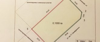
- Prepare a diagram of the location of the site in the cadastral quarter. It depicts the boundaries of the site and the coordinates of its turning points. To determine the exact location of the boundaries, you will need to involve a cadastral engineer.
- The scheme is submitted to the local government for approval.
- If the administration agrees with the provision of the site, it issues an order. The land can be transferred to the owner of the building either free of charge or for a fee. If the right to homeownership appeared before October 30, 2001, it is free.
- Based on this order, the cadastral engineer prepares a boundary plan for the formation of the site.
- The boundary plan is submitted to the MFC to assign a cadastral number to the land plot and register the right to it.
When, according to the Land Code of the Russian Federation, the preparation of a scheme for the formation of a site is not allowed:
- If the plot is in gardening partnerships.
- When the land is formed under an apartment building.
- When forming an object in a garage cooperative.
In these cases, plots can be formed only in accordance with the approved planning and surveying project. This is an expensive and large project for an entire block, which a private individual cannot order.