In the USSR, land rights of citizens, as such, did not exist due to the fact that all land was owned by the state. Therefore, in modern Russia it “swinged” for several decades. And now more and more owners of suburban real estate are asking the question: “How to properly prepare documents for land surveying and go through the procedure?”
The interest is explained by the fact that in less than a year, without land surveying, any operations with land plots will become impossible (including gratuitous ones, such as kinship donation/inheritance).
Simply put, mandatory land surveying in Russia is becoming a legal norm. Since the procedure, to put it mildly, is not the easiest and fastest, people try to carry it out in advance so that it does not subsequently slow down a possible deal. Moreover, as part of the “dacha amnesty” you can still do this for free.
If we describe the actions of the landowner in this direction briefly/simplified, we get something like this:
- Collect documents necessary for land surveying
- Find a qualified and conscientious cadastral engineer
- Conclude an agreement with him and make sure that its terms are met
- Get your hands on a cadastral plan
Later in the article we will create a more detailed step-by-step plan containing useful tips for each stage.
Why is this procedure needed and what does it mean?
Any real estate property is subject to inclusion in the Unified State Register of Real Estate. Real estate, excluding premises in apartment buildings, must be “connected to the locality.” This “binding” is the land surveying in 2021.
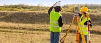
A specialist with the necessary qualifications secures the actual boundaries of the land plot. That is, using GPS, it determines the coordinates of turning points (corners) and, using a special program, forms a section of area, configuration, and location on a topographic map. Then the boundary plan is entered into the Rosreestr cadastre.
ATTENTION! In everyday life, people often confuse the demarcation of the boundaries of a land plot and the removal of its boundaries in nature. Meanwhile, these are different actions, directly opposite in purpose. Land surveying is the recording of an actually existing site and the drawing up of a topographic plan. Using the placement of points, you can check whether the actual plot corresponds to the cadastral plan. In this case, a plan is not drawn up; it is not needed. But this process makes it possible to resolve disputes between neighbors, for example, to check whether, by law, the fence between plots is where it is, or whether one of them has appropriated a piece of someone else’s land.
Only owned land can be demarcated (rented land cannot). The procedure should be carried out if transactions are carried out with the plot, as well as if they are divided or combined.
Are SNT obligated to demarcate PDOs?
Carrying out cadastral work to clarify the boundaries of land plots on the territory of SNT is mandatory. However, this is only relevant in a number of cases:
- It is planned to conclude a transaction with land - purchase and sale, will, etc.;
- Proceedings in which it is necessary to provide proof of rights to the site;
- There is a need to unite or divide the territory;
- A plot of land in a particular SNT is of high value;
- The owner needs to determine the exact area of his plot;
- Correction of errors in cadastral registers is required.
The management of SNT does not have the legal right to independently initiate measures to survey the territory. All land is not the property of gardening, so nothing will happen without the consent of the owners to the procedure. However, it is in the interests of land owners to entrust land surveying to the management of the partnership.
The owner will receive a lot of restrictions on the disposal of property if the site is not demarcated. The land plot cannot be sold, donated, etc. Regarding territories that are considered common, demarcation can only occur if there is the consent of the majority of owners of plots in the SNT.
How is the procedure for land surveying regulated by law?
Until the beginning of 2021, Russian citizens can legalize their suburban plots in a simplified manner. This point is reflected in Federal Law No. 171 of 2014. In common parlance, this legislative act is called the “dacha amnesty.” Its effect was extended several times. It allows for free land surveying until the end of the current year.
According to Federal Law No. 218 of 2015, it is possible not to survey certain types of plots for sale, donation, or inheritance. This clause expires approximately at the same time as the “dacha amnesty”. Unless, of course, new legislative changes occur within a year, which is, in principle, possible.
However, it is more reasonable to consider that the period of validity of land surveying (or rather, the right to own land without carrying out this procedure) is coming to an end, and everything must be done on time.
The cadastral registration procedure itself is regulated by Federal Law No. 221. It will also be useful for the landowner to know and understand the main provisions of the Land Code of the Russian Federation.
Legislative regulation of the issue
After a detailed study of this issue, we can conclude that this procedure in relation to the dacha area is quite a serious and relatively mandatory step to implement.
legislative acts make this process “mandatory” and desirable for implementation :
- Article 218 of the Federal Law (this act describes the procedure for registering real estate);
- Article 221 of the Federal Law (this document includes the procedure for cadastral registration of so-called isolated territories);
- A manual printed by Roszemkadastr (in the form of a small book, it contains all the necessary information about the procedure and principles of land surveying of a summer cottage).
Step-by-step procedure for marking the boundaries of a land plot
The landowner will need only four steps:
The first step is to collect and prepare all the documents necessary for land surveying.
The first owners of land, participants in its distribution, need:
- Resolutions of local authorities on the basis of which land is allocated
- Map of the site on the general cadastral plan of the territory
If the allotment has already been registered in your name, you only need an extract from the Unified State Register of Real Estate. The delivery time for a regular order is 3 days. By contacting the Rosreestr API website directly, a document can be issued in electronic form in an hour. The price of receipt and validity will be similar.
In other words, if you have to survey a plot of land, what documents will be required depends on whether you actually own it or not.
The second step is to find a cadastral engineer
The most reliable selection criterion, as at all times, is the personal recommendation of people you know. Or go to the Rosrestr website, there is a special service there.
Engineers who have confirmed the appropriate qualifications are united in SRO, information about each is available. Read the reviews and pay attention to how many and whether all surveys carried out by the specialist were successfully registered with the state.
Then draw up and sign the contract. Independent experts set the cost of land surveying themselves. Practical statistics by region indicate that the price for land surveying can vary by two to three times.
In the Moscow region the range is from 10 to 30 thousand rubles.
In the Leningrad region - from seven to fifteen.
In most other regions it starts from five. Be sure to keep receipts/receipts indicating that the service has been paid for.
The third step is to sign the work completion certificate and receive the documents in hand.
In principle, the procedure for land surveying does not require your personal presence. You can simply order the service, and then receive from a specialist a “land survey file”, consisting of a cadastral, boundary, and technical plan (if there is a house on the site). Nowadays, documents are issued on a CD. But if you need a “paper” version (for example, for court proceedings), they can also prepare it.
Upon receipt of the documents, an act of acceptance of work is signed. As usual - in two copies. Sign it only after checking the documents. And keep “your” copy just in case.
The fourth step is to make sure that the result of the survey is in Rosreestr
Typically, the customer receives documents in hand from the cadastral engineer within two weeks after signing the contract. From this day, another 5-7 days may pass before the information is published on the Rosreestr map. After they pass, go to the map website. If you find your plot there, the job can be considered done.
Requirements for the content of the contract
When drawing up an agreement between the customer and the surveying organization, it is necessary to pay attention to its content. The obligatory clauses of the contract are:
- personal data of the customer;
- name of the organization and details of its statutory documents;
- types and volumes of work that the organization must perform;
- list of rights and obligations of the customer and contractor;
- cost of services provided and payment procedure;
- start and end dates of work;
- a description of the responsibility of the customer and the contractor in the event of situations related to claims, risks, penalties or damage caused;
- Details and signatures of the customer and contractor.
Sample agreement on land surveying
The following documents are drawn up as an appendix to the main agreement:
- those. exercise;
- step-by-step work schedule indicating deadlines.
The terms of reference indicate information about what work the cadastral engineer must perform. Approximate contents of the technical specifications:
- description of the object indicating the exact address, cadastral number, area and intended purpose;
- detailed listing and description of the work performed;
- the obligation of the executor to draw up the plan on paper;
- the engineer’s obligation to carry out work in accordance with SNiP (they must be listed and have a detailed description);
- description of the final result that the customer will receive.
Results of cadastral work
In the step-by-step schedule, it is necessary to indicate the deadline for completing each of the stages and their content:
- the preparation stage, which includes the collection and analysis of documentation;
- stage of land surveying;
- the stage of registering land with Rosreestr and obtaining a cadastral passport.
The contract is considered fulfilled after the bilateral signing of the work completion certificate, indicating the names and terms of the work performed, as well as any existing claims.
The following documents will be required on the part of the customer:
- original passport;
- original certificate of ownership and grounds for ownership;
- original power of attorney, certified by a notary, if a proxy acts on behalf of the applicant;
- a certificate from the electrical network company confirming that there are no electrical cables on the site;
- a certificate from the administration of the municipality about the absence of public utilities on the territory of the site.
Important! Certificates are issued immediately at the time of application, but if the requested information is not available, representatives of the power grid company or administration go to the site to record the necessary data.
The procedure for approving the boundaries of a land plot - surveying or removing points
If your plot is not located in an “open field”, you will need to agree on land surveying with your neighbors. They (plus the Chairman of the Board, if you have a plot in a garden/dacha association) will have to confirm in writing that they agree with the boundaries of the plot. You must notify the neighbors/chairman yourself.
Therefore, although we wrote that the presence of the owner of the property during the procedure is not required, it may be better for you to come to the place. After all, the neighbors/chairman must be there to sign the appropriate signatures. To avoid misunderstandings, it is better to check everything yourself.
“Territorial disputes” with neighbors must be resolved in advance. If this is not possible, record the fact of refusal in writing, look for all old documents indicating your right to the disputed “pieces,” hire an experienced lawyer and go to court. This is a long and expensive business.
Therefore, if we are talking about a couple of really controversial square meters, sometimes it is preferable to give in in order to save yourself from unnecessary hassle and costs. If the neighbor has “completely lost his conscience” - sue.
Judicial practice is optimistic - most of the justified claims of the plaintiffs are satisfied.
Price
Land surveying services are not cheap for the site owner. Prices vary greatly depending on :
- region;
- squares;
- outlines of the site;
- distance from the city.
On average, the price for the services of a cadastral engineer to survey a garden plot of 6 acres will cost 10 thousand rubles . If the configuration of the plot is correct, the plot is located within the city, then the price can be about 5 thousand .
But pensioners often do not have even this amount. Therefore, you need to approach the issue of land surveying rationally. If you have received a cadastral passport and registered ownership of the garden plot, then you can sell your plot without land surveying. Another question is whether it will be in demand.
However, on various Internet platforms, rumors are now persistently spreading about mandatory land surveying and the absence of deferment, as evidence of which Federal Law No. 477 is cited. This law is presented incorrectly; it refers to changes in the Tax Code, and not the state cadastre.
The news is also erroneous; there is no article in the legislation obliging the determination of the boundaries of the site.
Is it possible not to pay for the procedure?
In the step-by-step instructions, we have already touched on the question of how much land surveying costs. Is it possible to do this for free?
It is possible, but only at a time when the municipality is carrying out comprehensive cadastral work. Information about them should be found on the official websites of local authorities.
If such work is underway or planned, an application must be submitted. Its form is free, you just need to indicate your full name, passport details, location, cadastral number of the plot. The right to use cadastral work free of charge gives:
- "Dacha amnesty"
- Registration of a plot before 1998 (if it is not included in the Unified State Register of Real Estate)
- Recorded cadastral errors made earlier
- Lack of registration with Rosreestr of the allotment, data about which this organization has
If you need to sell your cottage
It was indicated that when purchasing/selling a dacha, problems may arise due to the lack of a boundary plan. But these are just conventions.
Before January 1, 2021, you can sell real estate if, for example, the buyer himself does not mind the fact that you will not be able to provide him with a document about the land survey carried out earlier on the site. But next year such a procedure cannot be avoided, since the state has decided to block citizens from taking any legally significant actions in relation to their summer cottages if they do not have boundary plans.
Is it possible to challenge the land survey of your own or a neighboring plot?
Of course you can, if there is a legal basis. You just have to follow a certain sequence of actions:
- First of all, file a complaint with your local administration.
- If the administration is inactive, get a written refusal from the officials to satisfy your material rights and contact the Prosecutor’s Office
- If the Prosecutor’s Office also receives a refusal to file a complaint, file a statement of claim with the court.
Trial proceedings require careful preparation. We recommend using the assistance of experienced land law lawyers.
Initial free consultations are available on the prav.io website. possible at any time of the day.
A lawyer found on the site can also help in preparing the necessary documents (including the claim itself). And if he lives in the same city with you, he can undertake representation in court and full protection of your rights.
Process of registration of the act
When drawing up a document, the presence of all involved persons is necessary, so in order to save time, you can hold a meeting with everyone at once. To do this, no later than a month before the expected date, each participant must be notified against signature. If it is not possible to gather everyone at the same time, you can discuss and negotiate with each interested participant separately.
If it was not possible to get in touch with all interested parties, then through the media you need to publish an announcement about the meeting, indicating the exact date of its holding, time, place, contact information of the customer and performer of the work, as well as cadastral registration numbers of the territories.
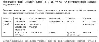
Filling out the report is the responsibility of the engineer. The document must contain the following information:
- personal data of each of the interested parties (or their representative by proxy);
- the result of the agreement;
- schematic representation of boundaries;
- objections and comments expressed by the approval participants;
- personal signature and seal of the cadastral engineer;
- personal signatures of each participant or representative.
Important! If there are discrepancies between the parties, they must be indicated in the act, supported by supporting documentation. Then, in court, demand that the act be declared invalid. In this case, the court orders a new survey.
Installation of boundary signs
As soon as the boundaries are agreed upon by all interested parties, boundary signs are installed on the site. They are made of wood or metal and have a plate indicating the date of bookmark and number.
Rules for installing signs
The main requirement for a boundary post is the use of indelible paint to indicate data. In case of damage, administrative liability and penalties are provided.