The owner can dispose of his own land without restrictions only after registration of rights.
Thanks to the preparation of documentation, he can protect his interests and own the site in full.
To apply to Rosreestr, the owner must prepare a package of documents regulated by legislative acts.
We will discuss the list of documents that are required in various situations, for example, when entering into an inheritance, transferring from rent to ownership and for preferential registration.
What papers are needed to register ownership of a land plot?
The procedure for state registration of rights to real estate occurs on the basis of many legislative acts, which received significant changes in 2021.
In particular, changes were made to such laws as:
- Federal Law-218 “On State Registration of Real Estate”;
- Federal Law-280 on determining the category of land;
- Federal Law No. 274 dated July 29, 2017 “On valuation activities in the Russian Federation”, regulating the cadastral value of land;
- Changes have been made to the classification of types of permitted use of sites.
Since 2021, new formats of technical plans have been used and new rules for the formation of land plots and determination of boundaries are in effect.
Based on everything,
the following basic papers are needed to register land:
- Application for registration of rights. It must contain a link to a regulatory act of the Russian Federation that ensures the right of the owner of the plot to apply for registration.
- Identity card confirming citizenship.
- Legal documentation. These may include:
- acts issued by local authorities for the transfer of the site into the ownership of the applicant;
- contract of sale, exchange, lease;
- protocol of SNT or other organization that transferred the land area for use;
- an act indicating the commissioning of a construction project;
- gift agreement, will;
- court and settlement decisions;
- others indicating the option of receiving an allotment.
- Cadastral plan of the site. You can request a plan from the Cadastral Chamber; if land surveying has not been carried out before, the owner must go through the entire procedure independently.
- Title documents for objects located on the site according to the cadastral plan.
- Receipt for payment of state duty.
Important! If cadastral work was previously carried out and there is a land survey, but according to the new measurements, inconsistencies have arisen, you will have to justify the difference.
Additionally, a privatization act is required if this action was carried out by the previous owner.
If the plot was purchased from the administration, a receipt confirming the deposit of funds into the account is required.
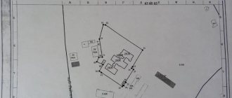
Carrying out topographic survey of the site and its surveying
Controversial situations often arise when determining the boundaries of a plot of land . This problem is especially relevant for summer residents.
To resolve a controversial situation, land surveying is carried out. Most often, land surveying is used to determine the boundaries of new areas.
This procedure is a certain set of works, including establishing, securing, and, if necessary, restoring the boundaries of a land plot.
In addition, land surveying helps to legitimize the actually used area of the land plot. In this case, when carrying out this procedure, the actual area of the site is indicated, and not stated in the documents.
Such an increase in land is possible only in agreement with neighbors and within the limits established by local governments (in practice, an increase in area is allowed by no more than 10% , or up to six hundred square meters ).
Land surveying is also necessary in the case of dividing one plot into two or more and in the case of merging (purchasing) adjacent plots of land.
In many cases, the need for land surveying is due to a more serious problem. Often, old title documents for land do not indicate clear boundaries of the plot, but only its exact size.
In this situation, the owner cannot prove his rights to the occupied land. If a controversial situation arises, he can, perhaps, provide the judicial authorities with a topographical survey of the site along its borders.
Topographic survey is a set of activities aimed at measuring the earth's surface and drawing up a map of a site or area.
Topographic survey of the site is necessary for the following purposes:
- development of a territory planning project;
- purchase (lease, privatization) of a site;
- gas pipeline laying.
The following objects are displayed on the land survey plan:
- buildings (including structures, structures);
- fencing;
- roads;
- communications;
- vegetation.
If land surveying was not carried out on the land as part of the pre-sale preparation, then not a single transaction with it will be registered with government agencies.
In this case, a corresponding entry is made in the cadastral passport about the owner’s refusal to carry out land surveying .
Land surveying and topographic surveys are carried out by geodetic companies.
For preferential land registration
Categories of citizens officially included in the standard preferential list are entitled to receive preferential registration of a plot of land.
Each group has its own reasons for preferential conditions, which should be confirmed by the appropriate document.
In addition to the standard list discussed above, the kit has the following composition:
- marriage certificate;
- child's birth certificate;
- extract from the Unified State Register of Real Estate;
- ID, certificate indicating membership in a preferential category.
After preparing the package, you should draw up an application for registration of property rights.
Attention! A plot of land is issued on a preferential basis with subsequent registration of ownership. The time from the application period to the receipt of land rights can be long, since the applicant is placed in a queue of preferential categories.
If a family uses a plot of land and builds real estate on it, documentation on the objects should be prepared.
Sanctions for illegal land seizure
Cases of illegal seizure of land are established by Art. 7.1 Code of Administrative Offences.
If fraudulent aspects are identified, the case may fall under the criminal code. With this option, the offense faces much more serious consequences than just a fine and seizure of the site.
In the absence of fraudulent activity, the violator will most likely pay a fine. Its size depends on several factors:
- whether the plot is registered in the cadastral register;
- What is the estimated value of this plot of land?
What do you need to collect if you inherited land?
For the transferred land on the basis of a will, you must open an inheritance case with a notary within 6 months and obtain a certificate of inheritance.
There may be several heirs, then each will own a certain share of the inheritance. If among them there is a person with preferential rights, the rest will receive compensation for their part.
After completing the necessary procedure with a notary, the heir must register his ownership rights to the received property.
To do this, he contacts Rosreestr with a standard package, to which he adds:
- certificate of inheritance;
- death certificate of the testator;
- a will, as a document of title;
- an act drawn up by an independent appraiser on the market value of the property;
- a certificate confirming the absence of buildings;
- extract from the Unified State Register of Real Estate;
- a certificate of the place of registration of the deceased;
- if the land is part of SNT, the charter of the company.
After checking the package of documents, the registrar will issue a receipt confirming its acceptance and inform you of the date of the visit to receive an extract on the changes.
Increasing the area of land - is it free or for money?
There is an opinion that increasing the land plot can be done completely free of charge, but this is not so. It is only possible to obtain the adjacent lands for free, that is, they do not need to be purchased from the state, and the very registration of the new formation in the form of an enlarged land plot after the addition is a procedure that requires monetary costs.
Indeed, in order to document newly created possessions, it is necessary to prepare a boundary plan. To do this, we enter into an agreement with a cadastral engineer, naturally on a paid basis.
The newly created site must be coordinated and a ready package of documents must be submitted for registration to the MFC. All this time and money, but as a result you will receive a legally registered plot with an increased area.
Expert opinion
Borisov Georgy Mikhailovich
Lawyer with 10 years of experience. Specializes in criminal law. Law teacher.
You can find out the cost of the boundary plan using a free service on the website - an online calculator for cadastral works; we also suggest that you familiarize yourself with the catalog of companies in your region that provide cadastre services on the website.
How to register and what to prepare if you need to transfer from rent to ownership?
If the land has been transferred to use on the basis of a lease agreement or an indefinite lease agreement , the following should be attached to the main package:
- permission from a local government committee, issued in accordance with a citizen’s application, for the allocation of a site;
- act of acceptance and transfer of an object;
- technical documentation issued by BTI;
- geodetic, general, boundary plan.
For privatized land, you should request an extract from the cadastral authority.
For buildings on the land plot there must be documents indicating ownership . The plot may be transferred to the applicant on a paid or free basis.
In the case of a gratuitous transfer, a written decision will be issued to the administration, and in the case of a paid transfer, a purchase and sale agreement will be drawn up.
Reference! This document is also submitted to Rosreestr.
What cannot be legalized?
A person can in fact use the land for a long time, and the addition complies with the law. However, there remains the risk that such additions will be refused. But there are categories of land that are simply impossible to register as private property:
- If the land belongs to a specially protected area, to forest fund lands.
- If the water body, located in municipal or federal ownership, is located exactly on the disputed site.
- Lands issued for communications or transport services.
- Plots located near lands required for state needs.
- Weavings that are adjacent to the zones of sanitary protection of water resources, to the coastline.
It often happens in practice that registration of extra acres is denied, because they are part of the forest fund. Accordingly, it will not be possible to register them. But you can arrange a lease. To understand what opportunities are open, you can sign up for a consultation with an expert from our company.
List of papers, if you need to fill out the dacha amnesty
Today, a dacha amnesty is still in force, ensuring the right to register land plots according to a simplified scheme. Its basis is the registration of property rights without a boundary plan (data is entered into registration acts without establishing boundaries).
The following are entitled to simplified registration:
- participants in gardening partnerships, persons who received land for gardening, growing vegetables, farming and building residential premises;
- owners of real estate located on a site without established boundaries;
- owning an object on the basis of a contract of perpetual use or lease.
In this case, there is no need to create a cadastral plan. If the property is owned, an extract from the Unified State Register is required.
Documentation certifying the right to registration may include:
- a book of a member of SNT, GSK, a certificate from the chairman of the company about the transfer of the area to a citizen for use and payment of membership fees;
- an act on the transfer of land for use drawn up by the administration;
- early certificate of ownership;
- various extracts from government acts on the transfer of land for use.
Important! If the documentation is lost, you should contact the administration or management authorities to obtain an extract or certificates from the BTI.
Terms and cost of registration
Registration of a land plot is a lengthy procedure, since for this it is first necessary to survey the site and obtain a cadastral plan.
If all the necessary documents are ready for state registration, then the procedure itself will take only 7 working days .
When submitting documents for state registration to the Cadastral Chamber, the amount of state duty does not exceed 1,000 rubles for individuals and 15,000 rubles for organizations.
What is a garden plot
This is a plot of land that is classified as an agricultural area and is intended for gardening. On such a site you can build a permanent residential building and register it if the property is registered.
Most garden plots are part of SNT - a garden non-profit partnership. Such plots belong to municipalities and are allocated to citizens on the following basis:
- Long-term rental;
- Perpetual inheritable ownership;
- Indefinite use.
How to get a?
Because Currently, certificates are not issued, then an application must be submitted to receive an extract from the Unified State Register of Real Estate. To obtain it, you must contact the Rosreestr branch at the location of the land plot.
Procedure:
- Submitting a request and documents to Rosreestr or MFC. Submitted in person, in the form of an electronic application or through the State Services portal.
- Payment of the state fee.
- Waiting for the request to be processed.
- Receipt of the finished document.
Issued to individuals and legal entities.
Who issues the extract?
There are several ways to obtain an extract - a personal visit to Rosreestr or the Multifunctional Center , contact via mail, online registration.
When visiting one of the services in person, you must fill out an application and attach the required documents.
During the application, the applicant must indicate the cadastral number of the land. When ordering via mail, a citizen sends a registered letter with notification of its receipt.
You can also order an extract online – through the State Services website . Before submitting an application, you must register on the site and create a personal account.
Fill out the application in the appropriate section. After submitting your request, you will receive an email notification about the status of the document. You can pick up the extract at the Rosreestr branch.
Important! If the document will be collected by the applicant’s authorized representative, this fact should be indicated in the request sent.
Required papers and fees
To receive it, you must prepare an application for the service, as well as attach a passport and a receipt for payment for Rosreestr services.
If a document is obtained during the re-registration of rights, and an extract is issued at the end of the procedure, the package is supplemented with a set of documents necessary during the registration of the transaction (for example, a purchase and sale agreement).
The application will not be considered without paying the state fee. Its size depends on the form of provision and the volume of requested data.
For a paper version of the extract, you will have to pay 400 rubles for individuals and 1100 for legal entities (without indicating the coordinates of the boundaries of the site). If coordinates are required, the amount is different - 750 rubles for individuals and 2200 for legal entities.
For the electronic statement form, the fee is lower: for individuals 250 rubles without indicating coordinates and 300 with indication, for legal entities - 600/700 rubles.
Reference! The issuance of an extract will be refused if the request is drawn up incorrectly; the applicant does not have the authority to submit an application. Rosreestr notifies you in writing of the reason for refusal.
Dates of issue
The time for issuing the document depends on the method of submitting the complete package:
- If you visit Rosreestr in person, the completed document will be issued in 3 days.
- Registration of an extract through the MFC or online will take up to 5 days.
- Electronic registration will take up to 3 days.
- When sending a request by mail, the deadlines increase due to the longer delivery of documents.
Where is land ownership registered?
This is done by a specially authorized government agency, whose competence is specified in Article 3 of the above-mentioned No. 218-FZ.
It has the right to carry out such actions in accordance with the instructions of the Government of the Russian Federation and is called Rosreestr, and its full name is the Federal Service for State Registration, Cadastre and Cartography (Presidential Decree No. 1847 about this). In every city in Russia there is more than one branch of Rosreestr, where future owners of land plots should contact. It is worth noting that you need to submit documents exactly to the department that is geographically located in the same municipality as the land plot (hereinafter referred to as the land plot).
Cost of resolving the issue of land cutting
This procedure is not completely free
As stated above, this procedure is not completely free. Therefore, let's talk about the cost of trimming.
If the site belongs to federal property, then the person making the cut must pay 15% of its cadastral value.
But this rule applies if the annexed territory in its area does not exceed 10% of the land to which it is annexed.
If the amount exceeds 10%, the citizen will have to pay the full cadastral value of the land.
Its amount can be found out from the cadastral documentation, and the names of the passport for the plot. The following situation concerns cases where the plots are state-owned or are not demarcated (there is no cadastral value). Such situations occur frequently.
In such a situation, the law says that the normative value of land is determined by municipal authorities. That is, in fact, each region sets its own price.
The last thing you need to pay attention to is that the law does not provide for the possibility of paying in installments or in installments. It follows from this that the registration of this procedure will begin only when the full cost of the site has been paid.
Declaration for buildings
It is provided for all buildings, such as a garden house and outbuildings - a garage, a bathhouse and other capital objects. According to Art. 17 of the Town Planning Code of the Russian Federation, simplified registration is allowed only for those objects for the construction of which a permit is not required. These include a country or garden house, a separate bathhouse, a sauna, and a garage.
If a permanent residential building is being built, a declaration alone will not be enough. Additionally, a permit is required, which is issued before the start of construction work. The declaration is drawn up by the owner and includes descriptions of existing outbuildings. The document is drawn up in 2 copies separately for each object. You can use the declaration form.
Laws
Previously there was Art. 33 of the Land Code (LC), which stated that the permissible sizes of plots intended for gardeners, farmers, livestock breeders or summer residents were established by the laws of the constituent entities of the Russian Federation. At the same time, the sizes of plots for individual housing construction and personal subsidiary plots (LPH) were determined by acts of local authorities. In order to simplify the regulation of rights and eliminate duplication, this article has now been removed.
At the same time, for areas for which there are town planning regulations, the permissible dimensions are given in these documents (clause 1 of Article 11.9 of the Land Code).
These regulations, along with the types of permitted uses, indicate the maximum permissible area of the site.
These town planning acts are municipal documents and are valid only in a certain territory.
In territories not related to the areas of application of these regulations, the size of plots will be determined according to the Land Code and other laws (clause 2 of Article 11.9 of the Land Code). The territories where there are no urban planning regulations, along with many other territories, include agricultural lands.
For such lands, the permissible plot sizes are regulated by the Land Code, as well as the law “On the turnover of agricultural lands” (No. 101-FZ of 2001) and the law “On private plots” (No. 112-FZ of 2003).