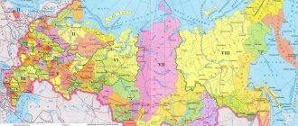
Zoning of territories of settlements is caused by the establishment of the order of land use. Therefore, the lands of settlements that are located within the administrative boundaries are divided into zones, taking into account urban planning requirements.
Dear readers! Our articles talk about typical ways to resolve legal issues, but each case is unique. If you want to find out how to solve your specific problem, please contact the online consultant form on the right. It's fast and free! Or call us at :
+7 Moscow, Moscow region
+7 St. Petersburg, Leningrad region
8 Federal number (free call for all regions of Russia)!
Territorial zoning of settlements
Land zoning is the division of the territory of a settlement into areas that have different purposes and the corresponding legal regime of use. Zoning is carried out in accordance with the approved plan for the development of the settlement.
The regulations on zoning and its basic principles have been approved by the Government of the Russian Federation. The decision to carry out zoning is made by an administrative document of a territorial government body or a decision of a local government body.
Residential zones include land plots that are intended for individual and public residential development, as well as the construction of cultural, social and social facilities.
Real estate located in a residential area can be represented by individual residential buildings, low-rise, mid-rise and high-rise buildings. In addition to residential buildings, other types of development may be located according to the urban planning plan.
Most of the territories of settlements are allocated for housing development, which corresponds to the intended purpose of the category of lands of settlements.
However, populated areas cannot exist without administrative buildings, educational, cultural, and social facilities. Therefore, such objects are also included in urban planning plans for the development of residential areas of settlements.
A certain part of the land in settlements is allocated for industrial development, utility and warehouse facilities, engineering and transport infrastructure. Such facilities have sanitary protection zones to ensure the safety of residents of the locality.
The improvement of such areas is carried out by the owners of production facilities at their own expense.
The legal regime of lands in settlements, which provides for urban zoning, is provided for by land and urban planning legislation.
Zoning of territories is a two-way process that provides for the planned use of land in a settlement through the adoption of regulatory documents at the level of local authorities.
Planning of territory development and establishment of land use rules is carried out for the following purposes:
- to create conditions for the sustainable development of the territorial municipality;
- preservation of the environment and objects that are classified as cultural heritage monuments;
- planning the boundaries of the administrative territory of a settlement;
- proper provision of the rights of owners of land plots and protection of their interests in the use of plots and buildings and structures located on them;
- creating a favorable investment climate by providing a wide choice in the use of allocated land, as well as objects related to capital construction.
Land use and development rules.
Read about conditionally permitted types of land use here.
How you can use the lands of settlements, read the link:
The rules for land use and development of the territory of a populated area, approved by the relevant body of state power or local self-government, provide for the procedure for their application and the introduction of appropriate changes to them.
An integral part of these standards are:
- urban zoning map;
- town planning regulations;
- regulations on regulation of land use and development by local governments;
- the procedure for changing the types of permitted use of land plots and capital construction projects;
- regulations for the preparation of territory planning documentation;
- the procedure for holding public and public hearings on issues related to the procedure for land use and land development;
- the procedure for making appropriate changes to land use rules.
Other issues that require consideration may also be included. Approved boundaries are drawn on the urban zoning map according to territorial zones.
Moreover, each land plot can belong to only one territorial zone, which is reflected in the corresponding boundaries.
It is impossible to form one land plot from several that are located in different territorial zones, since territorial zones are not established for one plot.
The urban planning map must reflect the zones whose boundaries relate to the territories in which cultural heritage sites are located.
ZOUIT - what is it and how can a land owner find out about existing restrictions
In 2008, the concept of “Zones with special conditions for the use of territories (ZOUIT)” was introduced into the Town Planning Code of the Russian Federation. And in 2018, a new Chapter XIX “Zones with special conditions for the use of territories” was introduced into the Land Code of the Russian Federation.
ZOUIT are installed for the following purposes:
1) protection of the life and health of citizens;
2) safe operation of transport, communications, energy facilities,
national defense and state security facilities;
3) ensuring the safety of cultural heritage sites;
4) environmental protection, including protection and preservation
natural healing resources, preventing pollution, clogging,
siltation of water bodies and depletion of their waters, preservation of habitat
aquatic biological resources and other animal and
flora;
5) ensuring the defense of the country and the security of the state.
Art. 105 of the Land Code of the Russian Federation establishes the following types of ZOUIT:
1) zones for the protection of cultural heritage sites;
2) protective zone of a cultural heritage site;
3) security zone of electric power facilities (power grid facilities
farms and facilities for the production of electrical energy);
4) railway security zone;
5) roadside strips of highways;
6) security zone of pipelines (gas pipelines, oil pipelines and
oil product pipelines, ammonia pipelines);
7) security zone of communication lines and structures;
 airfield area;
9) area of the protected object;
10) zone of a protected military facility, security zone of a military facility,
prohibited and special zones established in connection with the placement
specified objects;
11) protective zone of a specially protected natural area
(state nature reserve, national park,
natural park, natural monument);
12) security zone of stationary observation points
environment, its pollution;
13) water protection (fish protection) zone;
14) coastal protective strip;
15) district of sanitary (mountain sanitary) protection of health-improving areas, resorts and natural medicinal resources;
16) zones of sanitary protection of sources of drinking and domestic water supply, as well as those established in cases
provided for by the Water Code of the Russian Federation in relation to
underground water bodies of special protection zone;
17) flood and flood zones;
18) sanitary protection zone;
19) restricted area of the transmitting radio engineering facility,
being the object of capital construction;
20) security zone of points of the state geodetic network,
state leveling network and state gravimetric network;
21) observation zone;
22)security zone with a special legal regime;
23) fishery protection zone of Lake Baikal;
24) fishery reserve zone;
25) zone of minimum distances to highways or industrial
pipelines (gas pipelines, oil pipelines and oil product pipelines,
ammonia pipelines);
26) security zone of a hydropower facility;
27) security zone of metro infrastructure facilities;
28) security zone of heating networks.
All ZOUIT can be grouped into 2 blocks:
1) ZOOIT, which arose by virtue of federal law (water protection (fish protection) zones, coastal protective strips, protective zones of cultural heritage sites);
2) ZOUIT, which arose in compliance with specialized requirements (the procedure for their establishment is determined by the Decrees of the Government of the Russian Federation).
There are several ways to find out whether your land plot is included in the ZOUIT:
1) Find the property of interest on the Public Cadastral Map. Include the layer “Zones with special conditions for the use of territories.” To do this, select the “card management” menu in the upper left corner. It is worth considering that the map will display the zones registered in the Unified State Register of Real Estate. If the boundaries of the zone are not included in the Unified State Register of Real Estate (and the majority of such zones), checking using the public cadastral map will not yield anything.
2) Another way is using the Public Cadastral Map - in the upper left corner you need to click on the “all objects at a point” tab, and click on the PCC with the mouse within the boundaries of the land plot of interest. A window will appear that displays information about the plot, including the territorial zones within the boundaries of which the land plot is located. This window also displays the registration number, by clicking on which you can find out the type of territorial zone, type, registration number, cadastral district, as well as the date this information was entered into the Unified State Register of Real Estate.
3) Information about ZOUIT can be on regional or municipal maps. For example, in Moscow there is an “IAIS OGD” card. To see zones with special conditions for the use of territories on it, you need to enable the “territories with special requirements” layer. In the Moscow region there is an alternative source of such information - Geoportal.
4) Order an extract from the Unified State Register of Real Estate. The method is very unreliable, since most territorial zones are not included in the Unified State Register of Real Estate and information about ZOUIT simply will not be reflected in the extract.
5) View land use and development rules. Land use and development rules are the main urban planning document. They contain maps of zones with special conditions for the use of territories. In Moscow there are 8 separate maps for each district (and 5 more classified ones), in the Moscow region there is a separate map for each municipality. In this way, you can, for example, see whether a site in the Moscow region falls into the sanitary protection zone.
6) Get a fresh urban planning plan for the land plot. This method is the most reliable. The GPZU will contain maximum information about territorial zones. GPZU is formed on the basis of current information from government bodies. Much of this information has not been published anywhere. The owner can receive a GPZU through a public service. You can apply for GPZU on the “Public Services” portal.
It is worth noting that when exercising his right to dispose of a land plot, the owner is obliged to indicate information about the land plot. Thus, Rosreestr, when registering the transfer of ownership and if information about the ZOUIT is not indicated in the Sale and Purchase Agreement, suspends such transactions with reference to clause 1, Article 37 of the Land Code of the Russian Federation and to clause 1 of Art. 432 of the Civil Code of the Russian Federation. The issue is often resolved by concluding an additional agreement indicating all existing restrictions regarding the subject of the purchase and sale agreement.
Today, information about ZOUIT is located in the information databases of various departments; the process of creating a unified database about ZOUIT has not been completed. It can be argued that only after the creation of a unified database about ZOUIT and its integration with the Unified State Register of Real Estate, copyright holders will be able to accurately and accurately learn about the restrictions that apply to their property. In the meantime, owners have to collect information on their own, and the possibility of not finding reliable data on restrictions in the form of ZOUIT is quite high today.
Composition of lands in settlements
In accordance with the provisions of Article 7 of the Land Code of the Russian Federation, lands related to settlements are included in the lands of the entire country.
In accordance with the law, lands that are used and intended for development are included in the lands of settlements, since according to their intended purpose they are intended for the development of settlements.
In accordance with the provisions of Articles 85 of the Land Code and 35 of the Town Planning Code, land plots that constitute the lands of settlements may belong to the following territorial zones provided for by town planning regulations:
- residential territorial zones;
- public and business territorial zones;
- production territorial zones;
- intended for engineering networks and transport infrastructure;
- related to recreational zones;
- used in agricultural production;
- having the status of special purpose zones;
- intended for the placement of military facilities;
- belonging to other territorial zones.
Residential zones include land plots that are intended for the construction of residential buildings, as well as cultural and community facilities.
How to find out the type of zoning of a land plot
To find out in which functional zone the land plot is located, we turn to the urban zoning map of the settlement territory. An urban planning zoning map of an urban or rural settlement (scheme-map of functional zones) is a graphic part of the PZZ of settlement territories, which establishes the boundaries of all territorial zones included in the master plan of the settlement.
For this:
- We go to the official website of the settlement on the territory or near which the land plot is located;
- We find the section “General plan and diagram of functional zones” on the website, or immediately type in Yandex the phrase “General plan and diagram of functional zones of village X” and follow the first link.
- We find the land plot we are interested in on the map and remember the territorial zone in which it is located.
I propose to immediately move on to the abbreviations that indicate the zoning of territories on the general plan.
Town planning regulations
This concept includes types of permitted use, maximum and minimum sizes of plots, maximum sizes of permitted construction. The town planning regulations also establish restrictions on the use of land plots.
Town planning regulations apply to all land plots located within the boundaries of one zone. It is the basis for the legal regime of land management. Taking it into account, both lands and objects located on them are used.
Why is development planning carried out?
- This is necessary for the successful development of the municipality.
- Allows you to preserve cultural and architectural monuments, the ecology of the surrounding space.
- It is also possible for development planning to determine the future boundaries of a given administrative unit.
- The rights of land owners are protected.
Thanks to development planning, an attractive investment climate is created in the settlement, because land plots can be used for different purposes - for residential and industrial capital construction, for business, for creating recreation areas.
Rules for the use of land in a settlement and a development plan are approved by local authorities with the simultaneous development of certain documents:
- These are town planning regulations for territorial zones.
- Zoning map.
- Regulations on land use regulation.
- Rules for changing the types of permitted use of land plots.
- The procedure for holding public hearings on various issues related to land use.
- Procedure for holding public hearings.
Each plot of land within the lands of a settlement belongs to a specific territorial zone.
It is subject to one or another town planning regulation. The boundaries of the site cannot go beyond the boundaries of its territorial zone. When combining several plots into one, you need to take this into account; you cannot combine plots that are in different zones.
Classification
In each settlement, several main zones are identified after the territorial division of the area:
- The most important and, as a rule, the largest zones are residential.
- There are also public and business zones.
- Production.
- Engineering and transport zones are distinguished.
- Recreational areas are needed.
- Special purpose zones and military facilities are identified.
- There may also be areas for agricultural purposes.
The boundaries of territorial zones must coincide with the boundaries of individual land plots. Each zone has its own urban planning regulations that meet land use standards. It depends on the location of the zone, area and purpose of this land plot. The plots may be located within the same zone, in which case the same town planning regulations apply to them.
What are town planning regulations? This is the definition of the basic legal regime for a plot of land and everything that is on it or under its surface.
ATTENTION! Owners or tenants of land plots are required to comply with urban planning regulations.
This regulation and types of permitted use are the basic norms that must be taken into account when using land plots located within a particular territorial zone.
How was zoning carried out?
Most settlements have a long history. When they were laid out and developed, no separate zones were allocated. Urban planning and territorial zoning have been used recently in the development of new areas and improvement of old ones.
The most modern norms for the allocation of individual functional territories were included in the Land Code.
ATTENTION! In 2004, a new Town Planning Code of the Russian Federation was issued, which indicates the need to regulate land use using town planning regulations.
Now in many cities and towns there are objects that do not comply with urban planning regulations for the zone in which they are located. Whenever possible, such facilities are moved or simply not used for their original purpose. If they do not pose a danger to the population, they can continue to be used.
Purpose
Designated residential zones are lands where the construction of residential buildings and cultural and community facilities can be carried out. Residential buildings are built as part of industrial construction or individually. Also, the town planning regulations for this zone allow the construction of other objects related to the housing program.
IMPORTANT! Buildings of medical, educational institutions, cultural or household facilities are being built next to residential buildings.
Features of the residential area
A zoning map for each locality can show different zones that have their own purposes. Residential zones are present on the map of any city or town or village. The composition and types of areas in the zone are varied. It includes areas where apartment buildings and individual construction are being built.
Also in the residential area there will be social, household and cultural facilities. What kind of houses can be located in a residential zone?
These are multi-storey, mid-rise and low-rise buildings. Also in this zone, the construction of private houses and cottages is underway. There may also be other types of buildings here. The main purpose of this zone is to accommodate residential buildings .
Public, cultural, and domestic buildings play a secondary role here, but settlements also cannot exist without them. Therefore, when developing an urban development plan, the construction of administrative buildings, cultural and social buildings is also envisaged next to residential buildings.
ATTENTION! Also on the territory of settlements, zones are allocated for the construction of industrial complexes and enterprises, for the creation of infrastructure and transport facilities.
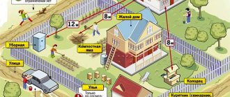
For the safety of residential areas, these objects must be separated from residential buildings by sanitary protection zones.
Owners of industrial and economic facilities must take care of their improvement and comply with sanitary and environmental standards. This work is carried out at their expense. Territorial zoning of each settlement is carried out taking into account not only urban planning, but also land legislation.
This is a complex and responsible process that allows for planned, rational use and development of every meter of the settlement’s territory. Zoning is carried out on the basis of regulatory documents adopted by local authorities.