Home / Real estate / Land / Land survey / Cadastral passport
Back
Published: 03/05/2017
Reading time: 8 min
0
939
If you have purchased, inherited, or received a plot of land from the state, it is advisable to immediately obtain all the necessary documents for it to prove ownership.
This will help to avoid problems with neighbors when determining the boundaries of the site, as well as during its further sale, donation or inheritance.
- What is called a cadastral passport for land?
- Who makes cadastral passports?
- Where do they order and issue a cadastral passport for land?
- Who can use the service of ordering a cadastral passport?
What is it for?
KP is an extract from the real estate register. It includes information about the owner and the site. It should be obtained if basic information has changed or you have purchased a new plot. The passport must be kept with other property documents. Without it, it is impossible to make legal transactions with land or independently calculate the correctness of the accrued tax.
The following information is entered into the State Land Cadastre:
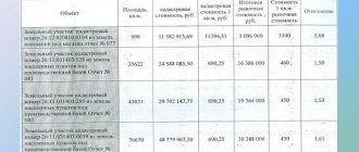
| Basic information about the object | Its purpose, location and size of the territory |
| Schematic illustration | It is available if a preliminary land surveying procedure has been completed |
| Information about restrictions on rights | They may appear if you used the land as collateral or bought it with bank funds. |
A passport is needed to make almost any transaction with the site. It must be provided in the following situations:
- when selling land;
- upon receipt of a building permit on your own site;
- when using property as a mortgage or for inheritance;
- during legal proceedings with neighbors regarding the determination of territory boundaries;
- when renting land;
- when using the site as the authorized capital of the resulting legal entity.
Not all owners understand why a control panel is needed. It contains information about the price, features and size of the territory. It includes information about the owner. If you are planning to sell land, the first thing a potential buyer will ask for is documents. Therefore, they must not only be available, but also in order.
Comparative analysis of market and cadastral prices of land plots
The cadastral and market value of a land plot are different. Usually the cadastral price is slightly lower. It should not significantly exceed the market value, since it is from this that the tax is calculated. If there is a discrepancy, you must resort to expert assessment. Otherwise, you will have to pay high taxes.
Without this document, it is difficult to prove your rights to dispose of property. It will be required in case of any legal disputes. With the help of CP, it is possible to accurately identify land not only in the real estate register, but also in the tax service database.
If legal proceedings arise, your passport will confirm that you are right. It contains information about the owner and the characteristics of the territory belonging to him. It can be used to determine the boundaries of the territory.
The sample document creates the correct idea of what data the finished passport should include. Without this information, it is impossible to officially donate or sell the land. In addition, information about the cadastral value is needed for the correct calculation of tax at the tax office.
How to read it?
Not everyone is able to understand all the information contained in the passport. To do this, you need to carefully read the document and its main sections.
The document must contain the following information:
| Items | Characteristic |
| Cadastral value | It is used to calculate land tax. To determine it, averaged parameters are taken into account. If it is significantly higher than the market value, you have the right to conduct an independent examination and appeal to the district court. |
| Location | The full address is indicated here. If it is impossible to indicate it in full, guidelines are included in the document. In some cases, employees of the Cadastral Organization draw up a detailed description of the route to the site. |
| Owner information | They must exactly match the passport data from your civil passport. There should be no errors in them. |
| Description of boundaries | It is carried out in accordance with the boundary plan. If land surveying has not been carried out, boundaries will not be established. To obtain this document, you will have to call a cadastral engineer who will take the appropriate measurements. |
| Cadastral number | It allows you to identify the area. If the CP is lost, it can be easily restored using this number. |
From January 2021, changes to the Federal Law “On the State Real Estate Cadastre” regarding mandatory land surveying will come into force. Now any owner is obliged to carry out land surveying. If you do not do this, you cannot donate the land, sell it, or prove your case regarding the boundaries of your own territory in court.
Study all sections of the document. There should be no errors in your passport data and information about the site. If they are found, you need to submit a request to Rosreestr to make corrections. If there is disagreement with the amount of tax, the cadastral value of the land plot is assessed. Its results allow you to make corrections to the information.
Who can order and on what basis?
According to clause 5 of Article 7 of the Federal Law of the Russian Federation “On State Registration of Real Estate”, the information contained in the Unified State Register of Real Estate database is publicly available. This means that any individual or legal entity, including citizens of the Russian Federation and representatives of other states, can obtain a cadastral extract for a land plot.
You should be aware that certain types of statements have limited access. This includes a certificate from the Unified State Register of Real Estate on the contents of title documents, on all rights registered to a specific person, etc.
Such information is confidential and can only be obtained by the owner, his representative and other categories of persons listed in clause 13 of Art. 62 Federal Law of the Russian Federation “On State Registration of Real Estate”.
As a rule, the need to obtain a cadastral extract for a land plot arises when it is planned to carry out any legally significant actions in relation to it.
Thus, the basis for requesting such information may be:
- the desire of the future buyer (tenant) to independently verify that the seller (lessor) is the owner of the alienated land plot;
- obtaining information about the presence/absence of encumbrances registered on specific land (for example, in the event of its sale);
- the need to provide such an extract to one or another authority (for example, to a judicial authority);
- other situations.
Its validity period and replacement
In accordance with Art. 4 Federal Law No. 221 KP has no limitation on the period of validity. It is only an extract from the database, which contains the most complete data about the site. The extract will be current until the owner or status of the site changes. In case of changes, you must write a statement to make corrections.
Changes to the CP are made in the following cases:
- when the owner changes;
- when the status of the land changes;
- when land becomes the property of the state;
- when the cadastral price changes;
- in case of elimination of errors;
- when dividing the territory into several separate sections;
- when combining several sections into one.
Sample CP
When dividing the territory into several sections, it is necessary to carry out land surveying. To do this, you should call a cadastral engineer who will take measurements. It is important to use the services of qualified specialists, a list of which can be found on the Rosreestr website.
Based on the results of your work, you will be able to draw up documents for each formed area. As a result, they are recognized as independent, and the owner has the opportunity to dispose of them at his own discretion.
Land surveying
If no changes occur, the document will be relevant for many years. But at the moment there is an obligation to conduct an inventory of sites at least once every 5 years. This is important to identify possible changes. In this case, you need to get a new document. If nothing has changed, it is not necessary to change your passport.
Step-by-step replacement instructions
Any significant changes in information require obtaining a new passport sample. For example:
- When reorganizing an allotment by merging several plots into one, or dividing one plot into two or more.
- When renaming a settlement, street or house numbering.
- In case of detection of overlapping boundaries and when adjusting their location by land surveying. For example, when reducing the area or increasing it due to cuttings.
- In other cases, changes in the coordinates of boundary boundaries or turning points.
- When changing the category of land or the intended purpose of the land plot.
- After an audit of the land mass, if the cadastral value of the land plot has been revalued.
- If the cadastral value has changed as a result of a court decision.
The algorithm for replacing a passport depends on the purpose of the procedure . The main basic steps are as follows:
- Contact your local cadastre and cartography office or MFC with an application.
You need to contact the registrar using the electronic queue number received at the institution’s terminal. Application for amendments to the cadastral passport of the land plot. - In the application, indicate information that is no longer relevant and formulate a request to replace it, indicating current information.
- If the site is not registered in the cadastral register, first contact a geodetic company and carry out land surveying.
- Pay a state fee of 200 rubles and attach a receipt to the application.
- Attach documentation to the application confirming the need to change the information. This could be a certificate with an independent expert’s opinion, a court decision, an administrative act to change the street name (house number) or other documentation.
- If the information has changed after the land audit, indicate this fact and, if necessary, confirm it with a cadastral extract.
- When registering for cadastral registration, indicate the fact of land surveying. The same applies to establishing boundaries with neighbors.
- After submitting the application and package of documents, expect the issuance of a new cadastral passport within 5 working days.
- When ready, receive the document for signature.
Only the owner of the plot can receive a cadastral passport in person, or a representative of his interests, acting on the basis of a notarized power of attorney.
When the owner of the storage unit changes
Since the personal data of the copyright holder is not indicated in the passport, changes are not required when changing the owner’s surname or after a property transaction . All entered information remains relevant until the specified land parameters change.
Recovery procedure
If you lose your passport, you need to restore it. The owner must perform the following sequence of actions:
| Stages | Description |
| Contacting the MFC or the Cadastral Chamber | Fill out the application and provide the documents you have for the site |
| Payment of state duty | Its size is 200 rubles |
| Receiving a receipt | An employee of the MFC or Cadastral Organization will issue a receipt for receipt of documents |
| Documents receiving | After 10-14 days you will be given a new CP and the provided documents will be returned. |
This procedure is not difficult to complete. But it is better to do this in advance, since if necessary, you will not be able to quickly obtain the necessary documents.
How to find out if it is in stock
Many owners don't know if they have a CP. If it is not available, you can make a request at the Cadastral Office. In the application for this, the exact address is indicated in order to identify the location. If it is not there, indicate the approximate location and parameters of the site. You can also find it using the owner’s passport details.
A passport will be provided if the relevant data is in the database. In this case, a unique number is indicated in the register. The owner of the participant will only have to request a copy of the CP. To do this, you need to submit a package of documents with the appropriate request.
The CP is the most important document that must be protected. If you cannot find it in your documents, contact the appropriate authority.
What data is displayed in the cadastral passport
The cadastral passport for a country house, land contains several sections, which display:
- Common data . Legal address, area, territory boundaries, number, cost, etc.
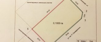
- Measurement plan/schematic representation of the site . The drawing is published with the scaling specified in the legend.
- Presence of encumbrances . If there are restrictions on a land/dacha plot, it cannot be alienated (to protect property rights). Such information must be displayed in the table.
- Clear description of boundaries . Not only the size, but also the shape of the land plot, as well as its corners and turning points are indicated.
The cadastral passport specifies not only the type of land, but also the purpose of its operation.
How to check online: instructions in screenshots
Before contacting Rosreestr or MFC, you can check the availability of information about your site online. To do this you need to follow the link.
Window of reference information on real estate objects on the Rosreestr website
By filling out the form, you will find information about your site available in the database. The easiest way to find a plot is if you know the cadastral number. But if you do not have this information, enter the most detailed address of your site.
Searching for data by memory address
After that, click on the “Generate request” button. If you provide exact information down to the house number, you will see your site. But if you don’t remember the exact address, you can indicate the subject and locality. As a result, you will see a list of plots located in the selected locality.
List of sites in a given locality
Select the area you need from them.
Complete information on the selected memory
The information available in the database will appear in front of you. It includes the following information:
- cadastral number;
- object status;
- date of registration;
- land area;
- type of permitted use and category of land;
- location address;
- information about cadastral value.
If the register contains data about your plot, you can go to the Cadastral Office to obtain a passport.
Where can I get a cadastral number for a land plot?
The plot receives this number when it is registered in the cadastral register. In the future, it does not change, even if the land changes ownership. Some changes can only happen by dividing or combining with others. But in fact, in this case, the previous site ceases to exist.
Rules for assigning a cadastral number
There are certain rules. The number consists of a set of numbers. They are divided into 4 groups, which are separated by colons. These groups are (in order):
- district;
- area;
- quarter;
- the site itself.
Conventionally, the number can be represented as aa:bb:ccccccc:ddd. In one district, all precincts have similar numbers in the first group, in one district - in the first and second, etc. And only the last numbers are not repeated.
The sale of a share of a land plot can only be carried out with the consent of the owners of the remaining shares. What is land demarcation and how is it carried out? All information on this issue is in our article. What steps need to be taken and what needs to be taken into account in order to carry out land privatization correctly? Find out about it here.
Methods of obtaining
How you choose to submit your request is a personal choice. The application can be submitted as follows:
- through the Rosreestr website;
- through the government services portal;
- via postal mail;
- by personal contact to the Cadastral Chamber or MFC.
One of the most reliable ways is to personally contact the MFC or Cadastral Organization. In this case, you will receive an official document. It will be certified by the official seal and signature of the responsible person. If the conflict is resolved, you will need a paper copy.
Receipt through MFC
Your plot must be in the real estate register. You must know the cadastral number and provide a package of documents. The following documents must be submitted with the application:
- request of the established form;
- boundary plan;
- your civil passport;
- certificate of ownership or extract from the State Property Committee;
- statement about the location of the site in the register;
- act on approval of boundaries;
- receipt of payment of state duty.
The package of documents is handed over to the MFC employee. According to current legislation, the prepared document is provided within 5 days. But in this case, the period is calculated from the date the application is received by the Cadastral Chamber. It will take time for shipping.
Request for provision of CP
In accordance with Appendix 2 of Order of the Ministry of Economic Development No. 343 of July 30, 2010, a citizen pays a fee of 200 rubles. For legal entities the fee is 300 rubles. In the multifunctional center, the fee can be paid through the terminal, so as not to contact the bank separately.
Please ensure that your request is formatted correctly. It must contain the name, passport details and reason for the request. If the data from the request and the registry do not match, the registrar will refuse to accept the documents. Therefore, you should carefully check the data and only then sign the request.
Why do you need to get it?
The need to obtain a cadastral number for a land plot is due to the fact that:
- The presence of such a number with the owner serves as confirmation of the fact that the site is in his ownership . This makes him the full owner of his land and gives him the legal right to dispose of it at his own discretion: a purchase and sale transaction can be made with the plot, gifted to another person or bequeathed to heirs.
- It must be presented to the Federal Tax Service in order for land tax to be calculated correctly .
- The cadastral number is a means of identifying a land plot . Knowing it, an interested citizen will be able to accurately determine its size, boundaries, location, as well as the quality of the lands within the site and their purpose.
It is still possible to try to dispose of a plot that is not registered in the cadastral register, but this is not in the interests of either party to the transaction.
In this case, the potential buyer loses interest in purchasing it, since he cannot receive official confirmation of information regarding the most important characteristics of the site.
Moreover, the absence of a cadastral number may lead to disputes regarding the determination of the owner of land ownership , and municipal authorities in such a situation have the right to raise the question of recognizing it as illegally seized.
In connection with these reasons, the owner of a plot of land who has not yet received a cadastral number for it should be interested in doing this as soon as possible.