Home / Real estate / Land / Land surveying / Land surveying for different types of purposes
Back
Published: 02/26/2017
Reading time: 14 min
0
1870
Land surveying refers to the process of determining the exact boundaries of a land plot and securing such boundaries in the boundary plan of a given plot.
The procedure for marking plots in a garden partnership is carried out according to certain rules by special organizations, and is necessary for legally full use of garden plots.
- The procedure for surveying a garden plot
- Where to begin
- Required documents
- Step-by-step instruction
- SNT territory survey project
- Possible problems during land surveying
The legislative framework
According to paragraph three of Art. 39 of the Federal Law “On Cadastral Activities”, not only tenants and owners of plots, but also those persons who use the land under the right of free or lifetime use can carry out the land surveying procedure within the SNT.
Before carrying out measures to measure boundaries, it is mandatory to notify neighbors along the SNT. This norm is enshrined in paragraph 8 of Art. 39 of Federal Law No. 221 “On Cadastral Activities” dated July 24, 2007.
Why do you need to define boundaries?
There is no need to demarcate the area if you have managed without it before. There need to be compelling reasons to implement boundary-defining activities.
Possible problems
If surveying is not carried out, the following troubles are possible :
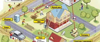
- disputes with neighbors about boundaries;
- it is possible, by court decision, to demolish buildings that stand on a neighboring plot;
- the inability to determine the construction site of any object that must be located at a certain distance from the border;
- inability to sell the plot at a better price;
- the impossibility of combining sections into one or making cuts.
All these problems can be solved by calling a cadastral engineer.
How are disputes resolved?
Disputes with neighbors can be resolved in two ways: peacefully or through the courts .
The second method involves legal fees and costs for a lawyer, but does not guarantee benefits.
Therefore, it is better to agree on boundaries.
This step is registered in an approval act, which is signed by the initiator of the procedure, the owners of neighboring plots and the cadastral engineer.
What is it and why do you need to divide the land?
Let's figure out why you need to do land surveying in gardening? This is because if there is no document confirming ownership rights, then other papers will not help prove your rights.
In addition, one of the main tasks of the process of surveying public land in SNT is to establish precise boundaries on the sides of the site and subsequently receive a document indicating that the land has an owner. Without this procedure, it is impossible to draw up documents for the privatization of the site.
There are cases when the land is owned by the owner without the above procedure. In this case, it turns out that without land surveying, the land cannot be registered as property, that is, from a legal point of view, it was appropriated by squatting, and this is already a violation.
Attention! Another significant advantage of carrying out land surveying in a gardeners’ association is the opportunity to receive up to 10% of excess territory, if any is available for landscaping.
Situations where a dacha plot has not been used for a long time, and then other objects are put in its place or a new owner appears, unfortunately, often occur. Such unpleasant incidents can be avoided only after complete paperwork.
As a rule, ten percent is taken from those plots whose tenants did not take care of timely registration. In favor of land surveying, we can note the fact that people who did not manage to register the land for gardening needs within the deadline set before January 1, 2021, will no longer be able to do this. Lands left without registration will be considered the property of the state.
Land surveying of a garden plot can be carried out by companies licensed to carry out such activities, or by cadastral engineers. If there is no license, this cannot be recognized as a legal distinction.
Features of project preparation and site maps
When carrying out land management work on a territory that will later be divided into several plots, a special document is left - a land surveying project. This also happens when surveying land owned by SNT.
To order boundary work, you first need to obtain permission from local administrative authorities , issued in the form of a resolution on the allocation of territory for the use of a gardening partnership.
Based on this, the organization is obliged to carry out boundary work on the received land, as stated in paragraph 4 of Article 39.10 of the Land Code of the Russian Federation. The plan and map of the plots obtained during the research is the basis for further delimitation of lands by the owners of the plots included in the SNT.
The drafting is carried out in several stages :
- decision-making by administrative authorities on the use of certain lands in the SNT;
- preparation of a land surveying project by an authorized company;
- coordination of the received plan with the local administration;
- if necessary, making corrections to the boundary plan;
- approval of the document by territorial authorities.
Only after drawing up such a project and its approval, a specific plot located on the territory of SNT can be allocated to gardeners, as reported in paragraph 3 of Article 11.3 of the Land Code of the Russian Federation.
The graphic section of the general land boundary plan of SNT consists of :
- public lands highlighted with a red line;
- points indicating the maximum proximity of the site to the boundaries of the PDO;
- boundary lines of areas included in the SNT;
- turning points with the designation of their coordinates;
- designated zones designating roads, driveways and other objects of the category of public easements.
Is this procedure mandatory in gardening?
Carrying out land surveying is not a mandatory procedure in all cases , and many gardeners are thinking about implementing it or abandoning it. This is due, first of all, to the high cost of carrying out the work and ordering the services of a special company with geodetic equipment.
The fact is that relaxations for this kind of areas are regulated by rules that are in force until January 2021. This can be read in Federal Law No. 447-FZ.
After January, any actions related to legal transactions or other procedures should be carried out only with documents on the land survey. The following facts speak in favor of this procedure:
- If we are talking about the sale of the SNT plot, it is unlikely that there will be anyone who will want to purchase the plot without a boundary plan.
- In a dispute with neighbors, you cannot do without a plan. He will help defend his rights to the land.
- If a house is planned to be built on the site, then a boundary plan is indispensable.
- After 2021, no transactions with the site will be possible without land surveying.
There is no garden plot, but there is a country house? The question is: is it necessary to survey such land?
All the answers and descriptions of the nuances of the procedure are in this article!
How are powers transferred to the head of SNT?
The legislation allows for collective organization of the process. A trusted person can easily handle the matter. People who have received a power of attorney from the owners will deal with cadastral specialists and government officials.
To transfer rights to one person, SNT members write a power of attorney to the head of the SNT. The power of attorney must be from each member of the company. The representative will express the interests of each and every person; in this case, he will face a number of problems:
- Caring is unpleasant, it will require a lot of time;
- If land surveying is not covered by the amnesty for summer residents, then you need to pay a certain amount. The monetary investment will be based on the region of the Russian Federation, location and commercial value of the land. In this case, it is difficult to achieve collective unanimity among gardeners: for many it will be an unaffordable amount. You can calculate the average cost of land surveying here.
But collective land surveying also has its advantages. The trusted person will free up the time of the other comrades; this approach rarely causes disputes between neighbors on the issue of plot boundaries.
When is it not required?
There are some exceptions when there is no need to carry out measuring work at the SNT site. This exception recognizes the registration of land on the basis of the law on dacha amnesty .
This applies to the registration of SNT land plots, as well as individual construction. In order to become the full owner of land property, a measurement procedure is not required.
For such objects it is not necessary to carry out a land surveying procedure, but in order to avoid further disputes with neighbors, it is recommended to take measurements and draw up a new site plan.
Survey results
Upon completion of the work, the engineer prepares a plan and submits it to the owner. To register a document, you should contact the Rosreestr office. You can submit an application in the following ways:
- in person at the Unified State Register of Real Estate;
- through the MFC;
- by mail;
- submit an online form on the organization’s official Internet resource.
The period for consideration of an application for plan registration is 14 working days. At the end of this period, the citizen is notified of the results in the manner specified in the application.
If you have a gardening book
So, let’s figure out whether it is necessary to survey a land plot in SNT if such a condition exists? By law, it is not necessary to carry out the procedure if you already have a gardening book.
A person must decide this issue himself, guided by the goals and needs that are intended to be carried out in relation to the site of the garden association.
If the plot is planned to be sold or separated from public use, then experts recommend carrying out land surveying work.
Who should carry out the procedure?
The Gardeners' Association is not obliged to take any measures to prepare documents. The responsibility for calling specialists in the field of land surveying falls on the shoulders of the owner , that is, the one who uses the SNT land plot.
If novice gardeners want to purchase a plot of land for flower beds and planting fruit and vegetable crops, experts do not recommend purchasing those plots that have not had a land surveying procedure.
This is explained by the fact that if the responsibility for the process is assigned to the new owner, he will invest significant sums, which will not please a thrifty person.
What types of boundary plans are there?
Land survey plan
There are several types of boundary plans. There are three main subgroups of boundary plans:
- To form a plot of land. This is both a combination and division of land plots. You can combine two or more areas that have an adjacent border, but are divided into two or more parts. Also, such documents will be needed when allocating land plots, when distributing plots, as well as when forming a plot from different lands.
- A boundary plan can be created in order to clarify the boundaries of a land plot.
- To correct cadastral errors.
When forming all these plans, there are many nuances that can only be entrusted to professionals.
Do neighbors need signatures?
Even if the owner of the plot has never seen the owners of other plots and does not know whose land is located in the adjacent territory, they need to be found, because It is required to collect signatures from neighbors . If contact between the landowners of the garden association never took place, you need to send a letter via postal service.
That is, to the question of whether this is necessary and whether it is necessary to collect signatures from neighbors in the dacha area, one can give an unequivocal answer - yes.
If there is no response to the letters, you can publish the appeal in the local newspaper. You need to wait for a response within a month, if no negative or positive response was received from the persons to whom the letter was sent, then after a month the procedure for surveying the SNT site is considered agreed upon and you can use the services of surveyors.
However, if a neighbor disagrees with the procedure, then the dispute can only be resolved in court.
If the site has no neighbors, then you can carry out the land surveying procedure according to a simplified scheme , referring to Federal Law No. 93-FZ, ed. 2021 “On the dacha amnesty.”
Of course, you can’t know everything for sure, but this option with a simplified system is only applicable if you are one hundred percent sure. If the neighbors do appear, they will begin to make claims and also accuse them of seizing their share of the plot.
Important! Experienced legal experts advise sending not one, but two or more letters in order to obtain a response.
From all of the above, we can conclude that the neighbor’s signature matters if he really exists . If the owner of the plot is sure that he is surrounded by ownerless land, then he can call surveyors, but if this turns out not to be the case, the neighbor has the right to sue the invader of his territory.
The procedure for preparing a boundary plan for a land plot
We will walk you through the standard plan preparation process.
- First comes the preparatory stage. You need to find out the purpose for which this work is being carried out, an agreement is formed with the customer, and all documents are studied. This is a very important stage. Thanks to it, you can immediately find all the errors that may be in the documents, correct them, and discuss all the nuances. If errors are not found at this stage, then later they can greatly interfere with the preparation of the plan and slow down all the work. It is at this stage that documents are prepared that are not enough to prepare a boundary plan.
- Then field work takes place. Sometimes this is not necessary. But if there is no data about the site in the register, then it will be necessary to take measurements. They need to be carried out as accurately as possible so that later the register contains absolutely accurate dimensions of the site. If you take incorrect measurements, this can greatly hinder you in the future. Not only the boundaries of fences are measured, but also the boundaries of natural objects, for example, rivers or forests.
- Then all the information is processed, the final plan is prepared, which is later transferred to the registry along with the accompanying documents about the site. This can be done by both the customer and his authorized person.
After successfully completing all stages, you will be issued a cadastral passport.
detailed instructions
So, in order to carry out the surveying procedure, you need to go through the following stages when contacting a company that provides geodesy services. The financial cost of the work will depend on the company’s prices, but usually the price is set on an individual basis.
After contacting the company’s employees, they will offer to conclude an agreement with them, for which the following documents will be needed:
- If another person is involved in the registration procedure, he needs to have a pre-certified power of attorney and a passport.
- A document indicating receipt of ownership rights to a specific plot of land within the SNT. Such documents may include a certificate of ownership or a contract for a purchase and sale transaction, etc.
- Some companies may ask for a foundation agreement.
- Identification document of the applying owner.
Sometimes the owner of the site provides the company with:
- A certificate confirming the absence of communications belonging to the public.
Such a document can be obtained by contacting the administration of the district where the dacha plot is located. A special technician will check the plot and draw his conclusions, refuting or confirming the presence of equipment. - Certificate from the mountains. light, where it is stated that no electrical cables are laid on the territory of the land plot.
The second stage of work consists of notifying neighbors in the gardening community about the upcoming land survey. This must be done no later than a week before the proposed work. They must personally be at the survey site and monitor the progress of work.
In self-notification you must adhere to the following scheme:
- Write the text by hand and send it to each of your neighbors by mail.
- Go around the neighboring gardening plots and tell them about the upcoming event, while handing them a notification to sign.
- The engineer receives notices from the owner of the site with the signatures of the neighbors.
Form of notification of the land surveying procedure.
Notification work can be ordered from a company; the approximate cost of notifying one person will be 250 rubles. Those who have free time can do their own search for the owners of a plot in the neighborhood.
It is important to note that neighbors must be warned about upcoming work , but if for some reason they do not show up for land surveying, surveyors will begin work without them.
This is not considered a fundamental factor for refusing land surveying. The next stage will consist of measuring the boundaries of the entire garden plot and recording the results in a special land surveying act.
With each marking, neighbors will be asked whether they agree with the measurements taken or not. After the land surveying process, the act is signed by the following persons:
- the owner of the measured plot or his chosen representative;
- neighbors from adjacent SNT lands, if they participated in the measurements;
- the engineer who carried out the measuring work;
- a representative from the administration, upon notification of the company.
The last step is to visit the company on the day that will be appointed. The owner will be given a land surveying certificate after the surveying company has carried out the work.
In the event that the boundaries of the measured area have changed after measurements, you need to proceed as follows :
- The owner needs to take the act to the District Committee responsible for land resources. There it must be signed and on the day that is chosen, it can be picked up.
- After this, you need to take care of including the site in Rosreestr, and to do this you need to go to the MFC or a branch of Rosreestr.
- Pay the state fee of 1000 rubles.
- Sign the application filled out by the registrar.
- After this, the registrar will take all the documents except the identity card and issue a special certificate confirming their acceptance. On the day written in the certificate, you will need to appear to receive documents.
Requirements for the boundary plan
The requirement for how a boundary plan should be drawn up and how it should be executed is contained in several federal laws. In order to know exactly how to draw up a land plot plan, you need to study the following documents:
- No. 136-FZ “Land Code of the Russian Federation”. This is the main document. Here you can find absolutely all the information about how land relations work and what they consist of.
- No. 221-FZ “On the State Real Estate Cadastre”. It tells about the cadastre, what it consists of and how to maintain a land cadastre.
- No. 412 “On approval of the form of the boundary plan and requirements for its preparation, an approximate form of notice of a meeting to agree on the location of the boundaries of land plots.” This document will tell you how to properly prepare an interplane, what the requirements will be for it, and what you will need for this. If you are planning to prepare such a plan, then you need this document.