Land surveying is a process that involves clarifying and determining the boundaries of lands, their locations and areas. Without going through the land surveying procedure and without having an up-to-date land survey plan on paper and electronic media, it will be impossible to make any disposal of the property - sale, rental and even inheritance.
What to do after the site surveying procedure and how to use the survey plan will be discussed in this material.
Federal Law on Land Surveying, Dacha and Garden Plots: Basic Definitions
There is no separate regulatory legal act regulating exclusively the provisions on land surveying in the Russian Federation.
The law on land surveying in the Russian Federation can be called the Land Code; it was adopted in January 2001. The Code consists of chapters and articles. It reflects the main provisions regarding the delimitation process, the state cadastre, the rights and obligations of a separate group of persons.
Legislation on land surveying activities also includes the basic concepts that must be used in this process:
- Land surveying is the establishment and registration of boundaries on a piece of your land.
- Boundary – the boundary of land holdings.
- Ownership of land is the ability to own, use and dispose of it.
- Horticultural lands are lands not intended for individual housing construction, but adapted for growing fruit and vegetable crops.
- Interleaving is repeated surveying, which is carried out by a specially authorized person already in the demarcated area in order to clarify certain information.
- PDO – public lands.
This is not the entire list of concepts used in this procedure, but they are the main ones and are most often used.
What is land surveying under the new law?
The new federal legislation of 2021 (Federal Law 477) established that citizens have the opportunity to carry out the land surveying procedure free of charge. This applies to persons who live in certain regions. This Federal Law came into force on December 29, 2014.
The program list includes the following regions:
- Stavropol.
- Sevastopol.
- Perm region.
- Kamchatka Krai.
- Amur region, etc.
Land surveying occurs in five stages, each of which has its own distinctive features, which will be discussed later.
Cadastral number
A cadastral number is a unique numeric value that allows each individual plot of land to be identified on a public cadastral map.
In order to determine the cadastral number, you can refer to the following sources: purchase and sale agreement; land title document; cadastral passport. To determine the cadastral number, you can also refer to the data contained in the regional Rosreestr. Since today all databases are united, you can obtain information about land located in any region of the Russian Federation.
What the law says
In cases where land surveying is required, the procedure for its registration is prescribed in the following regulations:
- Federal Law No. 218 on registration of rights to real estate and transactions with it;
- Land Code of the Russian Federation;
- Law on the State Real Estate Cadastre;
- Law on Land Management, etc.
The presence of a survey act when conducting transactions or registering legal procedures with land is a guarantee of the legitimate status of the site. It is almost impossible to challenge the contract due to the lack of clear boundaries of the plot or the emergence of a dispute between the owners of neighboring plots.
This is due to the fact that in the course of conducting land surveying, an act of determining the boundaries of the land is drawn up, which is signed by the neighbors or established legally through the court.
An important condition for conducting land surveying is that the procedure be carried out by accredited legal entities that have SRO approval to carry out this type of work. Citizens or other organizations do not have the right to conduct such events.
According to the law, it is possible to register a plot when the procedure is carried out without land surveying. The list of mandatory documents in accordance with Federal Law No. 218 includes a cadastral passport or an extract from the Unified State Register of Real Estate (an innovation since January 2017), on the basis of which the location of the land and its area are determined.
Land surveying procedure
The land surveying procedure essentially consists of several stages.
By virtue of the law, the owner must enter into an agreement with a company licensed to perform the procedure . The contract also determines the cost of the work. It is necessary to demarcate the site according to the rules provided for by Russian legislation.
This was the first stage of the procedure.
As for the second stage , here you need to collect the necessary documents. Their list includes the following acts:
- owner's passport;
- certificate of ownership;
- consent of neighbors if the site is located at the intersection with another;
- acts on the absence or presence of communications on the site.
The geodetic service has no right to require any other documents.
The third step is to notify neighbors in the area about the relevant work. Such notification must occur within a period not exceeding seven days, otherwise, neighbors have the right to demand the cessation of this type of work.
For a separate price, a surveying company can also take care of the notification issue. The concept and definition of the notification procedure in this case must be spelled out in the contract itself.
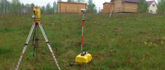
The fourth step is the arrival of employees of a geodetic company to the site to carry out the necessary measurements, determine the boundaries of land plots and sign control acts. At this moment, the price under the contract, as provided initially, cannot be increased.
It is necessary to carefully read the text of the drafted act, since it is on this basis that the boundary plan will be prepared. This applies to garden plots in SNT, and for summer cottages. The terms for land surveying established in the contract must also not be violated.
The end of this procedure is the fifth stage. After the last necessary actions have been carried out, the execution of the contract is marked by the publication of a special act - a boundary plan. It is necessary when registering land ownership and carrying out other legally significant actions with the land.
Who needs to do land surveying according to the new law
The new law obliges all those persons who occupy land plots for the corresponding purpose to carry out the land surveying procedure.
As a rule, land must be demarcated when it is subject to subsequent sale. In the absence of land surveying, many legally significant actions with the land will not be possible. Of course, if the land has already been demarcated, then there is no need to repeat this procedure. We are talking only about those areas for which there is no data in the public cadastral map. In some regions of the Russian Federation, this procedure is free, as mentioned above.
When is it required?
When carrying out a transaction for the purchase and sale of a plot, land surveying documents will be of primary interest to the buyer. After all, they will protect him from many unpleasant situations in the future.
According to Federal Law No. 221 of 2007, mandatory land surveying has been abolished, but in order to actually carry out the bulk of transactions with land and any civil legal actions with it, accurate information about the boundaries of the plot is necessary.
Surveying may be necessary in the following cases:
- Before the sale, lease, exchange, donation and other actions in which the owner of the land changes. If the cadastral registration passport during the re-registration of the territory indicates its approximate area, then subsequently the new owner will face many troubles.
When registering the property as a property. The cadastral plan is included in the list of necessary documents for this operation, and it can only be obtained after carrying out land surveying work.- If you intend to combine plots or, on the contrary, divide one into several.
- When changing the boundaries of the site and their legal registration.
- To resolve disputes with the owners of adjacent plots in court. In this case, the law sides with those who carried out land surveying earlier.
- When cutting off vacant land (up to 6 acres or up to 10% of the total area of the existing plot). This is a legal way to increase the area of your own plot.
- When heirs allocate their shares of the inherited plot for the purpose of their further sale or donation.
- To protect the boundaries of your site from unscrupulous city planners planning general development.
- If you intend to erect a large building on the site. Without a clear definition of the boundaries of the land, approval and subsequent registration of the structure is impossible.
- If the boundaries of the land have a complex configuration. This will protect him from claims from third parties.
If the site is located in a gardening partnership, then existing undeveloped territories may find an owner when land surveying activities are carried out on them.
Who does land surveying for free: new law
You can count on free surveying by contacting state geodetic companies.
Among other things, in each region a list of private firms is formed that operate on the basis of a state or municipal contract. In such organizations it is also possible to demarcate land for free.
How to order land surveying for free
In order to place an order, you must contact the state surveying company or the city administration in order to indicate your right to carry out the survey procedure free of charge.
Deadlines for land surveying according to law
As a rule, the terms of surveying procedures are prescribed in the contract with the geodetic company, however, at the legislative level there are time limits.
Thus, land surveying work must be completed within a period not exceeding five days, and completed documents must be issued within a period not exceeding two weeks. Another thing is with land registration. Here the procedure may take a month.
How to arrange land surveying
Land surveying is formalized by issuing a special act called a land survey plan. It is in it that the boundaries of the land plot, its location on the public geodetic map and other essential information are clearly stated.
What to do after land surveying
It all depends on whether the right to your land plot is registered or not. In the event that registration has not taken place, then the boundary plan will serve as the basis for registration.
Also, without a boundary plan, it is impossible to carry out the purchase and sale of land.
Is it possible to carry out land surveying without documents?
If there are no permits for the land plot (they were not issued or were lost), then get ready for a long and financially expensive process to restore them.
For this purpose, apply for the issuance of a description of the land plot to the territorial department of the BTI. Order cadastral work from a company that provides the relevant services.
Before carrying out land surveying, issue a cadastral passport and resolve all disagreements with neighbors.
Prepare for the fact that the process of establishing the boundaries of the land plot, taking into account the restoration of documentation, will take at least 3-4 months. Then send the title documents and the plan obtained as a result of the land survey for registration to the Rosreestr service. As a result of the efforts expended, you will be the rightful owner of the land plot.
Was the Recording helpful? No 41 out of 50 readers found the post useful.
Sale of land without land surveying
There were rumors in the legal community that if the land plot is not demarcated, then it is impossible to sell it.
Indeed, few buyers will agree to purchase such a plot on the condition that he will have to carry out all the legal procedures himself. However, there is no direct legal prohibition on this. It is impossible to invalidate a contract on the grounds of lack of land surveying.
But it must be borne in mind that legislators have long wanted to limit the actions of citizens in the purchase and sale of undemarcated land. Changes to legislation may come into force at any time.
Preparation
The primary task of the land owner is to choose a specialist. It is necessary to pay special attention to his qualifications and competence in the matter of drawing up a boundary plan. The list of accredited organizations providing arpantage services is constantly updated by Rosreestr and posted on its official website, as well as on the information stand in its branch.
All of these specialized organizations have their own advantages, disadvantages and prices. Their choice depends on the individual wishes of the customer.
Stages of memory formation
The cost of services provided may vary depending on the characteristics of the site; therefore, in order to avoid unplanned expenses, the customer, when concluding a contract, has the right to require an estimate of the planned work.
To draw up an agreement and carry out land surveying activities, the cadastral engineer will need documentation of the superimposed boundaries of the site. It must be collected in advance. Before starting work, the engineer must obtain and study all information about the land available in the cadastral registration and cartography department.
Download the federal law on land surveying, summer cottages and garden plots
You can download the latest version of the law with amendments and additions right here. ⇐
So, to summarize: actions with land are legal only after the land surveying procedure. You can order a boundary plan in accordance with Federal Law No. 221 from authorized companies.
Only accredited companies or government entities can carry out the procedure for delimiting your site and make its plan. Information about whether land surveying was carried out and what cadastral number of the land is available on the Rosreestr website. The obligation to carry out this procedure is not established by law.
Implementation rules
The purpose of the survey is set by the customer depending on his specific needs:
- clarify the boundaries of the land;
- install signs fixing boundaries;
- conduct an examination for proceedings in court.
Since land surveying is a mandatory part of most allotment transactions, the procedure should only be trusted to accredited private or public organizations.
Carrying out the land surveying procedure
Only licensed specialists have a sufficient level of knowledge of the Land Code of the Russian Federation, experience in the field of geodesy and cartography and are able to take into account all the features of each specific case. Despite the fact that the procedure follows the approved procedure, it is important to take into account and understand all the circumstances of its implementation.
Upon completion of the survey, the customer receives two copies of the survey plan. One of them is kept by the owner of the plot, the second is sent to the cadastral register and cartography department of the municipal administration.
What does the act of land surveying look like?
A correctly completed document must contain the following information:
- Last names with initials of all persons interested in this issue.
- Details of passports or other identification documents.
- Results of coordination (joint or individual).
- The final diagram of the boundaries of the site indicating the coordinates.
- Objections from interested parties (if any).
- Seal and signature of the engineer who carried out the survey.
- Signatures of neighbors who expressed consent.
Thus, the land surveying procedure can be a long and labor-intensive process. But you can’t do without it if you want to legally formalize your plot and register it. Remember that you cannot make any changes to the land without surveying, otherwise various problems may arise, including lengthy legal proceedings.
- Author: Anastasia
Rate this article:
- 5
- 4
- 3
- 2
- 1
(8 votes, average: 5 out of 5)
Share with your friends!
How to sell an undemarcated plot?
In practice, there are often cases when the owner sells a plot that is not registered in the cadastral register. Before putting such land up for sale, you need to register ownership of it.
An extract from Rosreestr will allow the parties to determine all the parameters and legality of the transaction. It also contains important information about the presence or absence of encumbrances, which can certainly influence the decision on the transaction.
The procedure for the parties is as follows:
- Visit the Cadastral Chamber and request an extract from the local administration that provided the land;
- Conclude an agreement with a cadastral engineer who will issue an act establishing the boundaries of the site;
- Submit an application to Rosreestr for the issuance of a cadastral passport;
- Conclude a preliminary agreement on advance payment (deposit);
- Prepare all documentation and conclude a basic agreement;
- Make payments using a safe deposit box;
- Register the agreement by providing all required documents, including an extract from the cadastre.
Don't forget about your neighbors
Before the cadastral engineers arrive, you need to warn your neighbors that boundaries will be established. Neighbors must confirm that they agree with the boundaries of your property. The engineer will draw up a land survey approval document, and neighbors’ passports will be required here. And if the allotment belongs to a dacha or garden partnership, then the consent of the chairman of the board will also be required.
If we do everything together, there will be no disputes. If neighbors refuse, then all refusals must be documented. But it is always cheaper to compromise, since litigation is long and expensive.
New rules for drawing out site boundaries in real life
The construction of a residential building is permitted only on lands classified as “land of settlements”, as well as on agricultural lands allocated for the construction of summer cottages. On ONT lands, that is, in vegetable gardens, the construction of buildings for economic purposes is permitted.
According to the new law, it is still allowed to build a house on a garden plot for seasonal use. However, according to paragraph 2 of Art. 23, in order to build such a house, not only compliance with the category of land is required, but also coordination with the general plan of the municipality.
What changes have come into force in 2021?
The main provisions of the new federal laws will come into force from the beginning of 2021. Although, in essence, apart from the mandatory land surveying, the legislative framework on land has not undergone any significant changes. Only the procedure for joining and participating in dacha and garden partnerships has changed.
Registration, as before, is possible on plots belonging to a certain category of land (with the purpose of individual housing construction or private household plots). However, before this, it is necessary to register the building, observing all the rules. Experts believe that the settlement of this issue will be contained in additional acts.
Documentation
After completing the survey, you need to document its results: in addition to the survey act, a survey plan is also drawn up. This is the most difficult part of the work, but they are completely taken care of by the contractor, which means that the owner of the site does not have to worry about documentation - after a certain time he will receive a ready-made boundary plan, with which he will complete the registration by contacting the Cadastral Chamber.
Land survey plan
It consists of several dozen pages and contains comprehensive information about the site, and not just the plan itself. Due to the fact that the document is very voluminous, we will note only the most important points:
- basic data about the site;
- information about what measurements were taken during surveying;
- geodetic diagram;
- layout diagram;
- blueprints;
- applications.
Registration requirements
As a rule, survey companies provide the plan electronically, although it can be printed if necessary. Usually, an electronic version is needed for further processing. The requirements for document execution are contained in Order of the Ministry of Economic Development No. 921.
After completion of the preparation and verification, the plan is signed by the parties and a certificate of completion of work is drawn up in two copies for each of the parties. After this, the survey company’s participation in the case ends, unless government agencies have any complaints about its work and nothing has to be redone.
Is it possible to speed up the surveying time?
Land surveying and preparation of the plan will take approximately two weeks. It is quite possible to agree with the contractor on an expedited procedure. It is possible to do everything quickly if you immediately involve an expanded work team.
The cost of surveying is also determined on an individual basis. In particular, the influence is exerted by the area, shape of the site, features of the object, urgency of the order, address of the land plot, and the like.
All these points will be spelled out in the technical specifications. You can contact specialists and discuss the terms of cooperation by calling the numbers listed on the website.
Advantages of collective surveying
Within the boundaries of gardening partnerships, “sharing” surveying turns out to be a more profitable solution than ordering.
Main advantages:
- absence of disagreements in the process of coordinated collective action;
- There are several objects, the cadastral engineer can provide a discount on the price of services.
- This solution is ideal for cases of shared use of plots within the boundaries of SNT.
How long does the boundary plan last?
It is important to note that not a single legislative act today contains information about limiting the validity period of the boundary plan.
However, it should be understood that the cadastral registration procedure is carried out on the basis of a boundary plan, which must comply with the requirements of legislative acts, changes to which are made quite often.
What affects operating time
So, let's consider in detail the factors influencing the time of establishing the boundary on the site. These include:
- Open access to the site (if access to the land is limited, the process may take a long time).
- Availability of the necessary information (cadastral data about the object in the USRN authorities).
- Opinion of the owner of adjacent plots (presence of controversial issues).
- Involvement of special equipment to perform the work (it is necessary to find out whether special technical means are required in order to allocate an area).
How much time do you need to notify neighbors?
It is necessary to agree on carrying out land surveying with interested parties (neighbors) within the prescribed period, in accordance with Article 39 of Federal Law No. 221, as well as the Methodological recommendations of Roszemkadastr.
All owners of land plots bordering the land surveying site must be informed at least 15 days before the work is carried out.
If it is not possible to personally deliver the notification, then you must send a registered letter to your neighbors. This point is explained in Article 39 of Federal Law No. 221.
It is worth noting that the notification in the letter must be sent at least 30 days before the work to coordinate the boundaries is carried out.