What is the document for?
All land plots registered in the cadastral register must have documented, strictly defined boundaries. This allows territory owners and supervisory agencies to have a clear idea of their size.
In the future, such data will help avoid disagreements with the owners of neighboring plots and state administrative institutions.
In addition, on their basis, tax payments to land owners are calculated correctly and without errors.
Cost and terms
The cost of a cadastral engineer's work is not regulated by the state. Therefore, prices vary depending on the specific company and region of circulation.
Approximate prices in 2021:
- Moscow and Moscow region - from 15,000 rubles;
- Leningrad region - from 10,000 rubles;
- other regions of the Russian Federation - from 5,000 rubles.
To clarify the cost, you must contact a specific organization. Costs also vary significantly between public and private professionals.
The timing of land surveying also varies significantly. When drawing up an agreement with a cadastral engineer, the document must contain the exact timing of the work.
Private organizations will carry out the procedure in 10–14 days. Due to employment, a government specialist can provide a service within 3–4 months.
Who is entrusted with the function of clarifying the boundaries of land zones
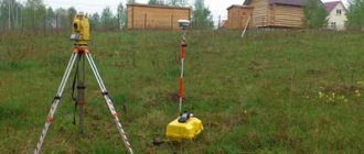
The responsibility for monitoring the extreme points of land plots is assigned to cadastral engineers. These are highly qualified specialists who have the necessary professional knowledge and have the appropriate government certificates.
The list of powers of cadastral engineers includes:
- the right to familiarize yourself with documents certifying the identity of land owners;
- the right to inspect title papers;
- the opportunity to provide land owners with a boundary plan and give the necessary explanations on it;
- establish the boundaries of land plots subject to approval;
- carry out the actual coordination activities.
Procedure
Land surveying can be carried out by either a private or government specialist. A prerequisite is that he has a special certificate for carrying out activities.
In 2021, there is a special service where you can check whether an engineer has access to this type of work.
When checking information about an engineer, you need to pay attention to the number of refusals to register a site based on his documents. The higher the level, the less reliable the specialist is.
Algorithm of actions when surveying a site:
- Collection of documentation.
- Coordination with neighbors.
- Carrying out land surveying.
- Registration of land surveying.
- Getting the result.
Important! The land surveying procedure is of a paid nature. Regardless of whether a private or public organization is chosen, the customer is obliged to pay for the services of a cadastral engineer.
Collection of documentation
Only a person who has legal rights to the site can order a land surveying procedure. This may be the owner, the tenant, a person who owns the object on the basis of the right of use or lifelong inheritable possession.
An alternative option is a proxy. But in order for another citizen to represent the interests of the owner in government agencies, it is necessary to issue a notarized power of attorney.
If you do not have enough time to carry out land surveying, you can involve a lawyer. The specialist will visit the authorized bodies, collect consent from neighbors, and discuss controversial issues.
List of documents for land surveying:
- owner's civil passport;
- title document;
- cadastral passport or land plot plan.
If a representative acts on behalf of the owner, then you will additionally need his passport and a notarized power of attorney.
The cadastral engineer has the right to request from the owner information about the absence of underground communications and electrical cables on the site.
Land surveying procedure
| No. | Stages of the procedure | Comments |
| 1 | Preparation of documents | Documents are provided in the form of originals. Copies are made by a specialist independently. |
| 2 | Selection of cadastral engineer | When contacting a government organization, the cost of the service will be significantly lower, but the waiting period may be several months. A private company will prepare documents as quickly as possible, but the cost of services will be higher. |
| 3 | Conclusion of an agreement | A cadastral engineer carries out activities on a contractual basis. The document will contain all the rights and obligations of the parties. It must be preserved for as long as possible. If violations are detected, it will be possible to recover compensation from the engineer. |
| 4 | Notifying neighbors | Neighbors must not only agree to the land survey, but also be personally present during the procedure. They need to sign the corresponding document. |
| 5 | Site visit by engineer | The cadastral engineer is required to personally visit the site. During the inspection, boundaries are measured and the coordinates of boundary markers are established. |
| 6 | Preparation of land surveying | The result of the inspection and measurements is the registration of a survey document. The document is issued in paper and electronic form. |
| 7 | Getting the result | The document is issued to the customer within the time limits established by the contract. |
How does approval take place?
The process of coordinating the extreme points of the sites can be carried out in one of two options. The first implies that the stakeholders are several people at once. The second involves individual coordination with one neighbor.
A corresponding notification is sent to each of the parties directly related to the case a month before the event. It must be handed over only against signature.
Electronic notification or publication in the media is also permitted. True, these two methods do not guarantee that the information will reach the recipient.
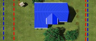
On the appointed day, the cadastral engineer takes measurements of the plots and installs special identification poles at the required points. They must contain information about the number and date of installation. Supervision over the condition of these pillars rests with the land owners. In case of damage or loss, the violator may be subject to administrative punishment in the form of a fine.
The entire process is recorded in a special approval act. This also includes information about whether the participants in the process agree with the established boundaries or not.
With the administration
When carrying out an approval procedure affecting neighboring lands owned by municipalities, it is necessary to carry out an approval procedure with the administration. The legislation provides for compliance with certain standards, which include:
- participation in the preparation of the cadastral engineer’s approval act;
- personal information by the cadastral engineer to an authorized person with an explanation of the rules and regulations of the calculations made;
- obligation of an administration representative to participate in the border approval procedure;
- refusals are issued in a form according to the approved sample with motivation according to the approved list;
- · controversial issues must be resolved during court hearings.
With forest fund
The need for coordination with the forest fund may arise due to the passage of the boundaries of the site next to the territory belonging to the Leskhoz. Since the systematization of cadastral registration by the forest fund has a number of disadvantages, the approval process can be labor-intensive and lengthy. In particular, in this regard, a draft of the so-called “Forest Amnesty” was prepared, according to which it was proposed that all plots registered in the territories of villages located in the forest be re-registered as private ownership of residents.
Features of drawing up an act
Today there is no generally applicable, standard form for the act of agreeing on the boundaries of a land plot, so it can be written in any form. The only thing that needs to be taken into account is that the sequence of its content meets certain standards for compiling this kind of documentation. This means that the form should be divided into three parts:
- beginning is the name and number of the document;
- main section - information about the site, the boundaries of which are being agreed upon;
- conclusion - the decision made (whether they were agreed upon or not) and the signatures of the parties.
The act can be written manually or typed on a computer. For a printed document, an ordinary blank sheet of paper of any convenient format is suitable (A4 is mainly used).
The document must be made in a number of copies equal to the participants in the approval procedure - one for each interested party.
How to coordinate land surveying with neighbors
An important stage of land surveying is the coordination of boundaries with neighbors. If the opinions of neighbors are not taken into account when drawing up a boundary plan, then interested parties may challenge the boundaries of the site.
Consent must be obtained from all legal owners of plots that border yours. These include citizens and legal entities who own land by right:
- property;
- lifelong inheritable ownership;
- unlimited use;
- lease (if there is a contract for a period of 5 years).
Notification is sent 1 month before the work is due. It is advisable to send information in a way that allows you to record the fact of receipt of the document (registered letter, telegram).
If the whereabouts of the owner are unknown, then a publication in the media can be used as a notification.
Each notice is issued in 2 copies. One is sent to the addressee, the second is filed in the boundary file.
Sample act of approval of the boundaries of a land plot
- First, in the middle of the document, write its name and put a number (if necessary).
- Next, the cadastral number of the plot, the boundaries of which are being agreed upon, its area is indicated, and information about the owner is also given.
- After this, information about the approval is entered into a special plate:
- a sign indicating the demarcation is indicated;
enter the number of the adjacent plot and information about its owner;
- a note is made if the agreement took place with a person acting under a power of attorney;
- signature of the owner of the neighboring plot.
- Further, the act must include information that there are no disagreements regarding the agreement between the owners of neighboring plots. If there were any, this must also be indicated and at the same time write down what decision was made in this regard (trials in court, voluntary additional land surveying, etc.).
- At the end, the document is signed by all participants in the approval procedure.
You can add any other additional information to the table as needed.
Notification of neighboring property owners
Once the approximate day for the survey has been set, it is required to notify all owners of land plots bordering the given one .
The law sets a time limit for notification: it must be sent no later than 30 days before the expected day of approval.
You can notify your neighbors in several alternative ways:
- Notify by registered letters with notifications . The places of residence of neighbors can be found out in the cadastral service. It is advisable to use this type of notification when there is confidence that the citizen will not sign the notice, and therefore the act of approval. Therefore, it is advisable to send three letters to the neighbor, since a letter sent three times in the name of one person becomes a basis for believing that the signature of this person received.
- Personally deliver the notices to each of the recipients, receiving his signature. If there is no signature, it will be impossible to prove that the neighbor was not served with a notice.
- Send an email (with a read receipt). This type of notification is the least popular, since not everyone has an email and email addresses are not publicly available.
- Publish an ad in the local press . This is usually practiced if the place of residence of a neighbor cannot be determined, or when delineating plots located within a gardening and dacha partnership.
A notice sent to a neighbor can be written in free form (a sample can be viewed and downloaded via the link), but it must include the following information :
- The notification begins with an address to this specific citizen indicating his full name.
- Next, enter the full name of the person requesting the procedure, his address and telephone number for contacts.
- The data of the cadastral engineer, his full name, address, telephone number are recorded.
- The address of the actual location of the site and its cadastral data are indicated. If there is no address yet, the block where the site is located is indicated.
Information about adjacent areas is included, with addresses and exact numbers. At the end, the time and place of the planned coordination and ways to obtain information about the procedure being carried out are indicated.
What is it and when is it signed?
Coordination of the extreme boundary of the site is considered an element of land surveying, which determines the right and regulations for the use of the owners’ border areas. It is considered the result of boundary actions. In other words, this is a coordination of the location of the land with neighboring lands, taking into account the documents and not to the detriment of any of the land owners.
To carry out this procedure for establishing boundaries, you must contact the cadastral authorities. They carry out the official establishment of the actual boundaries of the site. An indispensable requirement for determining boundaries is imposed for the following types of land:
- To areas included in the cadastral register.
- On the lands where the work of cadastral specialists is carried out.
- In areas where there is a need to establish actual boundaries.
The approval process certifies the implementation of cadastral work and confirmation from the owners of adjacent land plots in the form of consent signatures in the document. After the boundaries have been detailed, the document drawn up by the cadastral specialist will already have legal force, as well as the definition of legal standards.