Pravozhil.com > Real estate registration > Land registration > How many acres can be attached to a land plot - registration procedure
In 2014, significant changes occurred in the land legislation of our state. They allow owners of plots of land acquired for various purposes to increase them by annexing additional territory. How many acres can be added to a plot of land?
Read about this, as well as whether this procedure involves the payment of various fines and additional funds, in this article.
What is land redistribution or adding someone else’s land to the main one?
Redistribution of a land plot (in common parlance “Prirezka”) is an increase or decrease in one’s land plot at the expense of the state or the land plot of another owner.
In the Land Code, this norm is enshrined in Art. 39.28 and art. 39.29 of the Land Code of the Russian Federation. However, please note that as a result of land redistribution, the area of the plot cannot exceed the maximum maximum size established by the rules of land use and territory development within the urban planning zone. You can view the urban planning zone, as well as the land use and development rules (PLZ), on the official website of the administration of your municipality. The above norms apply to areas owned by citizens and bordering state and municipal ones. The territory of land at the expense of which redistribution is carried out cannot be a public territory, and it also cannot go beyond the territorial boundaries that denote communications, roads and other linear objects.
- Clause 3 art. 39.28 of the Land Code of the Russian Federation stipulates in relation to which plots the increment is provided - excerpt from the article - redistribution of lands and (or) land plots in state or municipal ownership, and land plots owned by citizens and intended for personal subsidiary farming, vegetable gardening, horticulture , country houses, individual housing construction.
- The procedure for submission and list of documents is specified in Art. 39.29 of the Land Code of the Russian Federation, in addition, clause 9 of Article 39.29 of the Land Code of the Russian Federation contains a list of grounds for refusing to provide an “extra allowance”.
- The procedure for registering the “addition” is carried out on the basis of an agreement between the citizen and the authorized body for a fee, while, with a positive decision of the authorized body, the citizen must organize and pay for the work on cadastral registration of all land plots that are formed as a result of redistribution - clause 11 of Art. . 39.29 of the Land Code of the Russian Federation.
There must be compelling reasons for land redistribution. These include:
- combining plots into a single land mass with a common purpose or land surveying (cutting);
- seizure of land by the state for the implementation of special functions;
- but the most common reason is to clarify boundaries in the event of disputes with neighbors.
Article 11.2 was adopted as the regulation. Land Code of the Russian Federation, which identifies the following options for the formation of land plots:
- chapter;
- Union;
- redistribution;
- allocation from other areas, as well as state lands.
Since, as a result of changes, some units of land law cease to exist, while others appear, the procedure affects the interests of several individuals and legal entities. From this we can conclude that the redistribution of land plots is a legally significant procedure, as a result of which new units are formed from several plots located nearby.
Please note that only land plots with the same type of permitted use and intended purpose can be combined.
What is “cut-in”, legislative framework
Cutting is the unauthorized addition to an existing plot of part of the plots located nearby. The owner moves the established boundaries, thus increasing the total area of his main plot. Often people do this without permission, so the legislation had to create special regulations that could regulate this procedure.
The Land Code has undergone a number of amendments, which on March 1, 2015 gained the necessary legal force. The new Land Code of the Russian Federation has an additional chapter, which describes in detail the process of cutting and subsequent registration of plots acquired previously without permission; this is chapter V4. Its name, “Redistribution Procedure,” specifically refers to the possibility of adding additional acres to your existing territory. Citizens will need Article 29.29.
How to check a plot of land before cutting
In order not to guess whether your land redistribution will be satisfied or denied due to restrictions unknown to you, a new electronic service for preliminary verification of land plots has been launched for the Moscow region. It is designed for tenants who are going to formalize the addition of someone else's land plot to the main one.
The service allows citizens to learn about almost all existing restrictions on the use of land in advance. For this:
- In the “Land and Construction” section on the regional government services portal you need to find;
- Select a municipality and indicate the cadastral number or coordinates of the territory you are interested in.
- After this, information will become available about whether your land plot is included in a forest, security or airfield zone, as well as a short summary, for example: construction on this territory is prohibited. In other words, you are notified of possible problems even before you apply for the transfer of ownership of the site.
We are waiting for such a service to start working all over Russia...
Administrative punishment
Responsibility for cutting off land will depend on the category of the person who illegally took possession of the land:
- legal entity – 2-3% (but not less than 100,000 rubles);
- official – 1.5-2% (at least 20,000 rubles);
- individual – 1-1.5% (not less than 5,000 rubles).
In the event that the assessment of this land plot has not been carried out, the fine will have a fixed amount:
- legal entities – 200-300 thousand rubles;
- official - 40-50 thousand rubles;
- individual – up to 10,000 rubles.
How to formalize an agreement on the redistribution of land between owners
Step 1 - Assess the chances and risks
First, study the documents on the redistributed plots. Request information from the State Real Estate Cadastre in the form of an extract from the Unified State Register of Real Estate. The main thing is to find out whether the plots belong to the same municipality and confirm the fact of their contiguity. Only in these cases does it make sense to start the procedure.
If, during redistribution, one of the owners receives a reduced plot, he is paid compensation specified in the agreement. I recommend that you agree on this point in advance with all parties to the agreement.
Step 2 - conclude an agreement between the owners
Since several individuals are involved in the procedure for dividing a land plot between owners, all work begins with the conclusion of an agreement. If there is no such document, then this is a slightly different judicial procedure. The number of persons participating in redistribution is not limited by law.
An agreement on the redistribution of land plots between owners must contain the following information:
- Information about the owner of the land plot: full name, passport details, residential address;
- Data on the land plot undergoing redistribution: area, location, cadastral number, category of land, date and place of registration of rights to real estate, identification data of the certificate of registration of ownership;
- Data on new land plots transferred to the owners of previous lands. The same standard characteristics are indicated as for the previous sections. If several land units are transferred, then all information on each of them is provided.
.
Required documents
To carry out the process, you must provide the following documents:
- civil passports of the applicants;
- agreement on annexation of additional area;
- application to the registration service;
- technical information on objects;
- title documents for land property.
How to formalize the redistribution of a land plot with municipal lands
The addition of a land plot is carried out through the purchase of ownership, i.e. you buy part of a neighboring plot and, at the expense of this part, increase your plot (“Redistribution of a land plot, Art. 39.28, 39.29 of the Land Code of the Russian Federation”). The amount of payment for the land plot that you want to add to the existing one is set by the owner of the land - the state, a subject of the federation or a municipal entity, depending on its ownership (Clause 5 of Article 39.28 of the Land Code of the Russian Federation). To calculate the final price of the land plot to be cut, it is enough to know its area, cadastral value and the amount of the fee for the cut, which is set by the owner of the land as a percentage of its value.
As a result of the redistribution of a land plot, a new, enlarged land plot is formed. The maximum dimensions of the area of part of the land plot are determined in accordance with Art. 33 of the Land Code of the Russian Federation, maximum (maximum and minimum) sizes of land plots. If your area's PZZ is approved, the provisions specified in this PZZ apply. I think if there is such a clause in the PZZ, then the maximum size of the extension will be no more than 100 sq.m. (1 hundred square meters).
The agreement is drawn up between the owner of the land (municipalities, entities) and the owner of the plot that is being increased. The latter submits an application to the district administration for redistribution of the land plot. The period for consideration and decision making is 30 days.
The following must be attached to the application:
- Extract from the Unified State Register of Real Estate for your land plot. Please note that in Rosreestr an extract from the Unified State Register costs 350 rubles (700 rubles for legal entities). If you want to get information cheaper, I recommend ordering a certificate through Quick Documents - this way you will receive a document for only 250 rubles. The order is completed within a day, the official data is from the Unified State Register of Russian Registers of Rosreestr.
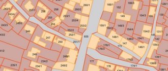
- A diagram of the planned site on the cadastral map. You can order a plot layout diagram without leaving your home. To do this, I recommend the ONLINE CADASTRE service, which sends a document ready for redistribution within 2 days. Cost - 2400 rubles, official data and compiled by a cadastral engineer in accordance with Resolution No. 762 of the Russian Ministry of Economic Development.
Layout of the land plot, which I recently ordered through the ONLINE CADASTRE
When the new layout of the landfill has been agreed upon, land surveying can begin. To choose a competent contractor, I created instructions for land surveying.
Within 14 days after payment, your land plot will begin to appear on the public cadastral map. If everything is done correctly and your intentions do not run counter to the law and the intentions of the state, you become the owner of the new plot.
What to do if they want to reduce the area of your land plot
How much does it cost to register land acquisition?
The procedure is not carried out free of charge. According to the Land Code of the Russian Federation, a citizen, in addition to the state duty, pays separately for the addition. How much will it cost approximately? The price is determined individually; it is 15% of the cadastral value indicated in the documents.
In addition, the citizen who made the cut still needs to re-land survey, the cost of which is fully paid by him. As a rule, the price of such work is determined by the cadastral organizations themselves. By the way, you can order a detailed plan with detailed video shooting or a regular paper version. Experts advise choosing the first one. This way you can better see the location and number of all signs being installed, as well as their coordinates.
Is it possible to trim the same section in several stages?
Let’s say there is a state-owned plot adjacent to the land you own, which is not registered in the cadastral register. Is it possible to make an addition to a state plot within 10%, and then repeat the procedure until the state land plot is completely “exhausted”?
Personally, I don’t see anything illegal in this. However, it is better to resolve this issue specifically on the spot and with a cadastral engineer. The owner of the land plot can determine the fate of this land plot in any way not prohibited by law, namely: increase, decrease, divide, allocate, donate, sell, etc. The only thing that should be taken into account is that the site being formed does not exceed the permissible area limits (see the PZZ of your municipality), and also corresponds to the type of its permitted use.
Sanctions for illegal land seizure
Cases of illegal seizure of land are established by Art. 7.1 Code of Administrative Offences . If fraudulent aspects are identified in this particular case, the case may fall under the criminal code. In this situation, the offense faces much more serious consequences than just a fine and seizure of the site.
If there are no fraudulent actions, the violator will pay a fine. Its size depends on several factors:
- whether the plot is registered in the cadastral register;
- What is the estimated value of this plot of land?
Grounds for refusal to redistribute land
The grounds for refusal to conclude an agreement on the redistribution of land plots are the inconsistency of the submitted application with cases of redistribution of land plots, which are provided for by law:
- lack of consent of third parties, stated in writing, if the cut-off area is burdened with their rights, for example, a mortgage from a bank that requires approval from it; on the cut-off site there is a building or structure, an object of unfinished construction, owned by the municipality or the state, or owned by citizens or legal entities;
- the cut-off area refers to municipal or state lands withdrawn from circulation or limited in circulation; the cut-off area refers to lands reserved for state or municipal needs;
- for the cut-off area, a decision has been prepared to hold an auction with the publication of a notice of the holding and preliminary approval for its provision has been completed and the validity period of the decision has not yet expired; another application for preliminary approval for its provision has already been submitted for the cut-off area, but decisions have not yet been made either in agreeing and approving the layout scheme, or in refusing (as many like to say, “whoever stood up first, got his slippers”);
- the area of the cut-off plot will increase the area of the one formed by its merger with the main one, exceeding by more than 10% the established size of the maximum areas of land plots; the cut section cannot be considered as an “additive” and must be formed as an independent one;
- the boundaries of the main area to which the extension is planned require clarification, that is, if the main area is not demarcated; inconsistency with the layout of the land plot.
How much land can be annexed
Many people are concerned about how exactly the redistribution procedure occurs. Does a person simply select the desired amount and “cut off”? No, the RF Land Code specifically states how much land can be added to the main plot. If the maximum quantity specified there is exceeded, then such an object cannot be registered.
Simply put, the plot being cut, in principle, should not be larger in size than the area where it is being cut. Most often it is 5-6 acres. However, each region sets the maximum size independently. It is necessary to clarify the information with Rosreestr or the cadastral organization.
What to do if land redistribution in Moscow is refused
In the Moscow region as a whole, there is now a pronounced problem with increasing land plots due to redistribution (additions). First of all, I recommend having on hand any documents related to the land, as well as answers to your requests to the Administration. It would also be a good idea to have a land lawyer (unfortunately, in Moscow this is difficult or quite costly and not guaranteed).
Next you can try the following:
- If the land plot is without land surveying, then first you will need to do a land survey and only then deal with the issue of registering an increase in the area of the land plot.
- Without a territory surveying project (TMP), it will not be possible to formalize the addition of a land plot on the territory of Moscow or New Moscow. Development or adjustment of PMT is a mandatory stage. To do this, it is necessary to prepare a layout diagram of the land plot, which displays the original land plot + the one to be cut + geodetic coordinates. After receiving the Order to develop a PMT, it is necessary to develop a PMT. The development of PMT is carried out by cadastral engineers or Moskomarkhitektura.
- Next, contact the Moskomarkhitektura to approve the developed PMT, contact the DGI and the district commission.
- Next are public hearings, again the DGI for the final approval of the PMT and receipt of the Order, as well as the approved PMT itself.
- Next, cadastral work is carried out with an application to the DGI for an order on the formation of a land plot by redistributing boundaries on the basis of the PMT, the formation of a boundary plan, and an appeal to Rosreestr with an order from the DGI.
- After which, with the received extracts, you contact the DGI for redemption of the memory.
Trimming or self-grabbing?
You can use the land only if it is legally registered . If a citizen disposes of a land plot without any grounds for doing so, this is called squatting.
Until the boundaries of the site are determined and rights are registered, any manipulation on this land is illegal.
The offenders in this case can be both officials and ordinary citizens . The legislation provides for a number of sanctions that can be applied in this case to a citizen who has violated the procedure for appropriation at the expense of public lands. In addition, the illegally appropriated land will have to be returned.
Arbitrage practice
The Supreme Court clarified the rules for dividing land plots in cases that most often occur (during divorce, receiving an inheritance, etc.). In these situations, the size of land plots after the division process is of great importance. According to the law, the owner can receive his plot only if all the shares received after the division meet the established standards for the intended use. For example, dividing a garden plot can only be done if in the future all parts can be used for the same purpose.
Explanations of the correct division of land were given when the judicial panel for civil cases of the RF Armed Forces reviewed a land dispute that occurred on the territory of the Volgograd region. The essence of this case is as follows: a citizen decided through the court to obtain the allocation of part of a plot of land and a house, which were in common ownership of several people.
The plaintiff owned 2/3 of the land and home ownership, and the other 1/3 belonged to the woman. After the death of the owners, its part passed to the heir. According to the BTI passport, the area of the plot was 506 sq.m., and the house - 70.1 sq.m. This land was intended for horticultural purposes, therefore, when dividing it, it was necessary to comply with the permissible parameters for the continued use of the shares for the same purpose. However, the heir was not satisfied with such a division, and he filed a counterclaim against the plaintiff in order to divide the property according to his own version. But the court decided in favor of the plaintiff, giving him 337.3 sq.m. land, and the heir - 167.7 sq.m. The same decision was upheld on appeal.
When making such a decision, the Volgograd local court relied on ownership shares, but the Supreme Court did not agree with this. He explained his decision in Article 1. Land Code. It states that the division of plots owned by several people at once can be carried out using different methods. New plots can be allocated from existing ones or redistributed from existing plots, as well as sold or given away. The division of shares is also the allocation of a plot. At the same time, both the new and the remaining parts continue to be considered sections, but with new boundaries. The owner of the allocated share becomes the full owner of the individual plot, and the owners of the remaining parts of the plot remain the owners of shares of the common property. However, despite the methods of division, the original intended purpose of the land and all parts separated from it must be observed. The law also stipulates the maximum and minimum sizes of new plots.
In 1996, a plenum of the Supreme Arbitration and Supreme Courts was held, at which the Civil Code was discussed. Article 252 of the Civil Code of the Russian Federation states that the court may refuse to divide common property according to shares, if in this case all the resulting plots cannot continue to be used for their intended purpose. In this case, it is considered that the common property is damaged.
The Supreme Court clarified that the same thing is recorded in the Law “On the State Real Estate Cadastre”. It says that the cadastral authority may refuse to register a land plot if the divided shares do not correspond to the sizes specified in the law (minimum and maximum). Based on the above laws, the Judicial Collegium for Civil Cases comes to the conclusion that the allocation of a part of a land plot that is in common ownership is possible only if the intended use and permitted areas are observed during the division.
The Land Code states that the minimum and maximum sizes of plots can be established only by town planning regulations. And the Town Planning Code states that the size and rules of land use are established by local authorities. In the case discussed above, it was necessary to rely on the resolution of the Volga City Duma of the VO, according to which the maximum plot size can be 0.2 hectares, and the minimum - 0.02 hectares. That is, the part of the land allocated to the defendant with an area of 167.7 sq.m. does not comply with this resolution. This became the reason for the review of this land dispute by decree of the Supreme Court of the Russian Federation.
Return of illegally occupied lands
In the event that a citizen has encroached on a land plot owned by another person, it is necessary to influence him by legal means.
What to do in this situation:
- First of all, it is necessary to notify the citizen who has occupied territory that is not his own of the fact of violation.
- Be sure to find out how he motivates his actions; it is quite possible that in this case a fraudulent scheme was used, according to which the citizen simply falsified documents on the property, arbitrarily attributing to himself additional acres of land.
- If the invader acts confident enough, try to convince him to change his mind by presenting your documents for this plot.
- If your own forces are not enough to solve the problem, and you cannot free the unauthorized territory on your own, you need to contact the local administration, which will help set all the accents.
- The second option is to go directly to the court, but before that you need to request from the administration a copy of the protocol of the administrative commission, which in this case should have been collected.
How to resolve a land dispute between neighbors: step-by-step instructions
Before the conflict comes to court, the parties (or at least one of them) try with all their might to resolve it on their own. Sometimes this does not make any sense and it is better to immediately start preparing a claim, but in some cases you can achieve protection of your rights without going to trial.
1. Determining your position and causes of the conflict
Understand what your or your neighbor's complaint is and what it involves. If there is an error in the documentation, request the correct document, if possible. A cadastral error, for example, cannot be corrected with a simple request - you will still have to go to court.
In cases where the cause of the conflict is personal interest or “working on principle,” take an interest in legal information and first consult with a lawyer. Ideally, a written opinion from a lawyer. If the subject of dispute is only the boundaries of the site, conduct a joint survey that will help establish or restore them.
2. Sit down at the negotiating table
It is better to start resolving any conflict with negotiations. Abstract from emotions and try to calmly, without swearing, talk about the causes of the problem and options for solving it. Explain to your neighbor that escalating the conflict and bringing it to court is fraught not only with significant expenditure of time and money, but also with a not always predictable result. Provide your lawyer's arguments as support.
3. Involve the municipality in resolving the dispute
Each municipality has a number of different departments and commissions that can help resolve the dispute.
For example, the administrative commission monitors the implementation of regional laws, landscaping rules and other norms, and therefore can hold a neighbor accountable for any violations - for example, storing building materials on the boundary of the plot in front of the neighbor's house.
The land department of the city government (the department itself and the positions of its employees may have different names), responsible for considering complaints from citizens on land management issues, can give a written opinion on your appeal regarding the conflict.
Almost always, specialists will go to the site, inspect problem areas and give their recommendations for resolving the dispute.
Alas, unlike a court decision, even the conclusion of municipal authorities based on the law is not unconditionally binding on the conflicting neighbor. If all else fails, get ready for trial!