Home / Real estate / Land / Land survey / Cadastral passport
Back
Published: March 18, 2017
Reading time: 10 min
0
1521
In the Russian Federation, the issue of land ownership has always been extremely acute for the public and the state, since there is a lot of land and it needs to be used correctly.
Despite the fact that the legislation quite comprehensively describes all the rights and obligations of owners and lessors of land plots, land disputes still break out from time to time between the owners of neighboring plots.
In our article we will describe in detail the legislative norms that affect the issue of land surveying, and also explain whether it is necessary to carry out land surveying if you already have a cadastral passport.
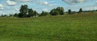
Land surveying is a procedure carried out by cadastral engineers to accurately determine the boundaries between land plots. Land surveying is closely related to geodesy, which is carried out on various plots of land.
Cadastral passport is a document with technical characteristics that is issued to the owner of a land plot when the plot is registered with the state.
Old cadastral passports do not always contain data on the survey carried out, because previously, according to the law, they were issued without this procedure. In the future, this led to frequent confusion with the imposition of one land border on another and, as a consequence, land disputes.
- Legislation
- Is it necessary to carry out land surveying if a cadastral passport has already been issued?
- Why carry out land surveying if the cadastral passport was issued earlier?
Reasons for not having established boundaries
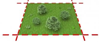
There are several reasons why land surveying was not carried out on the site. This procedure involves establishing boundaries on the plan and on the ground, creating a boundary file, which will include a description of the land plot and its drawing. After which all survey results are included in the state cadastre database .
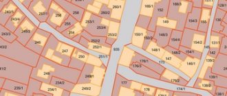
The demarcated plot will be registered in the cadastral register and can be found on the public cadastral map. If you look closely, you can see that there are areas on it that do not have coordinates. This means that the owner of the plot did not carry out land surveying, although the plot has a cadastral number and an owner.
Land surveying was not carried out for the following categories of citizens:
- Summer residents . There are still dacha plots whose owners prefer not to carry out this procedure. Most often this is explained by high prices for ]cadastral engineers[/anchor]. Sometimes problems arise due to unauthorized “cuts”, when part of the land in use is not documented in any way. But, in general, the dacha amnesty allows you to register a dacha plot using a simplified system.
- Persons whose rights to plots arose on the basis of perpetual use . The peculiarities of such ownership are the absence of the right of transfer by inheritance, donation and sale of land. Such a site can be registered using a simplified system, but land surveying will allow more precise boundaries to be drawn.
- Citizens who bought a plot without land surveying. Most likely, the previous owners registered the allotment in the same way, taking advantage of the law on dacha amnesty.
The following reasons are also possible:
- The site has been allocated by the local administration for some program (for example, assistance to large families). Here land surveying is a matter of time. Typically, new owners try to obtain all documents for registering property rights as soon as possible.
- The site may not be on the cadastral map due to the fact that the documents were not submitted to the state cadastre . The land surveying procedure was carried out in full.
In these cases, it is enough to contact Rosreestr with documentation or carry out the survey again.
There are plots whose market value practically does not exceed the costs of land surveying and registration of the plot. In this case, the owners prefer not to register the land.
How to properly set land boundaries?
This is done in several ways:
- According to visible restrictions: pegs, posts or fence surrounding the site. Based on this data, documents are verified and further confirmed;
- According to the location of neighbors' fences . This option is not always reliable, but it is the fastest;
- Using the existing cadastral number or through the Rossreestr website . The documents must display coordinates, area and attach a plan or sketch. To view Rossreestr information, just go to their website, find the “Public Cadastral Map” tab and enter the number of your plot;
- The boundaries are re-established with the help of a third party company.
Is it possible to register land as a property without land surveying?
Land registration involves several stages :
- submission of all documents to Rosreestr;
- writing an application;
- payment of state duty.
The presence of a boundary plan or cadastral passport will make the registration complete . That is, all information about the site, the coordinates of its boundaries and the boundary plan will be in the Rosreestr database. When selling a plot, the buyer will know exactly its characteristics.
How to register a plot of land for cadastral registration
In order to register a plot of land for cadastral registration, you need to provide a package of documents to the state cadastre department at Rosreestr. Cadastral registration is the entry of information about any property, including land plots. To collect this information, a specialist must go to the site .
The cadastral engineer determines the coordinates of the land boundaries and registers all the information received in acts and other documents that are submitted to Rosreestr. Then the documents are processed and the plot acquires a cadastral number. And all other data is entered into the database.
Read more about cadastral registration here.
How to get a cadastral number
The presence of a cadastral number indicates that the land plot is registered in the cadastral register . All documents relating to this site have a cadastral number. With it, any property can be identified faster and easier, since it is not repeated anywhere.
A unique cadastral number can now be obtained not only after the land surveying procedure. Read more about obtaining a cadastral number here.
But there are exceptions. There are a small number of sites left that are registered in various information systems.
But at the same time, the citizens who are the owners of this land have not officially registered their ownership. We are talking about plots with the right of permanent, unlimited use.
The issuance of a cadastral passport for a land plot was possible without land surveying. In this case, the document contained a note that “the boundaries were not established in accordance with the requirements of the law.”
Obtaining a certificate of ownership
A certificate of ownership of a land plot could be obtained without land surveying.
Owners often have a question: do they need to do it now if they already have a document?
Using the services of a cadastral engineer and determining the coordinates of the boundaries of a plot is sometimes forced by the wishes of the buyer, who wants to know exactly what he is buying.
Rosreestr stopped issuing Certificates printed on stamp paper in 2021.
Now an extract from the Unified State Register serves as a document confirming ownership. It is printed on plain paper, A4 size.
Now Certificates are not issued, and acquisition of property rights is impossible without land surveying . This means that it will not be possible to bypass this procedure when purchasing a plot.
Consequences of unformed site boundaries
So, a land plot without coordinates is a territory that does not have a clear definition of its extreme points.
For the information of owners, setting boundaries independently does not guarantee their correctness. The fence may stand on a neighbor’s land, a private road, or occupy part of a municipal territory, for which you will subsequently have to pay a fine of 5 to 100 thousand rubles.
To determine the boundaries and so-called corners of the site, it is necessary to have a special cadastral engineer who takes measurements, determines the position of the site, and its coordinates on the map.
Before calling a specialist, you need to collect information about neighboring plots, coordinate the boundaries in such a way that there is no “overlap” of land on neighboring plots or, conversely, ownerless areas.
Errors in the cadastre
Sometimes, when registering a cadastral number, mistakes are made, either accidental or intentional, such as a neighbor’s unauthorized expansion of its borders. Such errors must be corrected immediately in order to avoid controversial issues in the future, when selling or renting out land.
Incorrectly entered data may be:
- technical;
- cadastral.
The first ones arise due to the fault of a cadastral chamber specialist, due to typos, incorrect entry of a surname, numbers, etc. The second is initially incorrectly submitted data, which is an illegal action.
Technical errors
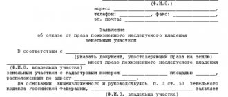
They are eliminated by the specialists themselves upon detection, or at the request of the applicant, who needs to write appropriate statements to the cadastral chamber and the MFC, indicating in them:
- Last name, first name and patronymic of the owner, as well as his details: passport details, addresses, telephone numbers;
- If the applicant does not apply for corrections in person, then information about his representative is also required;
- A table is filled in, in which the first column indicates the name of the object and the error. In the second, the problem itself is described in detail, and in the last, the correct version of the outcome of the case.
Along with the application, a document with reliable information is submitted. This can be done in person or by sending papers by mail or through online resources.
Within 5 days, the Cadastral Chamber reviews and studies the application and, based on data analysis, gives an answer as to whether the documentation will be adjusted.
If the decision is positive, the owner will receive a new passport for the land. Otherwise, he will be provided with comprehensive information about the refusal. The reason for this may be:
- Incorrectly completed application or lack of confirmation of the problem;
- There is no error, perhaps the cadastral chamber already stores the correct information;
- The reason for refusal may be the identification of a non-technical error.
Cadastral errors
These are much more difficult to fix than technical ones. The process of verifying the authenticity of information and proving that the plaintiff is right can take quite a long time.
Such errors include:
- Incorrectly carried out surveys;
- Incorrectly specified addresses;
- Problems with documents establishing the type and category of land.
- Violations associated with the construction of a house.
To correct these errors, as in the previous version, you should submit an application and an attached document with the correct information to the registry office or the MFC.
There are cases when it is impossible to attach papers, because an error was made within the walls of the Cadastral Chamber or a dispute arose due to the determination of coordinates. In this situation, first, you need to go to court. And only by his decision is it possible to obtain a new cadastral passport.
Changes to the registry usually occur within 10 days. The chamber staff themselves may notice the mistake. Then they eliminate it on their own, and only pass on the relevant regulations to the owner and government agency about the need to eliminate the inaccuracy.
What to do if the coordinates of the site are not established?
If there is no information about current boundaries, you must use the last item in the previous list and invite an engineer to measure the area.
The process of setting boundaries takes place in several stages:
- A specialist is invited to carry out land surveying and an agreement is concluded with the relevant company providing services for geodetic work;
- The division of land is agreed upon with the neighbors and an agreement is signed. If relations with neighbors are established and there is a common fence across the territory, there will be no problems. However, it often happens that there are serious disagreements between the owners of neighboring plots. In this case, you will have to formalize the borders and coordinates through the court, where you can prove your case;
- Upon arrival of the engineer, for measurement, a land surveying case is opened in two copies, one of the documents is sent to the cadastral chamber, and the other is retained by the owner. The surveyor carries out the entire range of measurements and links the site to coordinates;
- Next, you need to contact the Registration Chamber with a written application, attached documents and wait to receive new papers.
In the best case scenario, the entire procedure will take no more than 1-1.5 months. If agreement with neighbors is not reached, the matter may drag on for months, or even years.
How to check the qualifications of an engineer?
It is extremely important that the specialist who arrives on site is sufficiently experienced, qualified, responsible for his work, and does not disappear immediately after the provision of services. Otherwise, if there is an error in the documents, you will have to call another contractor and again bear the cost of paying for his labor.
On July 1, 2021, new provisions of the law came into force that tighten the requirements for surveyors. In addition to mandatory specialized education and a minimum of two years of internship, they must join a self-regulatory organization (SRO). This organization monitors the activities of all registered employees and, if shortcomings and errors are detected, corrects them.
Anyone can check the qualifications of an engineer. To do this, you need to enter information about the specialist (full name) on the Rosreestr website in the “Register of Cadastral Engineers” tab, after which detailed information about him will be displayed, including certification and results of professional activities.