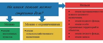
The territory of the country is divided into lands:
- settlements;
- agricultural purposes;
- natural reserve areas;
- forest lands;
- water spaces;
- special purpose;
- stock.
Read more here: 7 categories of land, their codes and intended purpose.
Theoretically, the entire territory is divided into plots and a category is defined for each, since it is this that is the basis of accounting information about the land.
But in reality, it is often discovered that there are unzoned arrays or that this characteristic is missing from the documents. This defect must be corrected as quickly as possible.
How can I find out from the documents?
The definition of the category must take place in any official documents that talk about land as an object of law. There are a lot of them.
- Documents of power structures of various subordination: federal, regional (regional), municipal - on the allocation of land for the individual needs of citizens. A typical example is a document of ownership of allocated land.
- Agreements on the purchase and sale of land, its exchange, lease, etc.
- Information from the State Real Estate Cadastre: passport, extract, Unified State Register of Lands and others.
- Document on state registration of rights to real estate. The main characteristics of the land are also indicated here.
- Other official documents in which the area of interest appears. Let's say, an act on the seizure of land due to its inappropriate use, etc.
The documents that the owner has must duplicate all other official information.
If the category is included in the owner’s papers , but there is no mention of this in the State Real Estate Cadastre, the state real estate cadastre, at the owner’s request it is included in the official papers.
Another option is when different documents contain different characteristics .
The category of the site, at the request of the copyright holder, is determined by belonging to one of them. In this case, they rely on information from documents confirming ownership .
Perhaps the category of land has not been established at all. That is, it is not written down anywhere. Then a regulatory decision must be made by the local legislative authority to determine the category of a particular site. The basis for the decision is the owner’s petition indicating the planned purpose of its operation.
automatically classified as a settlement . All others receive a category as determined for them by law.
It is rare, but it happens that in the official data of the State Property Committee there is an entry: “land category has not been established.” This is an exception to the rule , and happens temporarily - until a decision is made.
Kinds
The types of intended purposes of the land plot are as follows:
- individual housing construction;
- LPH;
- DNP;
- SNT.
Let's look at each type in more detail.
individual housing construction
IZHS stands for personal housing construction. This status is given to land plots within a locality, which are used for the purpose of constructing residential real estate.
The advantages of individual housing construction are quite obvious:
- you can carry out construction and register the ownership of buildings;
- the ability to assign an address to a house and register there on a permanent basis;
- the presence of a complete list of legal possibilities in relation to the plot, in other words, it can be sold, donated, and so on.
Additionally, it is necessary to pay attention to the fact that an allotment for individual housing construction is most optimal for private construction, since this is what it is intended for
Private household plots
Private household plots are one of the forms of activity of citizens, which is aimed exclusively at the production of agricultural goods and processing.
In order for a plot of land to be included in private household plots, it must meet the following requirements:
- the owner does not plan to receive income from it in the future;
- there is no hired staff;
- All products are manufactured solely for personal use.
Additionally, it is necessary to pay attention to the fact that the land on which the activity is carried out is presented or purchased for the purpose of running private household plots and there is a corresponding mark about this
DNP
DNP stands for dacha non-profit partnership. In essence, this is the same as SNT, but there are some features.
In a situation where a dacha partnership is located within the boundaries of a populated area, then in terms of its parameters the plot is practically equivalent to plots for personal housing construction.
This happened largely due to the introduction of the so-called “dacha amnesty.” From a theoretical point of view, DNP plots cannot be used for the purpose of housing construction, and has its own disadvantages.
SNT
SNT stands for horticultural non-profit partnership, in other words, an association of amateur gardeners.
Such plots, in most cases, are located outside the boundaries of the populated area in areas of agricultural use.
On the opposite side:
- the land cannot be used for the purpose of constructing residential real estate;
- connection of the site to various communications is carried out at the expense of its own financial resources;
- Regardless of what characteristics the house has, it will in any case acquire the status of a “country house”.
Please note: if there is a residential building on the site, it is almost impossible to make any transactions with it.
What does this mean and what could be the consequences?
When performing any actions with land, you must be sure of its category unconditionally, otherwise the rights and obligations of the owner associated with this site may be challenged, and the property owner may suffer.
May be recognized:
- illegal - the decision to allocate a land plot;
- inappropriate - legal regime of use;
- invalid - contracts related to the site.
If a land owner submits documents to register a plot without a confirmed category, he will be denied registration .
The ability to carry out any actions with the land will be limited.
It will become impossible:
- re-register it;
- obtain permission to begin construction;
- legitimize the completed;
- use the site in some way, etc.
There will be problems with determining the subject of law.
In addition, if there is no category of land, it means that there is no intended purpose for the site; it can be classified as a reserve fund .
Undesirable consequences of uncertainty in the category of land arise not only for the owner, but also for the state. The owner does not dare to use the land as planned, since there is no permission for this, which means he does not pay tax on the cadastral value of the plot, etc.
How is it determined?
When a land mass is initially registered for cadastral registration, a commission specially created for this purpose determines which category the land will be classified into.
From the state reserve it is transferred to the lands of the corresponding region, which, in turn, secures its purpose by a special act .
This characteristic of the land is not constant and, if necessary, can be changed by decision of the regional authorities.
Later definition of the category (and its change) depends on whose jurisdiction the land is in .
If this:
- federal property, then the Government of the Russian Federation;
- if a subject of the Federation, then the executive body of the territory, region;
- being in municipal ownership, then by municipal authorities;
- private, then by local governments.
Are there any permitted uses?
If the category is not established, then the land is in limbo , “outside the law,” so there can be no talk of any VRI. You cannot enter into transactions or draw up title documents. Direct use of the site is also prohibited: construction, farming, and other activities. In fact, they manage to sell such plots using various tricks.
The only way out is to achieve the assignment of the required category to the site. This process is difficult and depends on many factors.
How to get the category of a land plot if it is not defined?
How to get the category of land if it is not established or defined? This can be achieved in several ways.
Where to go?
To resolve the issue of the category of land, you can contact one of the listed institutions.
- To the local cadastral service office . You will need a passport and land document. Ask to know the category of your site and purpose. After five working days, you will receive an extract from the cadastral service, the most reliable at the moment.
- The MFC considers these issues similarly.
- You can quickly deal with the problem by visiting the official website of Rosreestr . Enter the cadastral number of the plot and you will see what category it is assigned to and what its intended purpose is - read more in the article “How to find out the category of a land plot by cadastral number or by map.” If you are looking for information about the land you plan to buy (rent), find it on this website at: pkk5.rosreestr.ru.
- You can send a request to the cadastral office by mail . Have the copies you send notarized. You can also send documents by email through the website of state and municipal services. Scans of documents must be attached.
- Finally, you can contact the municipality and find out everything there.
Documentation
Having discovered that the land plot remains without an assigned category, it is necessary to contact the local branch of the State Property Committee with a request to correct the deficiency and make an appropriate entry in official documents. This will take more time.
The following must be attached to the application:
- document for the site;
- cadastral extract;
- identification.
preparing the package of documents very , since if they do not meet the requirements, the application will not be considered or will be refused.
Direct attendance at the institution is preferable because:
- no need to make copies of documents or spend money on authenticating them;
- you can immediately find out whether the application has been drawn up correctly and, if necessary, correct errors immediately;
- no need to issue an electronic signature to work on the government services website, etc.
The application can be sent to the State Tax Committee by mail or via the Internet. If documents are transferred in person - to the cadastre or MFC - the originals are brought along with copies, the copies are checked against the original and returned to the owner. When forwarding, copies of documents are certified by a notary.
Deadlines
Two months are given to the authority to make a decision on assigning a site to one category or another. The same procedure is followed when changing categories, if necessary.
Result of the request
Once again you will have to come to the cadastral service or the MFC (where the documents were submitted) to receive an updated cadastral passport .
It will indicate:
- category of land plot;
- permitted use.
The final step is to contact the registration service of Rosreestr with a changed cadastral passport.
This is necessary so that fresh information is entered into the state register of real estate. In our case, it’s about determining the category of a land plot.
to bring (or send) there :
- statement;
- a copy of the cadastral passport;
- title document for land;
- owner's identification card;
- receipt for payment of state duty.
Now all actions with the land plot will be legal .