Land survey disputes are a very common phenomenon in Russia. Many Russian residents are land owners. Almost every 3-4 Russians have a dacha or a small vegetable garden.
Unfortunately, not all owners timely and correctly register their property rights and carry out land surveying.
As a result of such negligent attitude in legal practice, such a term as “landmark disputes” arose and became entrenched.
This term is usually used to denote a conflict situation (dispute) that has arisen over the impossibility of establishing an exact (satisfactory) boundary between neighboring plots (boundaries).
As a rule, the plot was inherited from relatives. And those, in turn, received the distribution from the collective farm or enterprise. In Soviet times, no special papers were required to own it. But in order to prove ownership these days, land surveying is necessary, on the basis of which a land dispute arises.
Why are site boundaries needed?
By defining the boundaries of his own plot, its owner receives a number of significant advantages:
- Fixes and legitimizes the real size. Knowledge of specific numerical designations is necessary when selling. In exchange for a certain amount, the buyer acquires a real plot of land, which eliminates possible land survey disputes with neighbors who use part of it for their own needs, and, accordingly, any land survey disputes in this area.
- Avoids problems during division. Knowing the total number of acres, it is easier to divide them between the heirs and allocate shares. Land surveying eliminates the manipulation of unscrupulous relatives; boundary disputes, if there is a boundary, are resolved quickly. As a rule, such a boundary dispute is resolved in arbitration.
- May not worry about unlawful actions of neighbors. Many previously abandoned sites are being used by neighboring property owners. These actions are not legal, but it is difficult to prove this without documents indicating the exact size of the allotment (interference). The presence of a boundary will solve this problem and eliminate the possibility of starting a long-term boundary dispute and a dispute in general.
Establishing boundaries (boundaries) is also necessary if there is a need to appropriate no-one's possessions. In most cases, these do not exist, but land surveying allows you to identify the exact owner and, together with him, carry out further actions to decide the future fate (rent, purchase and sale).
Illegal appropriation is a direct path to court regarding the emergence of a boundary dispute.
Example: Citizen Imin B.V. used a neighboring plot of land. He built a barn and planted a vegetable garden. The arrival of the owners of the site was a surprise, which became the reason for the outbreak of a boundary dispute. The illegal user actually did not know that it was in someone else's possession. The new owner also had no idea that there were no land surveys between the plots, so he would not be able to use the property for its intended purpose immediately without a land survey procedure. The boundary dispute was resolved in court, but the very fact that such a dispute arose confirms the need for timely surveying with the involvement of boundary engineers.
Classification of land disputes and their essence
The legal literature describes many ways to classify disputes arising in the field of land relations. Each of the classifications is accurate in its own way and has a right to exist, but the most accurate and visual is the one in which all controversial situations are conditionally divided into three categories:
1. Disputes that arise from challenging or violating the rights of legal entities and individuals to a land plot. This can be not only the right of ownership, but also the right to use/dispose of land ownership. A controversial and conflict situation may be caused by the fact that the owner’s rights to the land were limited, or they were refused to provide a plot or to revise the boundaries. Sometimes a dispute may arise because a person was deliberately misled regarding his legal rights and interests.
The parties to the dispute may be:
- The executive body of local government or local government bodies on the one hand, a legal entity or individual on the second. The basis for a dispute and contacting specialists in the field of land law is a written refusal to provide a plot, seizure of land ownership, termination or restriction of rights by an administrative legal act of authorities.
- Legal entities or individuals on both sides. Such a land dispute may arise due to violation of land use boundaries, creation of mutual interference in the ownership of a plot, or unauthorized occupation of land by one of the parties.
Courts consider this category of disputes in the general procedure for litigation. Issues related to contracts of sale, donation, exchange, easement, and lease are resolved in the same way.
- Land and property disputes. They are caused both by compensation for harm and losses, and by violation of rights that did not cause material losses. These disputes are considered in one proceeding by an arbitration court.
- Controversial situations that arise on the basis of land legal relations. This category does not involve resolving conflicts caused by the right to own land. This includes situations where the parties cannot agree on the nuances of the disposal or use of land ownership.
Domestic legislation in the field of land use allows disputes to be submitted to an arbitration court, which makes a fair decision by a majority vote. A distinctive feature of arbitration court decisions is their enforcement under a writ of execution from a court of general jurisdiction. This happens if the decision made was not initially executed voluntarily.
Boundary plan and project
Issues of determining the area of an allotment and its ownership are under the control of regional executive authorities. Responsible for issues of land management and land resources.
Employees of these authorities issue a technical passport to the owner, determine the boundary plan and draw up an act of control over their safety. They do not resolve land survey disputes, but they make every effort to ensure that they do not arise.
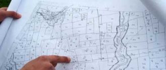
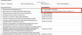
A boundary plan is a document that indicates the exact dimensions and boundaries of the property, lists access roads, as well as engineering buildings of public importance.
The boundary plan is the basis for compiling the cadastral register and is presented in the form of text and graphic drawings. It is being developed by an organization that the property owner has entrusted with geodetic surveying.
Data about the land survey site (size, boundaries, access routes, presence of water supply, gas pipe, etc.) are included in the land survey plan only after the land survey project has been approved. Work in the field of land surveying is carried out by a cadastral engineer, guided by the current norms of the legislation of the Russian Federation.
The main law regulating land surveying issues is currently Federal Law No. 78-FZ dated June 18, 2001 (as amended on July 13, 2015) “On Land Management” (as amended and supplemented, came into force on 01/01/2016).
After drawing up the design part of the boundary plan, the engineer submits it for review and further approval by the owner. If there are several of them, then the boundary draft, in order to avoid a boundary dispute, is sent for approval to everyone who has a property interest.
As soon as the owner has signed the boundary project, he has the right to apply for a certificate of ownership of the property with all the changes made. New information about land surveying is entered into the cadastral register, where it is stored until subsequent changes are made.
The land surveying procedure is carried out only if documents are available.
To avoid quarrels with neighbors, they are informed about the upcoming measurement of the land area no later than 7-8 days before the survey engineer appears on the site. Having received such a notification, the neighbor is deprived of the opportunity to start a land survey dispute based on his lack of information about the upcoming land survey.
Disagreements with neighbors
The boundaries of the land plot are determined by measurements carried out by a cadastral engineer as part of the land surveying procedure, and are then fixed in the graphic part of the land survey plan.
Before legally consolidating the boundaries, they must be agreed upon with all interested parties, in accordance with paragraph 1 of Art. 39 of the Federal Law “On Cadastral Activities No. 221. Interested parties may be neighbors who use their plots on the following basis:
- Ownership;
- Lease contract;
- Right of unlimited use;
- Lifetime inheritable ownership.
Signatures of neighbors in the act of approval of boundaries (on the back of the boundary plan of the land plot), according to clause 2 of Art. 40 Federal Law No. 221, give the cadastral engineer grounds to consider the boundaries fully agreed upon and document them.
Documentation
To install a boundary post and avoid a dispute over the boundary, you need:
- documents on ownership and right to use land;
- passport of the person who expressed a desire to carry out land surveying;
- application (submitted to a company licensed to conduct geodetic measurements);
- cadastral passport (if you don’t have it on hand, an extract from this document can be a replacement);
- boundary plan;
- a certificate confirming the presence or absence of public communications in the intervening territory (water supply, gas pipe, telephone cable may cause a dispute).
The specific list of papers depends on the region, the nature of the boundary dispute, and the economic purpose of the plot to be demarcated.
Note! In order not to return to the controversial issue of boundaries in the future, special boundary signs (poles) are installed between nearby areas. It is illegal to independently move boundary markers in any direction. If this happens, then the land surveying procedure will have to be repeated (moving the boundary post is a reason for a dispute in court on the issue of land surveying).
Land survey disputes - procedure
To survey the property, the owner is obliged:
- contact a geodetic organization and conclude an agreement with it on carrying out the necessary land surveying work;
- notify the owners of all plots with which his lands do not have a boundary (their presence is a prerequisite, since they are required to express their oral or written consent to the boundary).
Arriving cadastral engineer:
- measures the area of the site;
- records the obtained values in the survey report (the document is signed by the surveyor, the owner of the site, neighbors, representatives of local authorities).
After the specialists leave, the owner contacts the organization’s office to issue him a land survey plan. It takes up to 30 days to develop it. The customer is notified in advance of the deadline for drawing up the document at the stage of the boundary procedure.
Having collected this package of documents, the owner submits it to the State Register for registration.
If the boundaries of the property are changed after the documents have been submitted and all changes have been made, the survey will be carried out again. If the owner does not do this, he will not be able to exercise his right to use the site. It will be difficult to sell, lease legally, as well as perform any manipulations requiring official registration with such land, since its actual status will not be determined (there is no boundary).
Types of boundary disputes
A boundary dispute is always a dispute between neighbors, the subject of which is land, but the nature can vary significantly.
There are types of boundary disputes that arise:
- if neighbors have no information about the land survey that took place;
- when carrying out a land surveying procedure in violation of the law;
- between neighbors of nearby plots, if one of them refuses to restore the other’s violated rights;
- between neighbors, one of whom believes that the other has committed illegal actions against him (he has appropriated part of the land that does not belong to him);
- in the absence of any procedures to determine the exact boundaries of the site (land surveying has never been carried out).
Most often, neighbors try to resolve such boundary disputes on their own. By establishing an approximate boundary between plots and constructing a fence.
Unfortunately, the lack of legal justification for what happened in the future can lead to aggravation of the conflict situation between their heirs or new owners.
Example: Citizen Avdeeva I.I. received land ownership for farming. It was allocated to her in 1964. Her neighbor, citizen Ilyushina A.I., received similar land. Since both were civilly related, they decided not to establish a clear boundary between the property (the boundary) and did not even have a fence.
In 2009, Avdeeva I. I dies, her land becomes the property of her son, citizen Avdeev I. N. In turn, the neighboring property has already been owned by the granddaughter of the late Ilyushina A. I. for some time.
Having decided to sell the inheritance he received, Avdeev I. N. was faced with a problem such as the lack of a clear boundary between his plot and the plot of his neighbors (there was no demarcation). No documents have survived regarding the exact size of the land. Therefore, for a long time the neighbors used most of the plot that belonged to I. N. Avdeev for their own needs (garden). In order to sell the inheritance, the specified citizen entered into a boundary dispute with his neighbors regarding the return to him of the unauthorized portion of the inheritance. To resolve the boundary dispute, he went to court.
Is it possible to challenge land surveying?
In case of dishonest actions of the owner who draws the boundaries of the land plot by land surveying, it is permissible to file a claim in court. In this case, the culprit may be either the owner of the adjacent land plot or the cadastral engineer who committed the violation.
The algorithm of actions is as follows:
- File a formal complaint with the geodetic company that carried out the survey, or with the State Committee for Land Survey at the location of the site.
- At the place of application, submit an application with a request to correct a cadastral error or other violations that infringe on the civil and property rights of the plaintiff.
- If the injured person receives a negative official response, go to court on its basis.
- If no official document is forthcoming, then it is permissible to file a claim one month after the application.
- Apply to the district court with an application, collecting the required documents and paying the fee.
- In court, act against the guilty person, who may be a cadastral engineer.
- If the court makes a positive decision, based on this, demand the restoration of the borders. otherwise, it is permissible to file an appeal.
Based on a positive court decision, a new survey will be carried out . For a successful outcome of the case, you will need to collect reports from independent experts, who can be cadastral engineers from other geodetic companies, or submit a corresponding request to the State Property Committee department.
How to resolve a conflict
A lawsuit is one of the options for resolving a boundary dispute, but it is far from the best. Therefore, we will consider the possible actions of boundary disputants in more detail.
Peaceful solution
If neighbors have claims against each other after the land surveying procedure, they can still resolve them peacefully.
To do this you should:
- Carry out points on the terrain. The parties to the conflict invite specialists from the land management organization. Which mark certain points on the site that has become the subject of a boundary dispute. The location of which is included in the state register. The marked coordinates will be the boundaries of the site. In most cases, their definition becomes sufficient to reduce tension between neighbors to a minimum.
- Carry out the surveying procedure again. You can invite other specialists or require the presence of all neighbors. Those who took part in such a procedure during the initial paperwork and remember the approximate location of the boundary.
The surveying procedure must be carried out by an organization (commercial company) that has the appropriate license.
Without a license, installing a boundary line is considered illegal. Even if the correct calculations were used and the person in charge had the appropriate education.
Going to court
In paragraph 1, art. 64 of the Land Code of the Russian Federation states that the resolution of any land disputes, including boundary disputes, takes place in court. In paragraph 2 of the article in question, it is noted that before the case is transferred to an ordinary court, an arbitration court can deal with it. This opportunity arises only if an arbitration agreement is concluded between the parties to the conflict.
If the parties to the conflict are determined and each of them represents himself in this boundary dispute as an injured party, then the case is heard in an ordinary court.
After submitting the following documents to the office:
- land management business. All documents that indicate boundaries, dimensions, length, and coordinates of boundary markers. Cadastral plan, information about notification of persons whose interests are affected by the land surveying procedure;
- papers evidencing ownership of land. Which each side has. Each participant in a boundary dispute provides his own evidence base;
- conclusion of a land management expert. Provided if the completed land surveying procedure did not satisfy one of the owners, and disputes regarding land surveying arise;
- eyewitness accounts. If there were witnesses present during the transfer of land to the first owner and the installation of boundary signs, then their testimony should definitely be included in the case regarding the resolution of the boundary dispute.
Note! The defendant in a boundary dispute case has the right to file a counterclaim. Therefore, one cannot count on the fact that in the eyes of the court he will look like the culprit of the boundary dispute, and the plaintiff the injured party.
In addition, the defendant can also challenge the court's decision. What may cause an increase in the time for consideration of a boundary dispute (up to 2 or more months).
To obtain more complete information about the current situation, representatives of the judicial authorities have the right to conduct a personal inspection of the disputed territory requiring land surveying.
The final decision is made by the judge. Therefore, a lot depends on his literacy and desire to understand the problem that has arisen, having studied all the evidence provided as fully as possible.