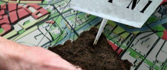
What is land redistribution?
Redistribution of privately owned land plots with undemarcated lands
What is land redistribution? This is a change in the boundaries of adjacent plots with the consent of two owners, with the establishment of new boundaries.
The procedure for redistribution of land plots is established by the Land Code of the Russian Federation (hereinafter referred to as the Russian Federation), in particular regulated by Article 11.7 of the Land Code of the Russian Federation. According to the Land Code of the Russian Federation, redistribution of land plots is a procedure for the formation of a new land plot by adding new land/another land plot to an existing plot. clause 1 art. 11.7 of the Land Code of the Russian Federation establishes that when redistributing lands and a land plot, the existence of the original land plot ceases and a new land plot is formed.
In practice, a situation often occurs: a plot of land runs under an individual residential building and it is necessary to cut off a front garden that is already in use by the owners, or cut off a plot of land that is located behind a vegetable garden. In this case, the question arises: what needs to be done to carry out redistribution? how to increase the land plot?
Let us explain, in this case, it is necessary to take into account certain rules when registering an “addition” to your land plot for individual housing construction:
— make sure that the land plot is demarcated;
— make sure that it is impossible to form an independent area from the cut-off territory;
— make sure that there is no land surveying project or redistribute in accordance with it;
— look in the Land Use and Development Rules on the municipality’s website, the “cut” territory and your site are located in the same territorial zone;
- check on the public cadastral map what the territory that the land user wants to cut off is.
As a result of the redistribution, an agreement is concluded with the body disposing of the land plots, which is subject to registration with the Rosreestr Office.
Based on the results of registration of the right, the applicant is issued an extract from the Unified State Register of Real Estate, which reflects the owner of the land plot.
Additionally, we inform you that the amount of payment for the redistribution of a land plot is calculated on the basis of the Decree of the Government of the Ulyanovsk Region dated April 10, 2015 No. 156-P “On approval of the procedure for determining the amount of payment for increasing the area of land plots that are privately owned as a result of the redistribution of such land plots and lands and (or) land plots that are state-owned in the Ulyanovsk region, as well as land plots for which state ownership is not demarcated.” The amount of the fee is determined as 15% of the cadastral value of the land plot, calculated in proportion to the area of the part of such land plot that is subject to transfer to private ownership as a result of its redistribution with land plots in private ownership.
Letter No. 11-00273/20 of Rosreestr dated July 17, 2020 provided clarification regarding the redistribution of the land plot.
Redistribution of lands and (or) land plots in state or municipal ownership, and land plots in private ownership, is carried out in cases and in the manner specified in Articles 39.28 and 39.29 of the Land Code of the Russian Federation. Paragraph 1 of Article 39.28 of the Land Code of the Russian Federation establishes the conditions that must be met when redistributing lands and (or) land plots in state or municipal ownership and land plots in private ownership. When carrying out the redistribution of lands and (or) land plots that are in state or municipal ownership, and land plots that are privately owned, in the cases established by subparagraphs 2 and 3 of paragraph 1 of Article 39.28 of the Land Code of the Russian Federation, the area of the land plot located in private property can be increased no more than up to the established maximum size of land plots. This condition limits the maximum size of a land plot to which the right of private ownership arises during the redistribution of lands and (or) land plots in state or municipal ownership and land plots in private ownership, and does not establish a ban on reducing the area of such a land plot . In the opinion of the Office, the stated rules do not prevent the formation of a land plot through redistribution, as a result of which the area of a privately owned land plot is reduced, subject to the requirements of Chapters I.1 and V.4 of the Land Code of the Russian Federation. It is also noted that in accordance with Article 11.2 of the Land Code of the Russian Federation, the redistribution of land plots is one of the ways to form land plots; accordingly, when creating land plots through redistribution (including when redistributing a land plot and lands), the requirements established by the Land Code of the Russian Federation must be observed requirements for the formed land plots, including regarding the maximum (maximum or minimum) sizes of land plots. Letter of Rosreestr dated July 17, 2020 No. 11-00273/20
How many acres can be added to a plot of land?
free of charge without bidding if this “additional” share is of a size not exceeding the minimum size of the plot determined for objects of a specific purpose. This rule is provided for in Art. 27 of the Law “On the State Real Estate Cadastre”.
For example, for the construction of dachas in the main part of the subjects of the state, a standard territory size of 6 acres is provided. Therefore, it will be possible to legalize no more than 6 additional acres.
But for the area for individual housing construction, no more than 3 acres are allocated, and it will be possible to increase it only by this amount, which is actually already used.
How to add land to an existing site
The redistribution of territories is carried out through the consistent implementation of measures, the implementation of which can guarantee a positive result:
- Drawing up and submitting an application. It should contain the following information:
- passport details of the applicant or details of a legal entity;
- cadastral numbering of land areas involved in the addition;
- information about the land surveying project (if it will be carried out on the basis of the project);
- contact details of the person applying.
- Preparation of the necessary documentation. Send it along with the application to the local municipality. Papers can be sent electronically or on paper.
- Consideration of the appeal and making a decision on it. In the absence of violations of the requirements established by land legislation, a decision may be made to approve the land layout plan. In this case, the applicant is sent approval for the execution of an agreement on the annexation of additional land based on the survey project. Municipal authorities may refuse to redistribute land for the reasons established in paragraph 9 of Art. 39.29 of the Land Code of the Russian Federation.
- After receiving approval, the person ensures that the necessary work is carried out to account for the land objects created as a result of the increase. To do this, you must contact the cadastral chamber with a corresponding application.
- Within one month, an agreement on the accession of additional space is prepared and sent to the applicant for signatures. This must be done no later than thirty days.
- The signed agreement must be submitted for registration to Rosreestr and an extract from the unified register must be obtained confirming the owner’s rights to the newly formed plot.
This is interesting: The adjacent territory of the residential complex
Redistribution of land plots in SNT
Publication date: 12/02/2020
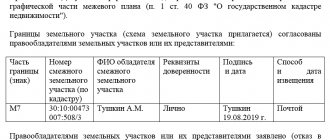
A boundary plan is a document drawn up on the basis of a cadastral extract or cadastral plan of a plot of land or territory. It contains information that is available in the state real estate cadastre. From the document you can learn about neighboring areas, the combination or division of territory, restrictions on their use, and it also indicates specified boundaries. A mandatory attribute of the boundary plan are diagrams and maps that provide comprehensive information about the delimitation of areas.
When is it necessary to redistribute the boundaries of land plots?
This procedure is carried out in cases where several adjacent territories need to be divided into other adjacent plots of land. In other words, redistribution involves the process of combining and dividing.
Conditions for redistribution of plot boundaries:
- The type of permitted use and category of land of the redistributed plots must match.
- Lots must have at least one common boundary.
- In the event of a division, each area must have separate access. It can be carried out through the establishment of an easement or through public areas.
- The redistributed plots must belong to the same municipality.
- The characteristic points of the redistributed areas are expected to be set with high standard accuracy. For Moscow it is 0.1 m.
- Availability of a protocol and consent to the redistribution of territory from owners, mortgagees, tenants and landlords.
Work required to create a boundary plan:
provides a range of services for developing a boundary plan. Every client who contacts us receives a finished result. By contacting us, you can receive the following services:
- creation of a boundary plan;
- submission of developed documentation to the cadastral chamber;
- obtaining a cadastral extract and certificates for new plots.
How does cooperation with us work?
To start cooperation with us, you can call, clarify your questions and make an application. Next, you need to send scanned documents to our email box. After this, we will develop an agreement that will indicate the price of services, the timing of their implementation and other conditions. At the next stage, the document is agreed upon with you, and changes are made to it if necessary.
At the beginning of cooperation, a power of attorney is issued to our specialist. He goes to the site and carries out the necessary work. Next, the documents are prepared by government agencies, and the result is provided to the customer.
The visit of a cadastral engineer is FREE. You do not have to visit our office; the cadastral engineer will come to you to conclude an agreement. Read more.
What documents are needed?
- cadastral plan;
- passport or other document proving the identity of the customer;
- title and title documents for a plot of land;
- power of attorney for our specialist to perform actions on behalf of the owner of the land plot.
provides turnkey services for preparing boundary plans.
By contacting us, you will soon receive all the necessary documentation with data entered into the cadastral chamber and other government bodies. Share this article